Thursday, August 31, 2006

Tracking Ernesto


It's been a busy day and night in the Weather on the Ones Forecast Center, so I will keep this brief. As I write this blog post, Ernesto is not far from making landfall along the southeastern coast of North Carolina. The heaviest rain amounts through the overnight and early morning can be expected just along and to the east of the storm's path. It appears the swath of heavy rain will set up to the east of the Triangle. In the News 14 Carolina viewing area, the highest rain amounts can be expected along I-95 and to the east. The Triangle still stands the chance to pick up a decent amount of rain, and we must all still very cautious as flooding cannot be ruled out early Friday morning. A Flash Flood Watch is in effect through Friday morning.

For the very latest on Ernesto, tune to News 14 Carolina on Time Warner Cable. Our team will staff the weather center through the overnight and early morning hours to provide you Ernesto updates every 10 minutes.

And, if you were wondering if there is anything else developing in the tropics.... take a look at the satellite image Thursday night off the African coast.
There are no organized systems there right now, but we'll have to watch those tropical waves as they move across the Atlantic. Stay tuned...

Wednesday, August 30, 2006

Still Looking at Threat for Heavy Rains from Ernesto

Could Wednesday afternoon's scattered showers and strong storms be a precursor of what's to come? That's a question we've been kicking around in the Weather on the Ones forecast center today. It certainly is a possibility. The storms from Wednesday formed ahead of a front moving into the state and were not the result of Ernesto.

Ernesto could bring problems our way late Thursday into Friday. Here's the forecast track from the 5pm Wednesday evening advisory --

Ahead of Ernesto look for heavy rains to spread into central North Carolina Thursday afternoon and evening. Those heavy rains will likely continue through Friday morning. Three to five inches of rain can be expected, but higher amounts are possible especially since Ernesto will be interacting with a stalled front. Isolated tornadoes could pose another threat just along the storm's track and to the right of the track.

For the very latest on Ernesto, tune to News 14 Carolina. We're your only local source for weather updates every 10 minutes.

Tuesday, August 29, 2006

Tuesday Ernesto Update

It was a scorcher of a day in central North Carolina today. The high reached 99 RDU which ties the warmest temperature we have recorded this year. We also hit 99 on August 3. We don't expect temperatures that hot for the rest of the week as we have big changes on the way including a front moving toward North Carolina and a tropical system named Ernesto.

Many computer models are still in agreement that Ernesto or what may remain of Ernesto will track over central or eastern North Carolina late Thursday or Friday...
and forecasters at the National Hurricane Center agree...

Ernesto is not a very strong tropical storm. As of the 8pm advisory Tuesday, the storm had sustained winds estimated at 45mph. With the storm about to move into south Florida, we would not expect any significant strengthening. The storm will likely weaken while it's over Florida during the day Wednesday. It may then move back over the Atlantic where it would have a small window to strengthen if it follows the NHC path back inland somewhere near Charleston, SC. Keep in mind the there is still room for error in the forecast track.

It does not appear that Ernesto will be a powerful storm when it comes to winds, but Ernesto poses another danger -- flooding rains. We continue to look at the possibility for a weather set up that would lead to very heavy rainfall over North Carolina Thursday into the day on Friday. A front that will move into the state Wednesday could stall out over the region. As I mentioned yesterday, these stalled out fronts tend to squeeze out very heavy rains from even weakened tropical systems. This may be the case as Ernesto moves in.

Wednesday afternoon and evening will bring some scattered showers and storms to the region, but these will be the result of the front and not Ernesto. Expect the rain to pick up during the day Thursday and continue through at least early Friday. The exact point where this front may stall out and the exact track of Ernesto will determine the locations that pick up the most rain. Three to six inches is possible with higher amounts certainly possible. Even though we are somewhat dry in central North Carolina, too much rain at once could easily lead to flooding. This is all not set in stone just yet. We'll continue to monitor Ernesto and fine tune our forecast as it approaches.

Stay tuned to News 14 Carolina, your only source for Ernesto updates every 10 minutes with Weather on the Ones.

Monday, August 28, 2006

Ernesto Could Bring Heavy Rains to North Carolina

Ernesto has been struggling to maintain its strength Monday as it interacts with eastern Cuba. As the storm pulls away from land, it may have the opportunity to restrengthen. There is still some uncertainty to the exact path the storm will take, but it does appear the east coast of Florida could be affected. Here's the forecast track from the 5pm National Hurricane Center advisory --
And here's a look at the different computer model forecasts for the storm's path as of Monday evening --


A lot of the models bring the storm, or what may remain of the storm toward North Carolina toward the end of the work week. We could use some rain across the state, but we may be setting up for too much rain in some areas. A cold front will approach North Carolina over the next couple of days and may stall out over our region. These stalled out fronts often act as the focus for heavy, and even flooding rains from tropical systems. You will probably recall the flooding in Raleigh earlier this summer when the remnants of Alberto moved through the state. A stalled out front was present then and focused the heaviest rains over the Triangle, especially over the city of Raleigh.

It is much to early to say if all of the weather variables will come together to produce flooding rains later this week, but we will have to monitor the weather situation very closely. Stay tuned to Weather on the Ones. We'll have the very latest on Ernesto every 10 minutes.

You can also find more information online from these links --

Sunday, August 27, 2006

Ernesto Update -- Could It Impact North Carolina?

When we talk about forecasts for tropical systems several days out, there is one statement you may hear often -- "The only definite thing about the forecast is that it will change." That statement has proven true today as the forecast for Ernesto has changed, and it will likely be fine tuned over the coming days. Here's a look at the track from National Hurricane Center (NHC) as of their Sunday 5pm advisory:
Ernesto had strengthened into a hurricane Sunday morning but then weakened back to a tropical storm Sunday afternoon. The storm brushed past the south and southwestern coast of Haiti.


The country of Haiti is fairly mountainous, and the frictional effects of a hurricane interacting with a mountainous land area often weakens a hurricane. As the storm pulls away from Haiti Sunday night, there is some potential for it to strengthen back to a hurricane, but it may not stay that way long. It will likely move across Cuba Monday and weaken some. Once it hits the warm ocean waters again, a strengthening phase could begin again. The bottom line -- look for changes in the intensity over the coming days.

The next question is where does the storm go once it moves past Cuba. The Florida Keys could be the next target. There are reports that tourists were asked to leave the Keys Sunday afternoon. That's not such a bad idea since there is only one way out of the Keys, and that part of Florida is often evacuated well ahead of a storm.

The Gulf coast of Florida could be Ernesto's next stop, but it is important to note that the storm could be anywhere in the shaded area on the above forecast track. That means even the east coast of Florida is not totally out of danger just yet.

The uncertainty in a tropical cyclone forecast grows after 3 days, but since it can take several days to make preparations for a hurricane, the National Hurricane Season has issued 5 day forecasts for the past few seasons. Take a look at the 5-day forecast from the 5pm NHC advisory --


You will note the forecast track takes Ernesto along the east coast including the Carolinas after it crosses Florida. If Ernesto does follow this path, it could have a big impact on our weather by late in the week or the weekend. However, the storm could be anywhere in the shaded area. If the storm takes a more easterly track out to sea, we would feel very little impact here in central North Carolina.

Some computer models are indicating a very interesting weather pattern for us by late in the week. It appears cooler air could settle into North Carolina and dam up against the mountains. This is a weather pattern that we see more often in the winter, but it does occur on occasion in the summer. If this does set up, it would keep us cloudy with some rain and daytime temperatures only in the 70s. This coupled with Ernesto could bring a lot of rain to the region.

Rainfall may not be such a bad thing for North Carolina though. As we mentioned late last week, moderate drought conditions have returned from the Triangle to the north. We just don't need the flooding rains that we experienced when the remnants of Tropical Storm Alberto moved through.

At this point, we cannot say for certain if Ernesto will impact North Carolina, but it is a possibility. It will be a busy week in the Weather on the Ones forecast center as we closely monitor the storm. We'll be sure to pass along the very latest information as we get it in our Weather on the Ones forecasts, so stay tuned...

If you'd like to track Ernesto and find out more information about the storm early this week, you may find these links helpful --

Saturday, August 26, 2006

Lightning Strikes Space Shuttle Launch Pad

A lightning strike at the space shuttle launch pad has delayed the launch of Atlantis. You can see video of the lightning strike here: http://anon.nasa-global.edgesuite.net/anon.nasa-global/ccvideos/sts_115/ksc_082606_scrub.asx

And, you can read more about the mission here --
http://www.nasa.gov/mission_pages/shuttle/main/index.html

Watching Ernesto

Undoubtedly, some residents along the U.S. Gulf Coast are nervous about Tropical Storm Ernesto this weekend. It is still too early to make a call where this storm will go. However, it does appear likely that this storm will make it into the Gulf of Mexico early next week. It also appears that this storm will become a hurricane either late Sunday or sometime early next week.

Ernesto has gained a little strength today. The storm is still encountering some wind shear, which appears to be keeping it from significant strengthening at this time, but that should change as the wind shear relaxes tomorrow. At that time, Ernesto could begin to strengthen rapidly. The official forecast from Saturday evening calls for Ernesto to become a hurricane Monday. Before then the storm will cross or, at least, move near Jamaica. Here are some links you can use to monitor the latest weather conditions in Jamaica --

After Jamaica, Ernesto's path could take it across western Cuba. Typically when a tropical system interacts with land, frictional effects will cause the storm to weaken. Since Jamaica and western Cuba are small and not mountainous, they should not have much of an impact on the strength of Ernesto. In fact, it looks like Ernesto will continue to strengthen as it moves into the Gulf of Mexico Tuesday. Check out the latest forecast track from the National Hurricane Center --

The forecast for Ernesto really becomes uncertain after it moves into the Gulf. Most computer models are in agreement up until this point, but don't agree so much on what happens after this. The latest data suggests the central Gulf coast to the eastern Gulf coast, specifically from Louisiana to Florida may need to be more concerned about this than the Texas coast.

Another concern for Ernesto is the storm's strength in the Gulf. Conditions in the Gulf should be favorable for it to continue to strengthen. The National Hurricane Center is now forecasting Ernesto to become a category 3 hurricane by Thursday. It is possible for the storm to be stronger than that, but again, it is way to early to say for sure.

News 14 Carolina viewers may wonder if this storm could ever affect the weather in North Carolina. Sometimes when a tropical system makes landfall on the Gulf coast, remnant moisture from the storm gets pushed toward the Carolinas. However, that does not always happen. If it did, that is still about a week or so away, so again, it is way too early to speculate any changes to our forecast in North Carolina.

The only sure thing about Ernesto is that the forecast for the storm will change over the coming days, so stay tuned. We'll keep you posted with tropical updates at :21 after the hour every hour on News 14 Carolina.

Friday, August 25, 2006

Drought is Back and Watching the Tropics This Weekend

The weather looks to be quiet in North Carolina this weekend, but there are still plenty of weather stories to talk about. I'll start close to home where drought conditions have returned to portions of central North Carolina -- Above is the state drought map updated this week. The darker shading represents "moderate drought" conditions. We've seen the moderate drought the last several weeks in southwestern North Carolina, but it has reappeared from the Triangle to the north. Our region has just not seen a good soaking rain recently. It appeared that we may have seen more widespread rain early this week, but that just did not pan out.

A lot of rains this time of year come in the form of scattered afternoon thunderstorms, so rain amounts have been hit or miss. The Raleigh-Durham Airport has measured over 2 inches of rain this month while the rain gauge at the National Weather Service Office on the NC State campus has measured less than half an inch.

We will not see any relief from the drought this weekend, but a front approaching the state next week will bring increased chances for rain especially on Tuesday and Wednesday.

You can read more about the drought in North Carolina by clicking to www.ncdrought.org.


Now to the big weather story of the weekend -- the tropics.
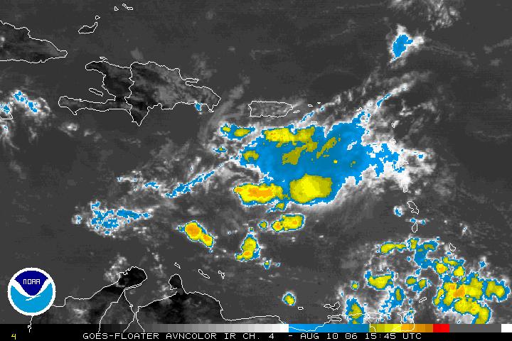
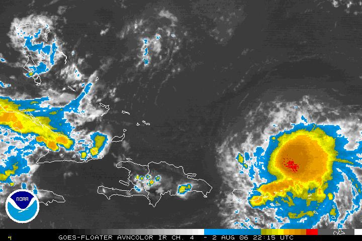
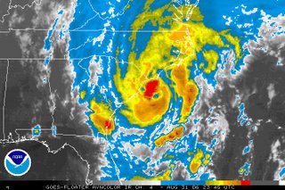
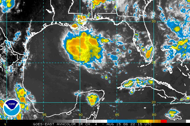
Above is a satellite image of Tropical Storm Ernesto from Friday evening. A hurricane hunter aircraft found that the system had strengthened into a tropical storm this afternoon. Ernesto will encounter wind shear in the upper levels of the atmosphere over the next 24 hours. Wind shear typically hampers any strengthening and sometimes causes weakening. The official forecast calls for Ernesto to maintain its strength or strengthen only slightly through the first half of the weekend.

By Sunday, that wind shear should diminish and Ernesto will move into an area that will be favorable for strengthening. As it moves toward the western Caribbean, ocean waters are very warm and the storm could become a hurricane by early next week.

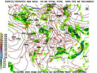
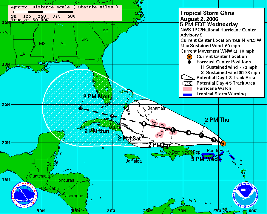
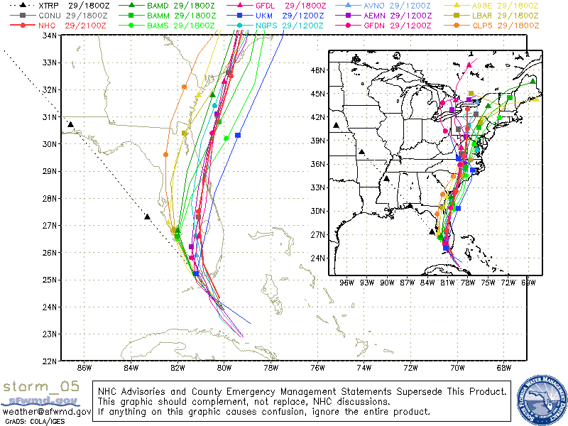
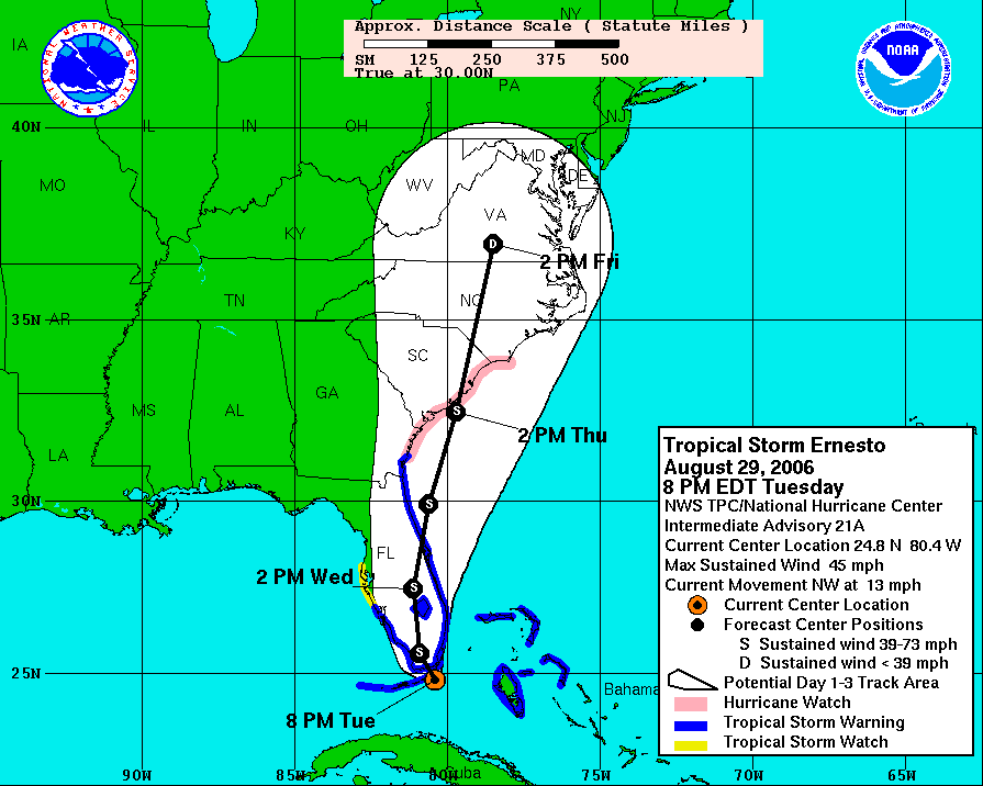
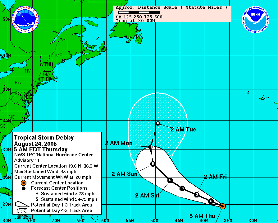
The next big concern is where will Ernesto go next week. Most computer models are in agreement that the storm will take a west-northwesterly track this weekend, but there is uncertainty on what will happen early next week. Here's a look at the forecast track from the National Hurricane Center as of Friday at 5pm:


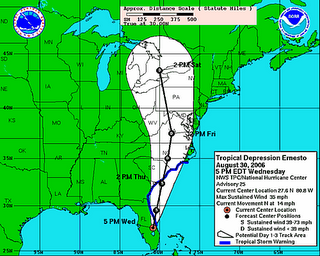
The NHC is forecasting Ernesto to move into the central Gulf by Wednesday. Keep in mind there is a lot of uncertainty with this forecast, especially since Wednesday is 5 days away. The storm can be anywhere in the shaded area from that track map. It is way too early to say exactly where Ernesto may go, but with the storm forecast to move into the Gulf, residents along the Gulf coast will have to watch this one very closely this weekend. You can bet there are a lot of nervous Gulf coast residents considering this coming Tuesday will be the one year mark since Hurricane Katrina devastated the central Gulf coast.

One other note about Ernesto. The forecast calls for the storm to be at category one hurricane Wednesday, but the National Hurricane Center has pointed out there is uncertainty with that intensity forecast. Waters in the central Gulf are very warm, and it is quite possible that Ernesto could be much stronger.

The bottom line on Ernesto... it's way too early to panic on this storm. A lot could happen over the next several days, so stay tuned. We'll keep you up to date with tropical updates at :21 after the hour on News 14 Carolina. You can also find more online at www.nhc.noaa.gov

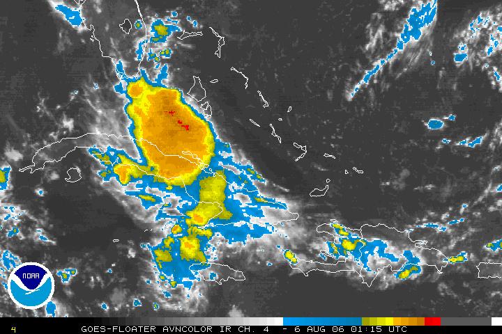
By the way, Tropical Storm Debby is still way out in the Atlantic and should remain out to sea not affecting land. With Ernesto potentially posing a threat to the Gulf coast next week, don't expect to hear much more about Debby.

Have a question about the hurricane season or the drought? Let us know in the comment section below.
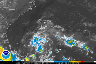
Thursday, August 24, 2006

Thursday Morning Tropical Update

Tropical Storm Debby has not changed much this Thursday morning. The storm is forecast to strengthen over the next few days and could become the first hurricane of the 2006 Atlantic season. Fortunately, it looks like Debby is a "fish storm," which is just another way to say this storm will not affect land. Here's a look at the forecast track for Debby from the National Hurricane Center Thursday morning:

A system that could be of more concern than Debby is a disturbance located east-southeast of the Windward Islands --

This system is becoming better organized and could become a tropical depression or even a tropical storm later in the day. If this system does become a tropical storm, it will be named Ernesto. The National Hurricane Center is sending a hurricane hunter airplane into the disturbance this afternoon to check it out.

Several computer models bring this disturbance into the Caribbean over the next couple of days. By early next week, if it develops, it could be close to the Gulf of Mexico. A lot can change quickly when it comes to the tropics, so we'll have to watch this one closely. We'll keep you posted. You can catch our latest tropical updates at :21 after the hour on News 14 Carolina. You can also find more information online by visiting the National Hurricane Center's website at www.nhc.noaa.gov

Wednesday, August 23, 2006

Looking Back to Katrina, Looking Ahead to the Rest of This Year's Hurricane Season

One year ago today a the 12th tropical depression of the 2005 Atlantic hurricane season formed near the Bahamas. That tropical depression would later become Hurricane Katrina and go down in history as one of the worst hurricanes to impact the United States. In the coming days, we will all hear a lot about Hurricane Katrina and the efforts to rebuild the Mississippi Gulf Coast and New Orleans one year after the storm. This week HBO is airing a Spike Lee documentary titled When the Levees Broke: A Requiem in Four Acts. This is the first of what will probably be many specials aired on different networks. You can catch showtimes and more information on this HBO documentary by clicking to http://www.hbo.com/docs/programs/whentheleveesbroke/index.html

With all the talk about Katrina, a lot of folks are comparing this year's season to last year. Fortunately, this season has not been as active as 2005's record setting season, but the rest of this season could still be more active that what is considered an average hurricane season. As September approaches, expect the tropics to heat up.

We are currently monitoring Tropical Storm Debby well out in the Atlantic. This storm appears to be gathering strength and could become a hurricane by the weekend. It does appear the storm will recurve out to sea before it ever comes close to the United States. Here's a look at the latest satellite image from midday Wednesday --
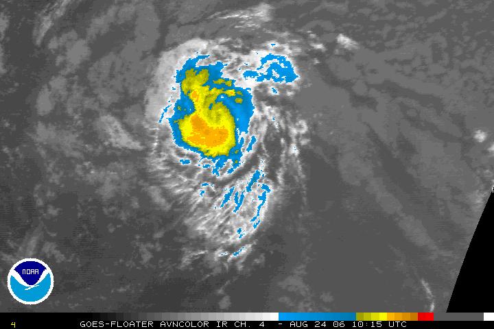
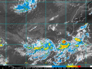
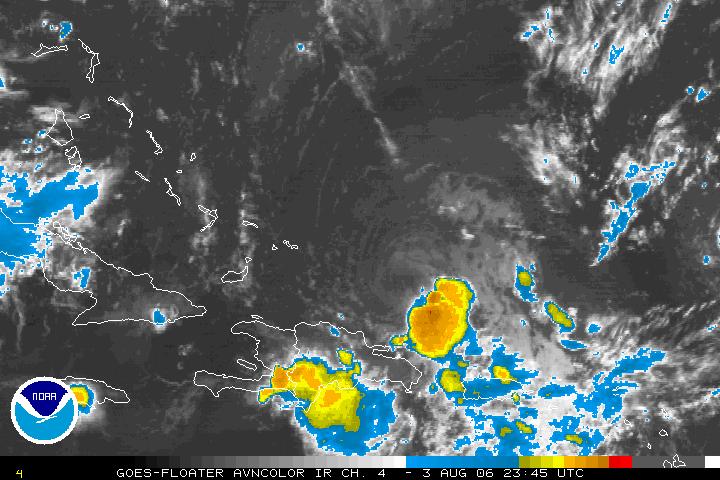
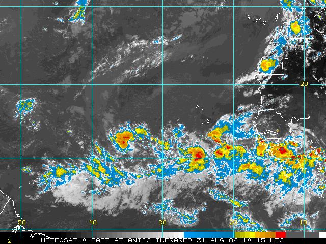
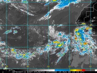
You see Debby on the right side of the image, but take a look and the cluster of thunderstorms to the southeast of the Windward Islands. That area of storms has the potential to become our next tropical depression over the coming days. We'll keep you posted with our tropical updates at :21 after the hour on News 14 Carolina. You can also find the latest on the tropics online by visiting the National Hurricane Center's website at www.nhc.noaa.gov


In other weather news, there is some evidence that El Nino could be returning by this winter. El Nino is the interaction between oceanic and atmospheric systems that impacts weather patterns across the globe. During an El Nino, we typically see fewer tropical systems. However, this upcoming El Nino will more than likely not develop in time to affect this year's hurricane season. You can read more by clicking to http://www.noaanews.noaa.gov/stories2006/s2679.htm

Saturday, August 19, 2006

Some Needed Rain on the Way

It has been a while since we talked about dry conditions in central North Carolina. You may remember the end of last year through the spring of this year when much of our region was under drought conditions. Late spring and early summer rainfall including the remnants of Tropical Storm Alberto helped to end our drought problems.

With no recent widespread rains, some dry conditions are returning to parts of North Carolina. Check out the latest state drought map from www.ncdrought.org:
The yellow shade represents areas that are considered to be "abnormally dry." The darker shading in southwestern North Carolina represents moderate drought conditions.

While we are not facing those drought conditions right now in central North Carolina, a good soaking rain would be welcome. The National Weather Service in Raleigh pointed this out in their afternoon discussion today. I'll share with you some of the stats they mentioned in today's forecast discussion. Falls Lake, which is the water supply for Raleigh, has been falling about 0.1 foot for the past week and was nearly one foot below full pool as of Saturday morning. Rain totals from RDU don't seem so bad. Since the first of August, the airport has recorded 1.76", but most of that came from localized thunderstorms. Compare that to 0.18", which is the rainfall so far this month at the National Weather Service Office on NC State's Centennial Campus.

Typically summer rainfall in central North Carolina is scattered because most of our summer rains come in the form of pop-up thunderstorms. You can see the example of this in this month's rainfall difference between RDU and the NC State campus.

We have a different weather pattern setting up for late Sunday and early next week that could bring needed widespread rainfall. A cold front will move into the state Sunday bringing scattered afternoon showers and storms by late day. Most computer models show that front hanging up, or becoming stationary, across the region for Monday and Tuesday. That would keep mostly cloudy skies around along with off and on rain showers and a few thunderstorms in the forecast for the first couple days of the week. Some of the models from earlier today suggested as much as one to two inches of rain would be possible from Sunday through Tuesday. Exactly what spots will see that rainfall? It will all depend on exactly where that front stalls out. We will keep you posted. Watch News 14 Carolina for our Weather on the Ones updates!

Thursday, August 17, 2006

Dewpoint Makes the Difference and a Tropical Update

Thursday was a warm yet comfortable day in the Triangle. Why was it such a pleasant day? The answer is the humidity. Drier air worked into portions of central North Carolina including the Triangle. Unfortunately, that drier air didn't quite make it to the Sandhills and points east of the Triangle where it wasn't quite as comfortable today.

To judge the "comfort factor," we rely on dewpoint. When dewpoints are in the upper 60s to low 70s, it becomes very uncomfortable outside. These are the levels we think of on a hot and humid summer day. Dewpoints were in this range from Fayetteville to Goldsboro this afternoon. However, in the Raleigh-Durham area, dewpoints were in the upper 50s to near 60 for a good part of the day. Those lower readings are somewhat unusual for this time of year, and they won't last much longer. The humidity will begin to increase over the next couple of days.

You can read more about dewpoint here --

On to another topic now -- the tropics. We continue to monitor a disturbance off the southeast coast.

The system drifted to the southwest today and is located off the Georgia coast as of this blog post. There is still a very small chance this could become a tropical depression, but time is running out for the disturbance. Upper level winds will not be favorable for development Friday. We'll have more on the tropics at :21 after the hour and you can also find the latest online at www.nhc.noaa.gov

Wednesday, August 16, 2006

Wednesday Update

The tropics are relatively quiet Wednesday evening. The last several days we've been keeping an eye on that disturbance off the southeast coastline. The system still does not appear very well organized as of this blog post --
The National Hurricane Center sent a hurricane hunter aircraft into the system Wednesday afternoon, but only found maximum winds around 25mph. This low still has a small window of time to become a tropical depression, but by late Thursday it will encounter upper level winds that are not favorable for tropical development. Those upper level winds will likely act to shear the disturbance apart. Even if it did become a weak tropical depression, it should not impact the North Carolina coastline.

Our forecast looks partly cloudy into the weekend. For more on the tropics, watch our tropical update at :21 after the hour. You can also find more information online at www.nhc.noaa.gov

Tuesday, August 15, 2006

Tuesday Tropical Update

As of this blog post Tuesday evening, there are no named storms in the Atlantic basin, but that could be changing over the coming days. There are several systems to watch this week. We'll start with the disturbance just over the southeast coast.
The above satellite image from Tuesday evening does not look too much different than the satellite image from last night. In other words, there hasn't been much organization of this system yet. However, there is still some room for this to potentially develop into a tropical depression over the coming days as it drifts a little closer to the Carolina coast. There is still some question on whether or not this will actually develop into a tropical cyclone. Of course, we'll keep you posted.

There is another system that appears better organized on satellite this evening. That disturbance is in the Gulf of Mexico --


Showers and storms associated with a trough of low pressure really blew up in the north central Gulf today. Sometimes a blow of thunderstorms like this will diminish with the loss of daytime heating. Other times, the storms hang on overnight, and if that happens, this system has the potential to become a tropical cyclone. As of now, this system is nearly stationary. However, anytime something develops in this part of the Gulf it almost has to move toward land since land surrounds it on pretty much all sides.

And much, much farther out in the Atlantic, here's a look at what's happening --

A tropical wave moved off the coast of Africa yesterday but diminished some today. Another cluster of storms appears to be moving toward the coast this evening. This area near the Cape Verde Islands off the African coast typically becomes active toward late August and early September, so this is just another region that needs to be watched.

For the very latest on the tropics, tune in for our tropical updates at :21 after the hour every hour. You can also find more information online at www.nhc.noaa.gov

Monday, August 14, 2006

Watching the Tropics this Week

There are a couple of things to watch early this week in the tropics. The first system is not too far away from the Carolina coast. Here's the satellite picture off the southeast coast from Monday night --

An area of low pressure is forming east of the Florida coast near the Bahamas. This is located along an old cold front that moved through North Carolina this past weekend. The disturbance is encountering some dry air as I write this blog post Monday night, but conditions may become favorable for tropical development over the next day or two. The National Hurricane Center has scheduled an aircraft to check out this area Tuesday if necessary. The disturbance is nearly stationary right now but may slowly drift to the north over the next couple of days. There is uncertainty to whether this system will develop or not and to what direction it may move. We'll keep you posted...

The other system we are watching is much farther away...
That is the satellite picture from Monday night off the African coast. An area of thunderstorms moved off the coast today moving toward the Cape Verde Islands. There is some potential this could also slowly develop over the next couple of days.

For the very latest on the tropics, you can always tune in to our tropical update at :21 after the hour on News 14 Carolina or visit the National Hurricane Center's website at www.nhc.noaa.gov

Friday, August 11, 2006

Dreary Start to the Weekend

Look outside the office window this Friday and it almost looks more like a winter day than a summer one! Here's the view from the DOT camera in downtown Durham from around midday: While it certainly doesn't feel like a summer day, it is cooler than what is normal for this time of year. As I write this blog post, temperatures are holding steady in the mid to upper 70s and will more than likely struggle to warm to the low 80s through the afternoon. Neighborhoods that see a few peeks of sunshine may see the mid 80s.

Along with the clouds, occasional showers will be possible through the day. A disturbance will approach the Sandhills late this afternoon and evening and that could lead to more intense showers and storms in that part of the state. Some heavy downpours will be possible in the strongest storms.

The forecast isn't much brighter for Saturday. Clouds and a few showers will hang out for at least the first half of the day. That will keep temperatures in the 70s for much of the day. We should see some clearing late in the day from the north to the south. The exact timing of that clearing will determine our afternoon highs. It appears temperatures may only warm to the upper 70s. However, if the sun comes out a little sooner, afternoon readings may reach the low 80s.

Sunday will be the best weekend day weatherwise. We are looking for mostly sunny conditions and pleasant temperatures in the mid 80s.

Have a great weekend and don't forget your latest weekend weather update is always less than 10 minutes away with Weather on the Ones on News 14 Carolina!

Thursday, August 10, 2006

More on the Tropics and Looking Ahead to the Weekend Forecast

I was surfing around the internet today and found an interesting article from NOAA on the hurricane season. It touches on a lot of points I made in my hurricane season post yesterday. The article also points out hurricane preparedness information and a few hurricane misconceptions. You can check it out at this link -- http://www.magazine.noaa.gov/stories/mag205.htm


In the tropics this Thursday, we are still watching the tropical wave that was just east of the Windward Islands yesterday. Today that wave is in the eastern Caribbean but does not look as organized as it did around this time yesterday. The National Hurricane Center did send a hurricane hunter airplane into the system yesterday, but they did not find a closed center of circulation. Another plane was scheduled for today, but they have cancelled that mission as the system is not very well organized. The NHC said in its midday update that conditions are not favorable for development of this wave over the next couple of days. Elsewhere, the tropics are quiet for now.

Now our attention turns to the forecast for the rest of the week and the weekend. Scattered thunderstorms should develop this afternoon and tomorrow afternoon. With daytime heating today, one or two of those storms may get a little strong with heavy downpours and gusty winds. However, not everyone will see the rain today.

The forecast for Saturday is looking a little more uncertain. A couple of the computer models that we use to forecast weather are suggesting Saturday could shape up to be a cloudy, cooler, and wet day. Here's a look at the output from the NAM model for around midday on Saturday.


This model almost suggests something that we call a "wedge" setting up in North Carolina. You may recall meteorologists talking about this pattern more in the winter months. High pressure in the northeast brings winds from the northeast into the area. That brings in cooler air into the state that wedges up against the mountains. That would also keep cloudy skies and at least light rain showers in the area through the day. If this pattern does pan out, temperatures on Saturday may not get much warmer than the 70s! One of the latest models out around midday today is forecasting a high of 67 for Raleigh on Saturday. Not bad for August in North Carolina when our highs are typically in the upper 80s. If the clouds don't hang on and we see some sun, temperatures would warm into the 80s.

As I mentioned, there is still some uncertainty in the forecast for Saturday, so you'll probably notice some changes in the forecast over the next day. We'll keep you posted with the latest forecast on news14.com and every 10 minutes with Weather on the Ones on News 14 Carolina.

Wednesday, August 09, 2006

Update on the Hurricane Season

At this point in the hurricane season last year, nine named storms had already formed. This year we have only seen three named storms. It seems this year has been fairly quiet, but that is easy to say when you compare this year to last year's record breaking season. According to hurricane climatology from 1944 to 1996, we typically don't see a third named storm until August 21. So, we could say we are running a little above average so far. As we have pointed out a few times on this blog, the season will more than likely pick up over the coming weeks. The Atlantic hurricane season usually has its peak in September.

Over the last several days you may have read or heard news that hurricane forecasters have baked off their original forecast for the number of storms this year. While most forecasters have reduced the number of hurricanes expected this year, we should really take this information with a grain of salt. The forecast for the rest of the season still calls for an above average number of storms. Here's the latest forecast from NOAA --


Remember this is just a forecast for the number of storms that are expected to form in the Atlantic and does not say anything about the number of storms that may make landfall. Many meteorologists will bring up the year 1992 to make a point about forecasting the number of hurricanes. 1992 was a below average season in the number of hurricanes that formed. There were only six named storms that year, four of which became hurricanes. Sounds like a pretty quiet season, unless you remember that was the year that Hurricane Andrew made landfall in south Florida causing billions of dollars in damage.

No matter how many named storms or hurricanes are in the forecast, it only takes one to cause major damage along the United States coastline. We all have to remain alert through the end of the season.

You can read more about hurricane season and the forecasts for this year through the following links:
Count on News 14 Carolina to bring you the latest on the tropics every hour through the rest of the hurricane season. You can catch our tropical updates at :21 after the hour.

We also periodically discuss what is happening in the tropics here on our Weather on the Ones blog. As I write this blog Wednesday afternoon, a disturbance just east of the Windward Islands has caught our attention.

This is a tropical wave that formed when it moved off the coast of Africa last week and moved to the west. Last night it appeared this wave had almost diminished all together. However, thunderstorms have flared up with the wave this morning. The National Hurricane Center has scheduled an Air Force Reserve Reconnaissance Aircraft to fly into the system this afternoon. We'll keep you posted on the latest. Again, for the latest tune to our tropical updates at :21 after the hour or check out the National Hurricane Center's website at www.nhc.noaa.gov


Saturday, August 05, 2006

Weekend Update


Tropical Depression Chris dissipated over Cuba Saturday morning. You can see from the above satellite image taken Saturday evening that there has been a flare up in thunderstorms from what remains of Chris over Cuba and just north of Cuba. We'll have to watch the remnants of Chris and it drifts toward the Gulf of Mexico.

Elsewhere in the tropics, we'll also be watching a tropical wave moving off the coast of Africa...

As that wave moves to the west, there may be some room for slow tropical development into early next week. For the latest on the tropics online, visit the National Hurricane Center's website at www.nhc.noaa.gov or tune in to our tropical updates at:21 after the hour on News 14 Carolina.

In North Carolina weather news, we did have some relief from the heat this Saturday. It wasn't a lot as we still hit a high of 89 at RDU, but that sure does beat the upper 90s and heat index values near 110 that we experienced the last several days! Our forecast does include a slight warm up to the low to mid 90s early next week. Normal early August highs are in the upper 80s to near 90.

Thursday, August 03, 2006

Record Heat and a Tropical Update

The big weather story in central North Carolina will continue to be the heat for at least for one more day. Highs soared to 99 Thursday afternoon at the Raleigh-Durham Airport. That broke the old record high of 96 set in 1987. It felt hotter than that 99 this afternoon though. At one point, I saw the heat index at RDU climb as high as 110!

We may set another record or at least tie it Friday afternoon. The record high for August 4 at RDU stands at 96 set in 1980. Highs will likely reach the mid to upper 90s with heat index values as high as 105. With the heat of the day, scattered showers and storms could develop by the late afternoon and evening hours. These showers and storms may be a little more numerous than the few isolated storms we saw Thursday afternoon and evening. We'll keep a close eye on Stormtracker Doppler radar Friday afternoon as storms may become strong with heavy downpours, frequent lightning, and gusty winds.

A slight cool down is on the way for the weekend. Of course, this "cool down" is all relative. It is early August after all! Highs in the upper 80s are expected Saturday and Sunday. That is near normal levels for this time of year, but it sure does beat the upper 90s! If you are thinking about outdoor plans this weekend, keep an eye to the sky as thunderstorms will be a possibility both Saturday and Sunday afternoons.

Now from the heat to the tropics... Take a look at the satellite image of Tropical Storm Chris from Thursday evening --

and compare it to this satellite image from Wednesday evening --

Chris weakened Thursday morning as it entrained drier air into the storm. It is barely hanging on as a tropical storm as I write this blog. However, the latest satellite imagery shows storms may be again building around the center of circulation. As of the 8pm advisory, the National Hurricane Center is still forecasting Chris to weaken to a tropical depression within the next 12 to 24 hours. As with any tropical system, there is some uncertainty to exactly what Chris will do. For the very latest information, you can visit the National Hurricane Center's webpage at http://www.nhc.noaa.gov or tune in for our tropical update at :21 after the hour on News 14 Carolina.

Wednesday, August 02, 2006

North Carolina Heat and the Tropics

Two big weather stories this Wednesday -- the heat and tracking Tropical Storm Chris.

Let's start with the heat... Today's afternoon temperatures topped out at 97 at the Raleigh-Durham Airport and 99 at the Fayetteville Regional Airport. I saw our thermometer at News 14 Carolina reach 102 this afternoon before a small isolated thunderstorm briefly cooled things down in north Raleigh. Our high here off of Atlantic Avenue was higher than the high at the airport likely due to the fact that we are in the city surrounded by buildings, asphalt, and concrete.

A ridge of high pressure will still be our main weather maker for Thursday. That will keep us hot with highs back in the upper 90s to near 100. With the humidity, the heat index could reach 110. Because of that, the National Weather Service has placed much of central and eastern North Carolina under an Excessive Heat Warning for the afternoon hours. To find out more about excessive heat warnings and heat safety you can visit this link -- http://www.erh.noaa.gov/rah/heat/

The intense summer heat typically leads to stagnant air over the Triangle. That traps pollutants from cars and industry close to the surface and that can make for bad air quality. Thursday will be another code orange ozone action day in the Triangle. News 14 Carolina reporter Grethchen Bartelt filed an informative report today about ozone levels in North Carolina, how they are measured, and how they can affect those with respiratory problems. You can check out that report at this link -- http://rdu.news14.com/content/top_stories/default.asp?ArID=88610

Now on to the other big weather story of the day -- Tropical Storm Chris...

That is the latest satellite image of Chris as of Wednesday evening. The storm remains fairly organized, although it did weaken slightly late in the afternoon. As of the 5pm advisory from the National Hurricane Center, Chris has maximum sustained winds around 60mph. The NHC is forecasting the storm to become a hurricane by Friday and pass very close to south Florida and northern Cuba late in the weekend. The storm may then move into the Gulf of Mexico early next week. Here's a look at the forecast track from the NHC as of Wednesday evening --


It is important to note that the storm can be anywhere in that shaded area within the next 5 days. The margin of error with tropical storm and hurricane track forecasting increases as the forecast goes out in time. In other words, a lot could change between now and the weekend, but residents of south Florida and the US Gulf Coast should start watching this one.

It is too early to say exactly where Chris may go, but it does have room to intensify over the coming days. We'll keep you posted. Catch our tropical update at :21 after the hour every hour on News 14 Carolina. You can also find the latest online from the National Hurricane Center at http://www.nhc.noaa.gov