Wednesday, February 28, 2007

Storms Possible Thursday Night

March may start out like a lion for much of the southeastern United States including North Carolina. We're closely watching a storm system that is forecast to produce severe weather across the southeast Thursday. The Storm Prediction Center (www.spc.noaa.gov) has placed much of the southeast under a moderate risk for severe weather --


Much of North Carolina has been placed under a "slight risk" for severe weather. Our greatest threat for stormy weather may come late Thursday evening into early Friday morning. Thursday night will be one of those night that you'll want a NOAA Weather Radio on standby mode in your bedroom to alert you to any severe weather warnings.

We'll continue to closely follow the latest weather data coming into the forecast center. Stay tuned to News 14 Carolina for Weather on the Ones updates.

La Nina Coming Back?

Scientists with NOAA's Climate Prediction Center announced this week that it appears El Nino is fading and we may be transitioning into a La Nina phase. El Nino and La Nina describe interactions between the ocean and atmosphere that can affect weather patterns across the globe. Warmer ocean waters in the tropical Pacific typically signifies an El Nino pattern, and the cooling of those waters represents La Nina.

Hurricane season in the Atlantic basin is just one of the weather patterns that can be affected by El Nino and La Nina. During an El Nino year, there are typically fewer hurricanes in the Atlantic and Gulf of Mexico. However, during a La Nina year we usually have a more active hurricane season.

You can read more by clicking to NOAA's recent press release on La Nina --
http://www.noaanews.noaa.gov/stories2007/s2805.htm

Sunday, February 25, 2007

The Week Ahead

Luckily, North Carolina avoided severe weather Sunday. The Triangle and Triad mostly just saw spotty showers through the day. A few thunderstorms did develop Sunday evening south and east of the Triangle.

Sunday's rain is long gone now, and it's time to look ahead to the new work week. We'll stay dry through the middle of the week. Afternoon temperatures should range from near normal to just above normal for this time of year.

Our next chance for rain will come toward the end of the week. Some computer models suggest we could see a lot of rain late Thursday and Friday. We'll continue to fine tune our forecast through the week. Stay tuned for Weather on the Ones updates only on News 14 Carolina!

Saturday, February 24, 2007

Showers and Storms for Sunday

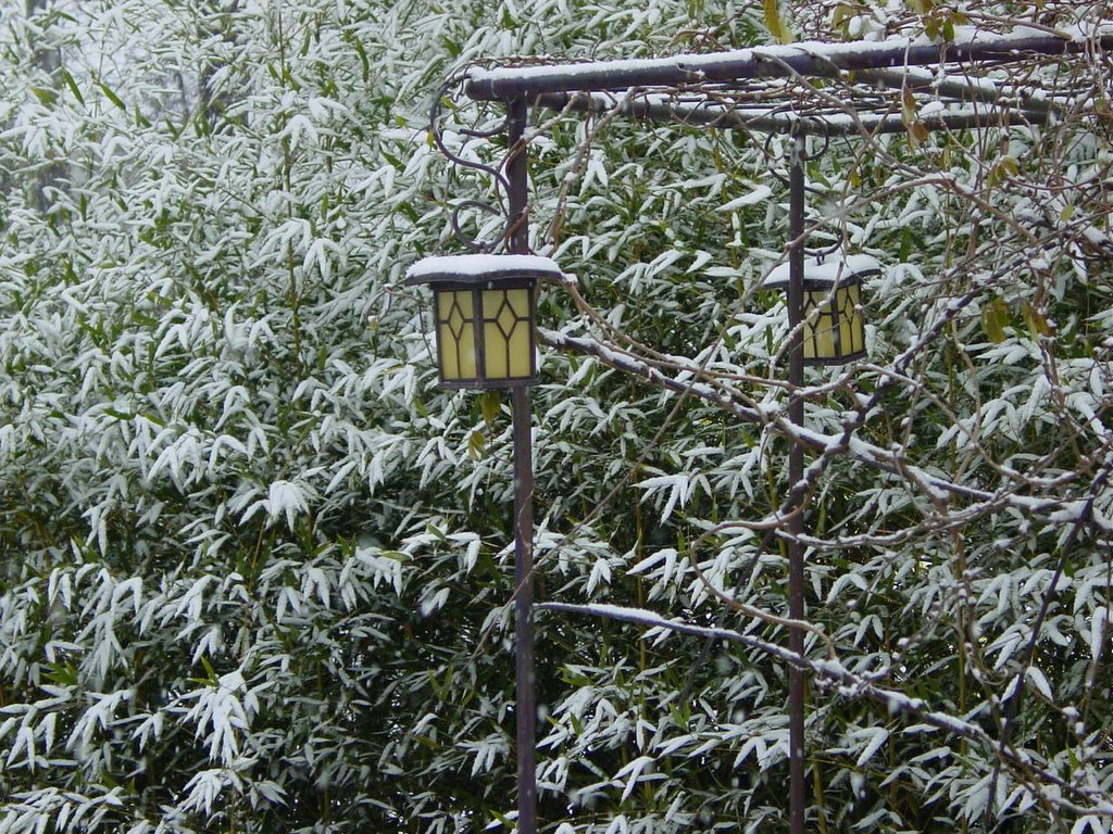
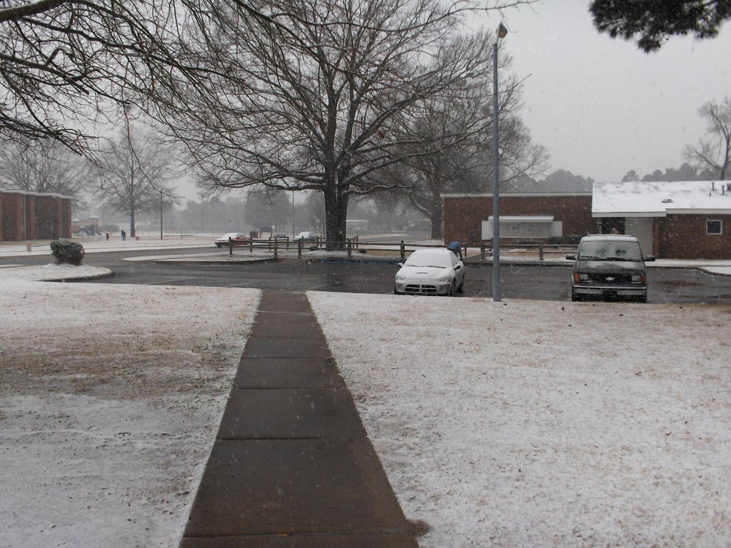
A storm system that's packing quite a punch for parts of the country will bring showers and thunderstorms to North Carolina for the last half of the weekend.


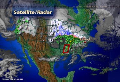
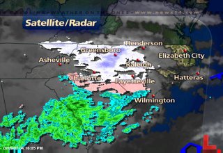
The above satellite and radar image from Saturday evening shows this big storm. On the north side of the storm, snow has impacted travel around Chicago and other parts of Illinois, Iowa, Wisconsin, and Minnesota. On the storm's southside, severe weather has been a big problem.


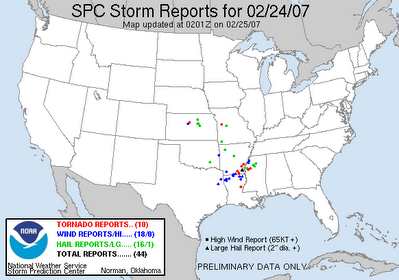
The above image from the Storm Prediction Center (www.spc.noaa.gov) shows Saturday's severe weather reports as of around 9pm. The red dots indicate tornadoes, the blue dots are reports of wind damage, and the green dots represent reports of large hail.

This storm system will continue to move to the east impacting our weather for Sunday. We can look for rain showers in our area by midday with the rain picking up in the afternoon. At that point, a few thunderstorms will be possible. A few of those could become strong.

The Storm Prediction Center has outlined eastern North Carolina for the slight risk of severe thunderstorms. If storms develop in this area, they will have the potential to produce gusty winds, hail, and isolated tornadoes. Any severe weather Sunday is not expected to be as widespread as Saturday's severe weather across the lower Mississippi River Valley. However, we'll have to keep a close eye on Stormtracker Doppler radar through the afternoon. Stay with News 14 Carolina for Weather on the Ones updates every 10 minutes.

Friday, February 23, 2007

Thursday's Fires and Tracking This Week's Weather

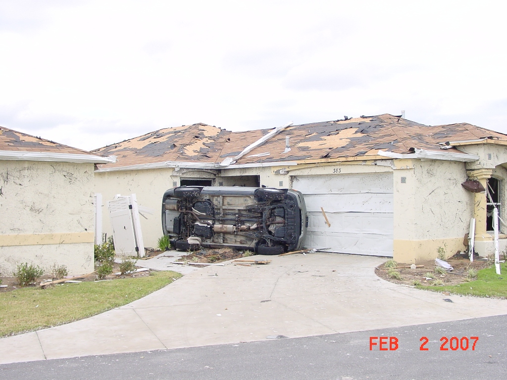
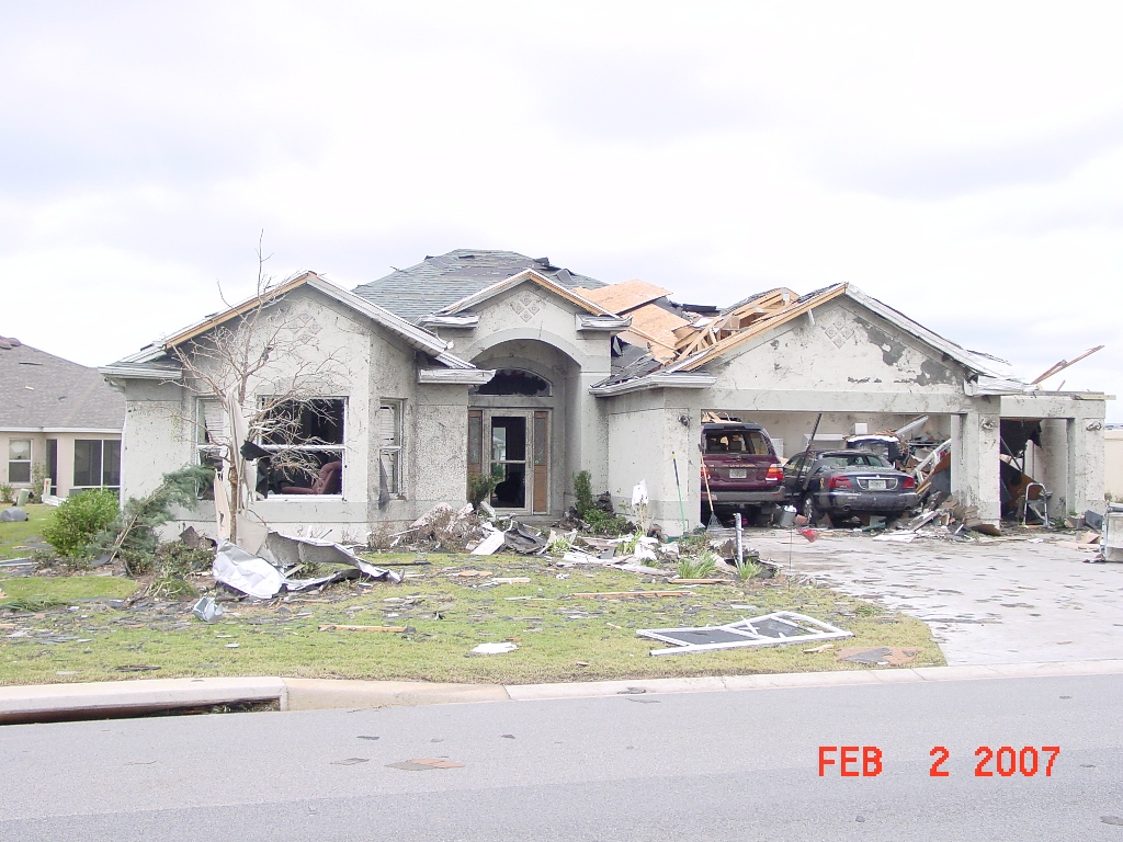
Thursday was a tragic day for fires in central North Carolina. Windy weather and dry conditions allowed fires to spread rapidly, and that certainly was the case as we watched over two dozen townhome units go up in flames in north Raleigh. You can read the latest on this and other fires around the area Thursday on our website at www.news14.com.

Thursday's fires were visible on radar and satellite imagery --

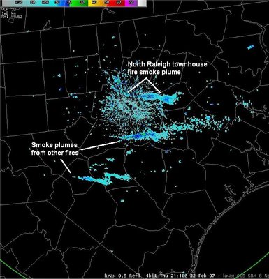
The National Weather Service's Doppler radar picked up on smoke plumes from the north Raleigh townhomes fire and the brush fire in Hoke County.

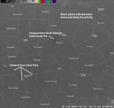
The above satellite image from Thursday afternoon also shows the fires. The darker pixels shows hotspots created by the fires.

Today isn't a much better day for fire weather. While a fire weather watch was cancelled this morning, all outdoor burning should be avoided today. Northwest winds at 10 to 20 mph along with low humidities could still allow any fire to spread rapidly.

Our breezy weather should diminish this Friday evening, and our attention in the Weather on the Ones Forecast Center will turn to a potent storm system developing over the nation's midsection.

The Storm Prediction Center (www.spc.noaa.gov) is watching an area from Kansas to Oklahoma to north Texas for the potential of a severe weather outbreak including tornadoes this afternoon.


That same storm system could produce severe weather across parts of the southeast on Saturday. The SPC is watching an area from Arkansas to Louisiana to Mississippi for the greatest threat of severe weather on Saturday.

The storm will eventually spread rain toward North Carolina on Sunday. While we don't look for a severe weather outbreak in our area, thunderstorms will be possible in southeastern North Carolina. We'll keep an eye out for the possibility for a strong storm or two. Stay tuned to News 14 Carolina for Weather on the Ones updates through the weekend.

Thursday, February 22, 2007

Why So Many Fires?


Thursday turned into a frightening day for fires in North Carolina. At least two fires engulfed homes and apartments in Wake County. One of which was a major blaze on the north side of Raleigh displacing residents and charing everything in its path. From all reports, the scene was chaos and left firefighters in a defensive stance against the flames.

There was an ideal set up for something of this horrific nature to take shape. We certainly cannot anticipate a large fire like this to happen, but on days like today it can occur more easily than others. It was dry, warm, and there wasn't much moisture in the atmosphere. However, the last ingredient made for a monster of a firestorm- wind.

Winds through North Carolina were whipping from 20-30 miles per hour with gusts as high as 35-40 mph! When you take such strong winds, throw in relative humidities as low as 10-15% the perfect breeding ground for fires is set. Forecasters along with the National Weather Service can anticipate these conditions and the NWS will issue what is known as a Red Flag Warning.

At 2:35 Thursday afternoon the Weather Service issued a Red Flag Warning. Some of the text included with the warning is as follows...
A RED FLAG WARNING MEANS THAT CRITICAL
FIRE WEATHER CONDITIONS ARE OCCURRING
AND ARE EXPECTED TO CONTINUE. A COMBINATION
OF STRONG WINDS...LOW RELATIVE HUMIDITY...
AND WARM TEMPERATURES WILL CREATE EXPLOSIVE
FIRE GROWTH POTENTIAL.
It's important to pay attention to what is happening on dry and windy days. You'll usually hear us say do not conduct any open burning and be careful using open flames. As always, never throw cigarettes out of a moving car. Fires can begin at a moments notice on a day like today. Stay tuned to News 14 Carolina and The Weather On The Ones forecast for more details on our current weather and when conditions are expected to improve.

Warm and Breezy Thursday

Temperatures have soared to near 70 early this afternoon, and the record high for today of 71 at RDU could be in jeopardy. That record high was set in 1955. Breezy conditions may make it tough to enjoy the nice weather at times today. Winds will pick up through the day with sustained winds at 15 to 25mph possible. It is not out of the question to have wind gusts up to 40mph in some spots.

Today's windy weather is created by a couple of factors. An area of low pressure is strengthening off the coast of New Jersey. The tightening of the pressure gradient, or the big change in pressure over a small area, created by that strengthening low makes for a windy day. Combine that with a front moving through North Carolina this afternoon and that and that explains why some spots may see those gusts up to 40mph.

Don't get too used to temperatures in the 70s. The front moving through today will bring cooler air to the state this evening. Lows will drop to the 30s tonight with highs in the 50s for Friday.

Temperatures will warm some by the second half of the weekend ahead of our next storm system. That will produce rain for central and eastern North Carolina by Sunday afternoon and evening. In fact, the Storm Prediction Center (www.spc.noaa.gov) is watching the region for the possibility for thunderstorms on Sunday --


We'll continue to fine tune the forecast as needed into the weekend. Stay with News 14 Carolina for Weather on the Ones updates every 10 minutes.

Tuesday, February 20, 2007

Ice Ice Baby...

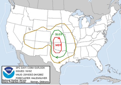
It's been so cold in the Midwest that parts of Lake Michigan started to freeze in February! This image was taken from visible satellite and shows ice gathering on the western edges of the lake. Some cities closest to the forming ice are Chicago and Milwaukee. Conditions were nearly ideal to create lake ice as temperatures dipped below freezing from January 24 to February 19. During that stretch the mercury was well below zero for many hours at a time. Follow this link to see what forecasters in Chicago are saying about a return to milder weather this week.

A little closer to North Carolina we're on the verge of putting together three consecutive 60-degree days for the first time since mid-January. It seems highly likely that hitting 60 or higher from February 20-22 would be the warmest three days since January 14,15,16.

We're also on the cusp of seeing some dramatic warm and cold swings. As is the case once we reach March and April warmer air begins slugging it out with cold air over the Eastern U.S. This leads to periods of warm and cold days with unsettled weather dividing them apart- usually in the form of rain and thunderstorms. Here's a look at the GFS Model at 850 mb for Sunday evening February 25. It shows an occluding low over the Midwest lifting warm air ahead of it and pulling down relatively colder air behind it. It's these swings in temperatures that signify a changing of the guard- as the atmosphere prepairs for the onset of Spring. Which is a little more than one month away!

Sunday, February 11, 2007

Looking for Snow?

New York snow photo from News 10 Now

Snow lovers, I know you're hoping for more snow before the end of the winter season here in North Carolina. While we don't have any snow in our forecast the next several days, I'm sure the folks in upstate New York would love for us to take some of their snow. Lake effect snows dumped over 100 inches of snow in some locations. News 14 Carolina's sister channel News 10 Now in Syracuse, New York covers some of these areas. You can read stories of the snow and see pictures on their website at www.news10now.com

Saturday, February 10, 2007

Was it snowing Friday?

Take a look at the satellite and radar image across the Carolinas from Friday afternoon --

At first glance of Friday's radar image, the answer would be -- yes, it was snowing. But, did you see any snow Friday afternoon? I didn't and mostly likely the only snow in North Carolina was in the form of isolated flurries in the mountains.

No, nothing was wrong with radars across the state Friday. There was precipitation falling from the clouds, but it was just too dry for any of that snow to reach the ground. Dewpoints at 4pm (same hour the radar image was captured from) were -4 in Raleigh-Durham, -6 in Greensboro, -7 in Fayetteville, and -13 in Winston-Salem. That's some dry air! All the snow from the clouds evaporated before we ever saw any of it.

So will we see any snow in the next few days? We will be watching a storm system that will spread precipitation across the state on Tuesday. As of now, it appears that most of that precipitation would be in the form of rain. As low pressure develops off our coast late Tuesday, it will draw some cooler air into our region. If there is still some precipitation around at that time, the precipitation may end as light sleet or a light wintry mix. It would probably be too light to cause any problems. However, if the track of this storm system is somewhat different than the current forecast, the precipitation that we see could be different.

We'll continue to monitor the latest weather data and keep you informed with the latest forecast. Just stay tuned for Weather on the Ones only on News 14 Carolina!

Wednesday, February 07, 2007

Looking Back at Last Week's Snow

Viewer photo from snow in Fayetteville on February 1, 2007

The National Weather Service Forecast Office in Raleigh has released an excellent discussion on the hows and whys of last week's winter weather. Snow totals of up to 2 inches were reported in the southern Piedmont and Sandhills of the state. For those of you who are really into weather, the discussion is a great read. Check it out at the following link --

http://www4.ncsu.edu/~nwsfo/storage/cases/20070201/

For snow lovers looking for more snow this winter, the news isn't too good for the next few days. While cool weather is in the forecast through the weekend, the forecast will remain dry. The next weather system that could produce precipitation for our area may come Tuesday of next week. It's really too early to make a definite call on this system right now. Some of the latest model data suggests it may be just warm enough for this to be all rain. We'll have to watch the temperatures closely. It is winter in North Carolina and a lot could change between now and then. We'll keep you posted. Stay tuned to News 14 Carolina for Weather on the Ones updates!

Tuesday, February 06, 2007

The Word Cold Isn't Enough...

It's too bad there aren't any acceptable words to describe how frigid our morning temperatures were through North Carolina. I'm sure there are many four letter words you could use, but you won't find 'em here. All I can say is brrrrr...

  • Raleigh: 15
  • Fayetteville: 18
  • Lumberton: 22
  • Wilson: 16
  • Greensboro: 14
  • Charlotte: 17
  • Winston-Salem: 13

It appears as if this will be the lowest the temps will go this week. A combination of clouds and a moderating airmass will keep lows in the middle to upper 20s through the rest of this work week. Down the road there could be another outbreak of Arctic air, but this time the two branches of the jet stream may be coming together to raise the chances of a future storm off the coast. It's still too early to see any storms developing on the horizon, but this pattern will need to be monitored for the next week and a half to two weeks.

Saturday, February 03, 2007

Florida Tornadoes


Photos from National Weather Service Forecast Office in Tampa Bay, FL

Groundhog's Day was a tragic day for residents of central Florida as devastating tornadoes ripped through the state. By now, you've probably seen photos and television footage of the damage. The scenes look more like tornado damage across Tornado Alley in the spring, but these photos are from central Florida in the middle of winter. The damage was also done in the middle of the night. Just proof that damaging tornadoes can occur anywhere, anytime of the year, and anytime of the day or night.

At last check, the Associated Press reported at least 20 people were killed in the tornadoes. Tornado warnings were issued before the tornadoes struck, but many people probably did not hear those warnings since the tornadoes hit in the middle of the night.

Like most communities in North Carolina, the communities devastated by Friday morning's tornadoes did not have warning sirens. However, there is a way to be warned of severe weather even in the middle of the night. It's as simple as purchasing a NOAA Weather Radio. These radios sound an alarm anytime a severe weather warning is issued for your area. The latest models can be programmed to sound an alarm for only your county and only the warnings you want to know about like tornado warnings and severe thunderstorm warnings. Many electronic stores and online retailers have these radios in stock for less than $50. NOAA Weather Radios should be a must have in your home just like smoke detectors and carbon monoxide detectors.

In other news from the Florida tornadoes, this will be the first time the new Enhanced Fujita Scale is used to rate the strength of tornadoes. This new scale replaces the old Fujita scale that has been used in the past. According to the National Weather Service, the new Enhanced Fujita, or EF, scale was developed to rate tornadoes in a more consistent and accurate manner.

The EF scale still rates tornadoes from zero to five, but the ranges in wind speed of each category are said to be more accurate. Twenty-eight damage indicators such as building type, structures, and trees are used to rate tornadoes.

You can read more about Friday morning's tornadoes, NOAA Weather Radio, and the Enhanced Fujita Scale at the following links --

Friday, February 02, 2007

Groundhog's Day!

Which forecast do you believe -- the forecast from a Groundhog or the forecast of a meteorologist? Wait... maybe you shouldn't answer that.

Friday was a big day for weather fans all across the country -- Groundhog's Day. The famous Punxsutawney Phil did not see his shadow this morning in Pennsylvania. North Carolina's own Sir Walter Wally also did not see his shadow today. According to Groundhog's Day folklore that means both groundhogs were in agreement that winter won't last much longer.

We may have some doubts to that forecast come next week. Bitterly cold air will move into North Carolina during the first half of the week. Tuesday and Wednesday mornings could feature lows in the teens. Highs on Tuesday may only warm into the 30s despite mostly sunny conditions.

For more on Groundhog's Day in North Carolina including meteorologist Jess Torpey's interview with Sir Walter Wally, visit the following link -- http://rdu.news14.com/content/top_stories/default.asp?ArID=99468

Thursday, February 01, 2007

Thursday Update -- 4:30pm


Above is a photo of this morning's snow sent to us by the Young family in Apex. It's just one of the many photos our viewers sent us from around the region. You can see all of them by visiting our photo gallery linked from our home page at www.news14.com or use the following direct link -- http://picasaweb.google.com/news14carolina/Winter_Storm_Feb012007

You can still send your photos to weather@news14.com


Most snow totals around our region were around an inch or less. However, parts of northern Moore County recorded as much as 2 inches. Here's an updated look at snowfall totals from information provided by the National Weather Service --

  • Robbins: 2.0"
  • Elm City: 1.0"
  • Fayetteville: 1.0"
  • High Point: 1.0"
  • Lexington: 1.0"
  • Pilot: 1.0"
  • Pittsboro: 1.0"
  • Snow Camp: 1.0"
  • Southern Pines: 1.0"
  • Thomasville: 1.0"
  • Asheboro: 0.9"
  • Cary: 0.9"
  • Chapel Hill: 0.8"
  • Clayton: 0.8"
  • Durham: 0.8"
  • Raleigh: 0.8"
  • RDU Airport: 0.6"
  • Raeford: 0.5"
  • Winston-Salem: 0.5"
  • Angier: 0.3"
  • Oxford: 0.3"
  • Greensboro: 0.1"
  • Henderson: 0.1"
  • Warrenton: Trace
  • Wilson: Trace

Thursday Update -- 1:50pm

The Winter Storm Warning that had been effect west of Raleigh toward the Triad has been cancelled. The warning has been replaced by a Winter Weather Advisory for Granville, Forsyth, Guilford, Alamance, Orange, Durham, Davidson, Randolph, and Chatham Counties in the News 14 Carolina viewing area. That advisory is in effect until 6pm.

All other advisories that had been in effect have been cancelled as many locations are changing over to a cold rain this afternoon.

The current advisory area may still see some sleet and freezing rain. Any ice accumulations would be light.

Stay tuned to News 14 Carolina for Weather on the Ones updates through the afternoon.

Thursday Update -- 11:30am

Snow continues to fall this morning in parts of the Triangle and Triad, but the wintry precipitation is changing over to a cold rain for some locations in the Sandhills.

Here's a look at snow totals so far this morning as reported by the National Weather Service:
  • Robbins: 2.0"
  • Trinity: 1.5"
  • Goldsboro: 1.0"
  • Lexington: 1.0"
  • Pittsboro: 1.0"
  • Southern Pines: 1.0"
  • Thomasville: 1.0"
  • Asheboro: 0.9"
  • Cary: 0.8"
  • Raleigh: 0.8"
  • Raeford: 0.5"
  • Angier: 0.3"

You can let us know what's happening in your neighborhood by e-mailing us at weather@news14.com. That's the same e-mail address where you can send us your winter weather photos. Check out some of those photos on our website at www.news14.com

Stay tuned to News 14 Carolina -- live weather updates continue every 10 minutes!

Snow Pictures...

Through 9:00 am we're received plenty of emails detailing the snowfall in Central and Eastern North Carolina. Here are some that viewers have shared with us up to this point. Feel free to send us your weather snap shots at weather@news14.com. Our first picture is of puppy dog Jupiter via Jessica Smith from Pope AFB. The second shot is from Fayetteville where things will become more of a cold rain event as we continue through the day Thursday.

Thursday Morning Update

Viewer photo from Goldsboro Thursday morning.


Viewer photo from Fayetteville.

We've received numerous reports of snow falling all over the News 14 Carolina viewing area from Durham to Raleigh to Oxford to Goldsboro to Fayetteville and points in between.

Stay tuned to News 14 Carolina for Weather on the Ones updates through the day. You can let us know what's happening in your neighborhood by e-mailing us at weather@news14.com