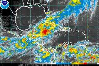
 All eyes will be on the tropics this weekend as we could see the first tropical system of the 2006 Atlantic hurricane season develop. The above image is a satellite picture taken Friday evening. You'll notice the flare up of thunderstorms in the northwestern Caribbean. This is an infrared satellite image, so the darker reds indicate colder cloud tops. Those colder cloud tops typically equate to stronger storms.
The National Hurricane Center (NHC) reported late this afternoon that pressures are falling in this area of disturbed weather, and that is an indication that this system may be getting stronger. The NHC has scheduled a hurricane hunter aircraft to fly into the storm Saturday afternoon to obtain more data.
Several forecast models bring this system into the Gulf of Mexico over the weekend and toward the U.S. Gulf coast. It is too early to say exactly how strong this system could become. It's also too early to say exactly where it may be headed. However, there is the possibility that it could impact the Gulf coast by early next week. If that is the case, it could then move northeast bringing rain to parts of the southeast.
There are a lot of "what ifs" with this system. Stay tuned to News 14 Carolina and we'll keep you posted with the latest. You can catch the latest tropical update at :21 after the hour every hour.

No comments:
Post a Comment