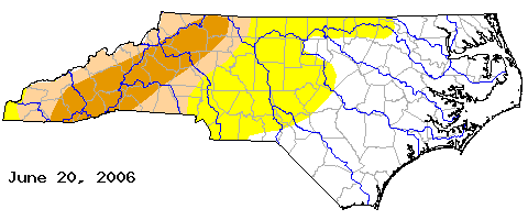
It appears we are in the midst of at least a temporary weather pattern shift from the drought to wet weather. Our friends over at the National Weather Service Forecast Office in Raleigh sent an e-mail to local meteorologists this week letting us know that we have had the second wettest June on record for RDU with 8.41" so far. The wettest June on record at RDU was in 1973 when the airport recorded 9.38" With about a week left in the month, we may top that total.
A front will approach North Carolina this weekend and will likely become stationary over our region Sunday and remain stalled out across the state through early next week. At the same time, a tropical wave now located northeast of the Bahamas will bring tropical moisture to the southeast by late in the weekend and early next week. That tropical moisture will interact with that stalled out front to give us an increased chance for showers and thunderstorms. Most of that activity would likely come during the heating of the day, or mainly during the afternoon and evening. With all that tropical moisture around, those showers and storms will likely produce heavy downpours.
Speaking of the tropical wave to the northeast of the Bahamas, the tropical outlook from the National Hurricane Center stated that pressures in that region of the tropics were beginning to drop. That can be the first sign of tropical development. The tropical wave is not looking very impressive on satellite this evening, and conditions are not too favorable for development tonight. However, that may change over the next day or so.
We'll keep you posted with the latest in our Weather on the Ones updates on News 14 Carolina. Stay tuned!

No comments:
Post a Comment