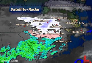
 At first glance of Friday's radar image, the answer would be -- yes, it was snowing. But, did you see any snow Friday afternoon? I didn't and mostly likely the only snow in North Carolina was in the form of isolated flurries in the mountains.
No, nothing was wrong with radars across the state Friday. There was precipitation falling from the clouds, but it was just too dry for any of that snow to reach the ground. Dewpoints at 4pm (same hour the radar image was captured from) were -4 in Raleigh-Durham, -6 in Greensboro, -7 in Fayetteville, and -13 in Winston-Salem. That's some dry air! All the snow from the clouds evaporated before we ever saw any of it.
So will we see any snow in the next few days? We will be watching a storm system that will spread precipitation across the state on Tuesday. As of now, it appears that most of that precipitation would be in the form of rain. As low pressure develops off our coast late Tuesday, it will draw some cooler air into our region. If there is still some precipitation around at that time, the precipitation may end as light sleet or a light wintry mix. It would probably be too light to cause any problems. However, if the track of this storm system is somewhat different than the current forecast, the precipitation that we see could be different.
We'll continue to monitor the latest weather data and keep you informed with the latest forecast. Just stay tuned for Weather on the Ones only on News 14 Carolina!

No comments:
Post a Comment