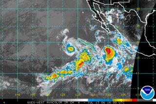
 The Atlantic hurricane season has been fairly quiet with only one named storm so far. There are no signs of tropical development in the Atlantic basin over the next few days, but that is a different story in the Pacific. The above satellite image from midday Thursday shows two hurricanes -- Hurricane Bud and Hurricane Carlotta.
As I write this blog midday Thursday along the east coast, Bud is the strongest of the two storms with maximum sustained winds around 115mph. That makes Bud a category 3 hurricane. Fortunately, both storms are located over the open waters of the Pacific and are not forecasted to affect land over the next 3 to 5 days.
You can find more on these storms including the latest forecast tracks by clicking to the National Hurricane Center's website at http://www.nhc.noaa.gov/
By the way, even though the Atlantic hurricane season seems to have been quiet so far, don't let that fool you. We typically do not see many storms in June and July, and the season will likely begin to pick up through August and September. Stay tuned...

No comments:
Post a Comment