As I write this blog post around 9pm Saturday evening, those storms are moving out of the News 14 Carolina viewing area. Most of us should stay partly cloudy and muggy for the overnight. A few isolated storms may fire up again Sunday afternoon.
Looking ahead to the new week, everyone will be talking about the heat and humidity. Afternoon highs will likely climb toward the mid to upper 90s on Monday and Tuesday. I wouldn't be too surpised if some neighborhoods especially in the Sandhills hit 100. It will certainly feel that way because of the humidity. Heat index values should range between 100 and 105 during the hottest part of the afternoon.
In the tropics this weekend, we've been keeping a close eye on two tropical waves, but neither are showings signs of development Saturday night.

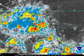
 The first satellite pictures shows one of the tropical waves over the eastern Caribbean. Showers and thunderstorms seemed to pick up with this wave during the day Saturday. It does not appear that conditions are favorable for any further development of this system at this time. At least one computer model shows this disturbance drifting closer to the Gulf of Mexico by early next week, so it will still need to be watched.
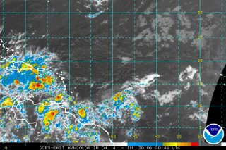
 The second satellite image shows the other tropical wave that we are keeping an eye on this weekend. This one does not appear as organized as it did Friday. Some slow development is still not out of the question for this system but does not appear likely at this time.

No comments:
Post a Comment