 Above is the state drought map updated this week. The darker shading represents "moderate drought" conditions. We've seen the moderate drought the last several weeks in southwestern North Carolina, but it has reappeared from the Triangle to the north. Our region has just not seen a good soaking rain recently. It appeared that we may have seen more widespread rain early this week, but that just did not pan out.
A lot of rains this time of year come in the form of scattered afternoon thunderstorms, so rain amounts have been hit or miss. The Raleigh-Durham Airport has measured over 2 inches of rain this month while the rain gauge at the National Weather Service Office on the NC State campus has measured less than half an inch.
We will not see any relief from the drought this weekend, but a front approaching the state next week will bring increased chances for rain especially on Tuesday and Wednesday.
You can read more about the drought in North Carolina by clicking to www.ncdrought.org.
Now to the big weather story of the weekend -- the tropics.
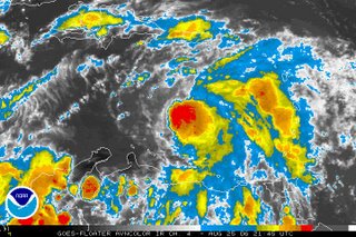
 Above is a satellite image of Tropical Storm Ernesto from Friday evening. A hurricane hunter aircraft found that the system had strengthened into a tropical storm this afternoon. Ernesto will encounter wind shear in the upper levels of the atmosphere over the next 24 hours. Wind shear typically hampers any strengthening and sometimes causes weakening. The official forecast calls for Ernesto to maintain its strength or strengthen only slightly through the first half of the weekend.
By Sunday, that wind shear should diminish and Ernesto will move into an area that will be favorable for strengthening. As it moves toward the western Caribbean, ocean waters are very warm and the storm could become a hurricane by early next week.
The next big concern is where will Ernesto go next week. Most computer models are in agreement that the storm will take a west-northwesterly track this weekend, but there is uncertainty on what will happen early next week. Here's a look at the forecast track from the National Hurricane Center as of Friday at 5pm:

The NHC is forecasting Ernesto to move into the central Gulf by Wednesday. Keep in mind there is a lot of uncertainty with this forecast, especially since Wednesday is 5 days away. The storm can be anywhere in the shaded area from that track map. It is way too early to say exactly where Ernesto may go, but with the storm forecast to move into the Gulf, residents along the Gulf coast will have to watch this one very closely this weekend. You can bet there are a lot of nervous Gulf coast residents considering this coming Tuesday will be the one year mark since Hurricane Katrina devastated the central Gulf coast.
One other note about Ernesto. The forecast calls for the storm to be at category one hurricane Wednesday, but the National Hurricane Center has pointed out there is uncertainty with that intensity forecast. Waters in the central Gulf are very warm, and it is quite possible that Ernesto could be much stronger.
The bottom line on Ernesto... it's way too early to panic on this storm. A lot could happen over the next several days, so stay tuned. We'll keep you up to date with tropical updates at :21 after the hour on News 14 Carolina. You can also find more online at www.nhc.noaa.gov
By the way, Tropical Storm Debby is still way out in the Atlantic and should remain out to sea not affecting land. With Ernesto potentially posing a threat to the Gulf coast next week, don't expect to hear much more about Debby.
Have a question about the hurricane season or the drought? Let us know in the comment section below.

No comments:
Post a Comment