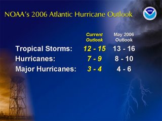
Over the last several days you may have read or heard news that hurricane forecasters have baked off their original forecast for the number of storms this year. While most forecasters have reduced the number of hurricanes expected this year, we should really take this information with a grain of salt. The forecast for the rest of the season still calls for an above average number of storms. Here's the latest forecast from NOAA --

Remember this is just a forecast for the number of storms that are expected to form in the Atlantic and does not say anything about the number of storms that may make landfall. Many meteorologists will bring up the year 1992 to make a point about forecasting the number of hurricanes. 1992 was a below average season in the number of hurricanes that formed. There were only six named storms that year, four of which became hurricanes. Sounds like a pretty quiet season, unless you remember that was the year that Hurricane Andrew made landfall in south Florida causing billions of dollars in damage.
No matter how many named storms or hurricanes are in the forecast, it only takes one to cause major damage along the United States coastline. We all have to remain alert through the end of the season.
You can read more about hurricane season and the forecasts for this year through the following links:
- NOAA Hurricane Forecast
- Tropical Cyclone Climatology
- 2005 Hurricane Season
- 1992 Hurricane Season
- Hurricane Andrew
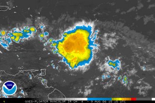
We also periodically discuss what is happening in the tropics here on our Weather on the Ones blog. As I write this blog Wednesday afternoon, a disturbance just east of the Windward Islands has caught our attention.
 This is a tropical wave that formed when it moved off the coast of Africa last week and moved to the west. Last night it appeared this wave had almost diminished all together. However, thunderstorms have flared up with the wave this morning. The National Hurricane Center has scheduled an Air Force Reserve Reconnaissance Aircraft to fly into the system this afternoon. We'll keep you posted on the latest. Again, for the latest tune to our tropical updates at :21 after the hour or check out the National Hurricane Center's website at www.nhc.noaa.gov

No comments:
Post a Comment