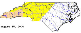
With no recent widespread rains, some dry conditions are returning to parts of North Carolina. Check out the latest state drought map from www.ncdrought.org:
 The yellow shade represents areas that are considered to be "abnormally dry." The darker shading in southwestern North Carolina represents moderate drought conditions.
While we are not facing those drought conditions right now in central North Carolina, a good soaking rain would be welcome. The National Weather Service in Raleigh pointed this out in their afternoon discussion today. I'll share with you some of the stats they mentioned in today's forecast discussion. Falls Lake, which is the water supply for Raleigh, has been falling about 0.1 foot for the past week and was nearly one foot below full pool as of Saturday morning. Rain totals from RDU don't seem so bad. Since the first of August, the airport has recorded 1.76", but most of that came from localized thunderstorms. Compare that to 0.18", which is the rainfall so far this month at the National Weather Service Office on NC State's Centennial Campus.
Typically summer rainfall in central North Carolina is scattered because most of our summer rains come in the form of pop-up thunderstorms. You can see the example of this in this month's rainfall difference between RDU and the NC State campus.
We have a different weather pattern setting up for late Sunday and early next week that could bring needed widespread rainfall. A cold front will move into the state Sunday bringing scattered afternoon showers and storms by late day. Most computer models show that front hanging up, or becoming stationary, across the region for Monday and Tuesday. That would keep mostly cloudy skies around along with off and on rain showers and a few thunderstorms in the forecast for the first couple days of the week. Some of the models from earlier today suggested as much as one to two inches of rain would be possible from Sunday through Tuesday. Exactly what spots will see that rainfall? It will all depend on exactly where that front stalls out. We will keep you posted. Watch News 14 Carolina for our Weather on the Ones updates!

No comments:
Post a Comment