
Happy new year from everyone in the Weather on the Ones Forecast Center! Thanks for counting on us this year for your latest weather information. We'll be here through 2007 keeping you informed with the most convenient forecast on television -- just tune in on the ones!
2007 is off to a wet start for North Carolina. Many spots can look for a half to one inch of rain from New Years Eve night through the first half of New Years Day.
The other weather story for the first week of January will be more mild weather. December was certainly warmer than we typically see around here, and we don't expect any changes for at least the first few days of January. Highs will likely reach the upper 50s to low 60s for Tuesday through the end of the week. The normal high this time of year is around 50.
Sunday, December 31, 2006
Friday, December 29, 2006
Wet Start to 2007
It still appears that 2007 will get off to a wet start in North Carolina. We've been tracking a strong storm across the U.S. the past few days. The storm is moving a little slower than originally anticipated, but should bring rain to our region late Sunday into New Year's Day.
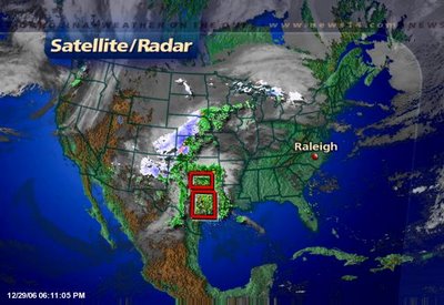
Today this storm system brought more snow to the Rockies including Denver and severe weather to Texas. As I write this post Friday evening, there have been 15 reports of tornadoes in Texas.
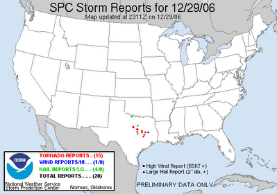 Some of these tornadoes have been big ones. A storm spotter reported a 1/4 mile wide tornado not too far from the Waco area Friday afternoon. Even President Bush and the First Lady had to seek shelter from a possible tornado near Crawford. No damage was reported near the President's ranch.
Look for more tornado reports Friday night through Saturday from East Texas through the Gulf Coast. You can find the latest on the severe weather threat from the Storm Prediction Center's website at www.spc.noaa.gov
As this storm moves to North Carolina, it will not pack quite the punch it has had in other parts of the country. We do not expect any severe weather in our region, but we will see rain. Look for a few spotty showers late Sunday with a better chance for rain late Sunday night into the first half of Monday. Many locations in central and eastern North Carolina could see about a half an inch of rain.
We'll keep you posted to the latest on this weekend's weather and how it may impact your New Years plans. Stay tuned to News 14 Carolina for Weather on the Ones updates.
Thursday, December 28, 2006
More Snow in Denver Could Mean a Rainy New Years Eve for North Carolina
It's a forecast the folks in Denver and air travelers don't want to hear -- more snow for the Rockies. 
The snow is falling in Denver this Thursday evening and will likely continue into Friday. Another foot of snow is possible. This is on top of all the snow that region saw just before Christmas.
The Denver blizzard just before Christmas eventually made its way across the U.S. and produced a rainy Christmas Day in the Carolinas. The current storm system over the Rockies will also slowly makes its way across the country and could give us a wet New Years Eve and New Years Day.
Before the storm gets to our part of the country, it will cross the south central U.S. where it could produce severe weather. 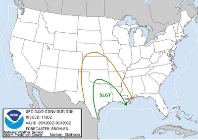
The Storms Prediction Center (www.spc.noaa.gov) has placed East Texas and parts of Louisiana under a "slight risk" for severe weather. Gusty winds, hail, and even tornadoes are a possibility late Friday night into Saturday from East Texas to the Gulf Coast states.
It's another big storm that could impact much of the U.S. Here in North Carolina, we do not expect any wintry weather and we do not expect any severe weather. However, a rain looks to be a good bet for your New Years Eve night plans. We'll keep you posted on this storm as it tracks closer to North Carolina. Stay tuned to News 14 Carolina for Weather on the Ones updates!
Wednesday, December 27, 2006
Warm December 2006
Much of December has been mild across North Carolina. In the Triangle, we are on track for 2006 to rank in the top 5 warmest Decembers on record. According to information from the National Weather Service, the monthly average temperature so far this December for Raleigh-Durham is 47.9F.
For comparison, here's a look at the five warmest monthly average temperatures for December at RDU since 1944:
For comparison, here's a look at the five warmest monthly average temperatures for December at RDU since 1944:
- 1956 -- 51.0F
- 1971 -- 50.3F
- 1984 -- 49.7F
- 1990 -- 48.1F
- 1982 -- 47.5F
The December "heat wave" has set at least one record this year. The high of 71 on December 17th broke the old record of 70 set in 2001. The warmest temperature of the month was 76 on December 18th, but that high did not break a record for the date.
While 2006 could go down as one of the five warmest Decembers, we have experienced a few cold nights and mornings. A record low was tied on December 9th when the temperature dropped to 16.
Friday, December 22, 2006
Last Minute Christmas Gift Idea
 If you're like me, you still have some of that last minute Christmas shopping to do. Here's an idea for that person on your list that seems to have everything. How about a NOAA weather radio? One of these radios is a must have for any home or business. I'd say its just as important as a smoke detector. Unfortunately, a lot of homes don't have one of these radios.
Some North Carolina residents learned about the importance of a weather radio earlier this year when a tornado devastated parts of Columbus County just before 7am in the morning. Columbus County residents were preparing for their day at work and getting their kids ready for the school day. Many were not tuned into a local news source to alert them of a tornado warning that had been issued for their hometown. If they had a weather radio in their home, it would have automatically sounded to alert them that they needed to take cover.
Think about it for a moment.... What if a tornado warning or another severe alert was issued in the middle of the night while you were sleeping? How would know that you and your family needed to take cover? NOAA weather radios can be programmed to sound an alarm when a warning is issued. You can even program the latest models of the radio to only sound an alarm when issued for your county.
Read more about weather radios and their features by clicking t0:
http://www.magazine.noaa.gov/stories/mag217.htm
You can find weather radios at most stores that sell other radios and electronics. It may be the perfect gift for someone that's still on your holiday shopping list, and it could be a life saver. Don't have one in your home already? It may be a good gift to give your household this year.
Thursday, December 21, 2006
White Christmas Dreams a Nightmare for Some
A lot of us here in North Carolina dream of a white Christmas. What could be better than waking up to winter wonderland on Christmas morning?
Folks in Denver and much of Colorado will wake up to a winter wonderland this Christmas Day, but trust me, it has been a nightmare for many folks. Here's a look at scenes from highways around Denver this morning --
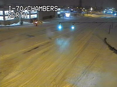
Folks in Denver and much of Colorado will wake up to a winter wonderland this Christmas Day, but trust me, it has been a nightmare for many folks. Here's a look at scenes from highways around Denver this morning --
 Highways are closed around the city, and even more importantly for holiday travelers, the airport is closed. As of this blog posting, the Denver airport will reopen midday Friday at the earliest. If you have family flying into town from or through Denver, they may not arrive for Christmas this year. Thousands of people are stranded at the airport, and they may not have a way out for a while. Read the latest news story from news14.com at this link:
http://rdu.news14.com/content/top_stories/default.asp?ArID=96821
By the way, this is part of the same storm system that will bring rain to North Carolina Friday and Saturday. There will be no snow for us, but one to two inches of rain will be possible. The heaviest of the rain looks to come Friday evening into the early morning hours Saturday.
Wednesday, December 20, 2006
From Dry Weather to Wet Weather
Up to this point in the month, December has been relatively dry for our part of North Carolina. Rainfall amounts so far this month are only 0.55" for Raleigh-Durham, 0.07" for Greensboro, and 0.19" for Fayetteville.
Just like our string of warm December days has come to an end, our string of dry days is about to come to an end.

Just like our string of warm December days has come to an end, our string of dry days is about to come to an end.
A large storm system is affecting much of the United States today. In addition to lots of rain, the storm is producing a lot of snow for some spots. Blizzard warnings are in effect for portions of Colorado.
Here's the view today from the Rocky Mountain National Park --

and the highways around Colorado Springs --
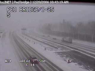
That storm system is slowly moving to the east, but we won't see any winter weather scenes like that around here. We likely will see our fair share of rain though. Early estimates suggest 1.0" to 1.5" of rain is possible from Friday through Saturday in central and eastern North Carolina.
In our extended forecast, we should get a break from the rain during the day Christmas Eve, but the rain looks to return for Christmas Day.
No white Christmas for us.... just a wet one.
We'll keep you updated with the latest forecast as prepare for the holidays, so stay tuned to Weather on the Ones on News 14 Carolina for updates!
Sunday, December 17, 2006
Dreaming of a White Christmas?
Christmas Day is almost here and a lot of folks are asking about the possibilities for a White Christmas. A White Christmas looks unlikely for our part of the world this year. In fact a White Christmas is very rare for our part of North Carolina.
The last White Christmas for Raleigh was in 1966 when there was an inch of snow on the ground from a previous snowfall. Since 1948, no more than a trace of snow has fallen on Christmas Day in Raleigh.
The Triad had its last White Christmas in 1969 when 1.1" of snow was reported in Greensboro.
Southeastern North Carolina has experienced a more recent White Christmas than the Triangle or the Triad. Some folks may remember the record breaking snowfall just before Christmas Day 1989. That storm produced over a foot of snow for Wilmington. On Christmas Day 1989, there was still 13" of snow on the ground in Wilmington and 2" in Fayetteville.
You can find more information on Christmas Day climate across North Carolina from the State Climate Office of North Carolina. Check out these links --
Record Breaking Sunday
Temperatures were warm enough Sunday to set a new record high temperature for Raleigh-Durham and for Greensboro. The high topped out at 71 around 3pm at the RDU airport breaking the old record of 70 set in 2001. In Greensboro, the high reached 69 breaking the old record of 68 set in 1933.
Here's a look at other Sunday afternoon highs from around the region --
Here's a look at other Sunday afternoon highs from around the region --
- Henderson-Oxford: 73
- Lexington: 73
- Lumberton: 73
- Asheboro: 72
- Fayetteville : 72
- Goldsboro: 72
- Smithfield: 72
- Chapel Hill: 70
- Louisburg: 70
- Southern Pines: 70
- Burlington: 69
- Rocky Mount-Wilson: 68
- Winston-Salem: 68
- Mount Airy: 66
Monday will bring another warm day to North Carolina. Most of us should reach highs in the low 70s, but we do not expect to set any records. Monday's records stand at 77 for Raleigh-Durham and 75 for Greensboro.
Saturday, December 16, 2006
Could we set a record Sunday?
It has not felt much like the holiday season the last few days. If you're thinking it has been unusually warm, you are right! Our normal highs this time of year are in the low to mid 50s, so highs in the 60s are above what we average for mid-December.
This December "heat wave" will continue for the rest of the weekend and into early next week. In fact, we will come very close to record highs on Sunday. The records are 70 set in 2001 for Raleigh-Durham and 68 set in 1993 for Greensboro. 2006 may go in the record books tomorrow as we expect afternoon temperatures to reach near 70 in the Triangle and the upper 60s for the Triad.
Monday may even be warmer than Sunday with highs forecast to reach in the low 70s in some spots. However, we do not expect to set any records for Monday. Record highs for December 18 stand at 77 for Raleigh-Durham and 75 for Greensboro.
This warm weather can't last forever though. Afternoon temperatures should be closer to normal by the middle and end of the upcoming work week, and the warm weather shouldn't return for Christmas. As it stands now, Christmas day should bring near normal to below normal temperatures. We'll keep you posted.
Friday, December 15, 2006
Northern Lights

The electromagnetic storm that we mentioned yesterday produced beautiful sights in some parts of the United States last night. There were numerous reports in northern parts of our country of the northern lights.
You can see photos of the Northern Lights by clicking to
http://www.spaceweather.com/aurora/gallery_01dec06_page2.htm
You can also read more about the Northern Lights at http://www.spaceweather.com/
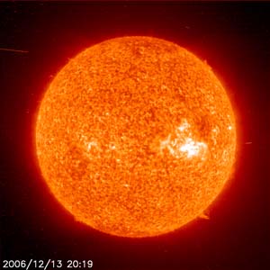
Thursday, December 14, 2006
Space Weather Event

Subscribe to:
Posts (Atom)