Sunday, August 31, 2008

Gustav remains a major hurricane, heads toward the U.S. Gulf Coast

We're watching Hurricane Gustav as well as Tropical Storm Hanna this weekend and into next week.
Gustav has weakened somewhat after passing over Cuba but is expected to maintain at least a category 3 (sustained winds of 111mph - 130mph) strength as it approaches our Gulf coast Monday. There may be some strengthening as this storm passes over the Gulf Loop Current (which if you remember the summer of Katrina and Rita, you heard a lot about it!) The National Hurricane Center is forecasting Gustav to make landfall as a Major Hurricane on Monday.

The track of Gustav (as of 5am Sunday) bring the center of circulation squarely upon central Louisiana, which puts Northeastern, Eastern Louisiana as well as Western Mississippi on the right side (the more powerful side) of the storm's path.


Tropical Storm Hanna remains a Tropical Storm through the rest of our holiday weekend, but will start to affect our coast with swells later today which would create dangerous rip currents.
Forecast models have been changing Hanna's path to reflect a more eastern component to the forecast track later next week which could bring Hanna to the SE Coast of the U.S. instead of the Caribbean and Gulf. That means we're watching this even more in your Weather on the Ones Forecast Center since Hanna may be affecting our weather into next weekend.


Gustav Powerful Category 4!

Major Hurricane Gustav continues to defy original thought and gains strength in the Gulf of Mexico. When Gustav originally developed many through this storm would reach Category 3 and flat line, but Saturday afternoon Gustav was just 5mph away from becoming the first Category 5 of the 2008 Atlantic Hurricane Season.


Infrared Satellite imagery shows a deep low with a clearly defined center of circulation. The eye wall passed over Western Cuba late Saturday evening and emerged in the Gulf relatively unscathed. I believe we'll see Gustav become a Category 5 at some point on Sunday before slowly weakening some before a catastrophic collision with the Gulf Coast. Right now Louisiana appears to be vulnerable to Gustav and residents of The Pelican State are on edge. Evacuations have been ordered in New Orleans as the city is attempting to prevent scenes similar to those just three years ago when Katrina made landfall. Eerily enough the third anniversary of Katrina's landfall was Friday, August 29. Now, we're on the verge of another dangerous and destructive hurricane striking anywhere from Biloxi, Mississippi to Lake Charles, Louisiana during the day Monday.


Saturday, August 30, 2008

Gustav a Major Hurricane; Could Briefly Reach cat. 4

The National Hurricane Center confirmed this morning that Gustav reached Category three status , and more strengthening is expected after passing over Cuba today and tonight.

From the National Hurricane Center:
"...GUSTAV IS MOVING TOWARD THE NORTHWEST NEAR 14 MPH...22 KM/HR...ANDTHIS GENERAL MOTION IS EXPECTED TO CONTINUE DURING THE NEXT COUPLEOF DAYS. ON THIS TRACK...THE CENTER OF GUSTAV WILL PASS OVERWESTERN PORTIONS OF CUBA TODAY AND TONIGHT...EMERGE OVER THE SOUTHERN GULF OF MEXICO EARLY ON SUNDAY...AND REACH THE NORTHERNGULF BY MONDAY MORNING.MAXIMUM SUSTAINED WINDS ARE NEAR 125 MPH...205 KM/HR...WITH HIGHER GUSTS. GUSTAV IS A CATEGORY THREE HURRICANE ON THE SAFFIR-SIMPSONSCALE. FLUCTUATIONS IN STRENGTH ARE POSSIBLE DURING THE NEXT 24HOURS AS GUSTAV PASSES NEAR AND OVER WESTERN CUBA. ADDITIONALSTRENGTHENING IS FORECAST AFTER GUSTAV REACHES THE GULF OF MEXICO.


THE NEW OFFICIAL FORECAST TRACK REMAINS CONSISTENT WITH THE REMAINING GUIDANCE IN TAKING GUSTAV INLAND IN LESS THAN 72 HOURS...AND IS JUST EDGED EVER SO SLIGHTLY TO THE RIGHT...IN PART TO ACCOUNT FORTHE RECENT RIGHT OF TRACK MOTION. REGARDLESS OF THE DETAILS IN THE TRACK...GUSTAV WILL LIKELY SLOW DOWN SIGNIFICANTLY IN THE LONGER-TERM...WHICH COULD CAUSE A CONSIDERABLE FLOODING THREAT OVERLOUISIANA AND TEXAS."


And regarding Tropical Storm Hanna:


From the National Hurricane Center:
"...BASED ON THE NEW FORECAST TRACK...THE GOVERNMENT OF THE BAHAMAS HAS ISSUED A TROPICAL STORM WATCH FOR THE SOUTHEASTERN BAHAMAS AND TURKS AND CAICOS ISLANDS.
AT 1100 AM AST...1500Z...THE CENTER OF TROPICAL STORM HANNA WASLOCATED NEAR LATITUDE 21.9 NORTH...LONGITUDE 66.4 WEST OR ABOUT 305MILES...490 KM...EAST OF GRAND TURK ISLAND.HANNA IS MOVING TOWARD THE WEST NEAR 8 MPH...13 KM/HR. A WEST TOWEST-NORTHWESTWARD MOTION WITH A GRADUAL DECREASE IN FORWARD SPEED IS FORECAST DURING THE NEXT COUPLE OF DAYS. ON THIS TRACK...THE CENTER OF HANNA IS FORECAST TO MOVE NEAR OR JUST NORTHEAST OF THE TURKS AND CAICOS ISLANDS LATE SUNDAY OR EARLY MONDAY.MAXIMUM SUSTAINED WINDS ARE NEAR 50 MPH...85 KM/HR...WITH HIGHER GUSTS. SOME GRADUAL STRENGTHENING IS FORECAST DURING THE NEXT DAY OR TWO.
LONG-PERIOD SWELLS FROM HANNA ARE EXPECTED TO INCREASE THE RISK OF DANGEROUS RIP CURRENTS ALONG PORTIONS OF THE SOUTHEASTERN UNITED STATES COAST DURING THE NEXT COUPLE OF DAYS..."

Tuesday, August 26, 2008

Fay Brings Rain to North Carolina and Tracking Gustav...

Parts of North Carolina could see between 1 and 3 inches of rain over the next couple of days as remnant moisture from Fay interacts with a frontal boundary across the Carolinas. In addition to our rain chances, we're also tracking newly formed Hurricane Gustav. Find our more in this morning's video blog posted below...

Saturday, August 23, 2008

Looks like moisture from Fay still headed our way

In today's video blog, we see that high rpessure will continue to bring us nice weather for our weekend, but an approaching cold front will tap into moisture from Tropical Storm Fay and bring us a good possibility for some showers and storms during the week.


Friday, August 22, 2008

Fay Update -- Friday Morning


Tropical Storm Fay is still alive this Friday morning battering northern Florida with winds up to 45mph and heavy rains. Portions of northern Florida and southern Georgia could see up to 5 to 10 inches of rain from the storm . Localized areas could see even more.

Fay will slowly move along the Gulf Coast this weekend as it gradually weakens. Eventually, some remnant moisture from Fay should work its way back to the east toward the Carolinas. This will enhance our rain chances for the middle of next week. In fact, we may see a few showers and thunderstorms as early as late Monday. However, our rain chances should be higher for Tuesday through Thursday.

Elsewhere, there is more activity to watch in the tropics. Here's a look at what the National Hurricane Center is watching today....


The disturbances labeled 1 and 2 both have a medium chance for some slow development over the coming days. Stay tuned to News 14 Carolina for Weather on the Ones updates through the weekend for the latest...

Thursday, August 21, 2008

Fay Update -- Thursday Morning


Tropical Storm Fay is nearly stationary this morning off Flordia's northeast coast. The storm should slowly move to the west later today spreading heavy rain and wind across north Florida and south Georgia. Check out this morning's video blog update posted below for more...


Stay tuned to News 14 Carolina for our tropical updates at :21 after the hour.

Wednesday, August 20, 2008

Fay Update -- Wednesday Morning


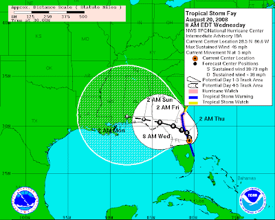
Tropical Storm Fay is located along the east coast of Florida this morning and it could briefly spend some time in the Atlantic later today. If the storm is able to get offshore, it may strengthen some before making landfall again across northern Florida.

High pressure to the north of North Carolina should still keep Fay away from North Carolina. Find out more in this morning's video blog update posted below...


Tuesday, August 19, 2008

Evening Update

Fay Update -- Tuesday Morning


The last 24 hours have featured some pretty significant changes int he forecast for Tropical Storm Fay. Find out more in this morning's video blog update posted below...

Stay tuned to News 14 Carolina for tropical updates at :21 after the hour every hour.


Monday, August 18, 2008

Fay Update -- Monday Morning

Tropical Storm Fay is strengthening some this morning as it emerges off the coast of Cuba


Friday, August 15, 2008

Fay is Here

Tropical Storm Fay formed this afternoon near Hispanola. The latest computer guidance this today has taken a westward shift compared to what has been discussed in our video blog the past few entires. As of Friday evening, here is the latest forecast for Fay from the National Hurricane Center...
Stay tuned for our tropical updates at :21 after the hour on News 14 Carolina.

Tropical Update -- Friday Morning


We continue to watch a tropical disturbance today located near Puerto Rico. This disturbance has the potential to become our next tropical storm over the weekend. Find out more in this morning's video blog update posted below...


Thursday, August 14, 2008

Next tropical depression brewing?


The next tropical depression of the 2008 Atlantic season could develop later today or tomorrow. Find out more in this morning's video blog update posted below...


Tuesday, August 12, 2008

Rainy Day Possible for Wednesday...

We're watching an area of low pressure that will track across South Carolina and up the North Carolina coast on Wednesday. That low will bring us wet weather along with unusually cool temperatures for August. We're also tracking a couple of disturbances in the tropics today. Find out more on Wednesday's unusual storm system and the tropics in this morning's video blog update posted below...

Friday, August 08, 2008

Friday Morning Update


Storms rocked parts of the Sandhills with damaging winds, hail, lightning, and downpours yesterday, but pleasant weather has arrived in time for the weekend. Find out more about yesterday's storms and this weekend's forecast in this morning's video blog update posted below...


Thursday, August 07, 2008

Chance for Storms Thursday Afternoon

There is a slight risk for strong to severe storms across our area this afternoon. For more on today's threat for storms, check out this morning's video blog update posted below...


Monday, August 04, 2008

Summer Heat and Tracking Eduoard

Two weather stories of note today.... a mini-heat wave for our area this week and a tropical storm in the Gulf of Mexico. For more, check out this morning's video blog update posted below...