
Happy new year from everyone in the Weather on the Ones Forecast Center! Thanks for counting on us this year for your latest weather information. We'll be here through 2007 keeping you informed with the most convenient forecast on television -- just tune in on the ones!
2007 is off to a wet start for North Carolina. Many spots can look for a half to one inch of rain from New Years Eve night through the first half of New Years Day.
The other weather story for the first week of January will be more mild weather. December was certainly warmer than we typically see around here, and we don't expect any changes for at least the first few days of January. Highs will likely reach the upper 50s to low 60s for Tuesday through the end of the week. The normal high this time of year is around 50.
Sunday, December 31, 2006
Friday, December 29, 2006
Wet Start to 2007
It still appears that 2007 will get off to a wet start in North Carolina. We've been tracking a strong storm across the U.S. the past few days. The storm is moving a little slower than originally anticipated, but should bring rain to our region late Sunday into New Year's Day.
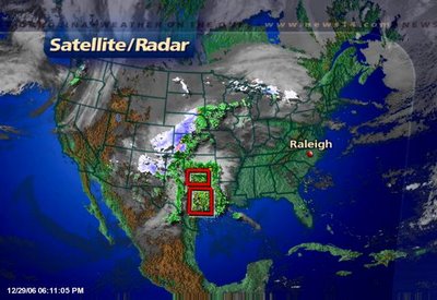
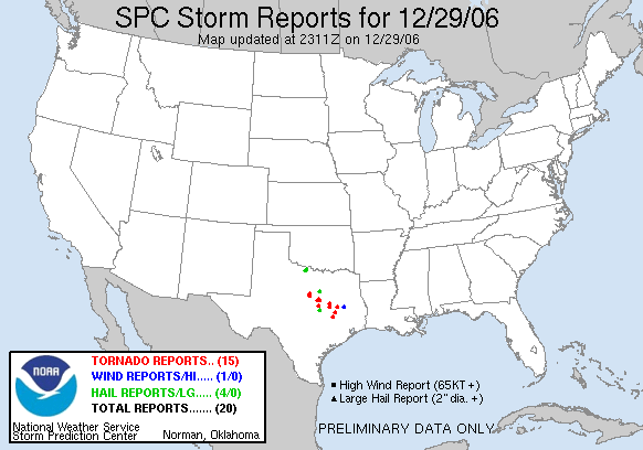
Today this storm system brought more snow to the Rockies including Denver and severe weather to Texas. As I write this post Friday evening, there have been 15 reports of tornadoes in Texas.
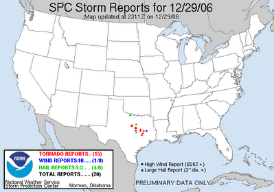 Some of these tornadoes have been big ones. A storm spotter reported a 1/4 mile wide tornado not too far from the Waco area Friday afternoon. Even President Bush and the First Lady had to seek shelter from a possible tornado near Crawford. No damage was reported near the President's ranch.
Look for more tornado reports Friday night through Saturday from East Texas through the Gulf Coast. You can find the latest on the severe weather threat from the Storm Prediction Center's website at www.spc.noaa.gov
As this storm moves to North Carolina, it will not pack quite the punch it has had in other parts of the country. We do not expect any severe weather in our region, but we will see rain. Look for a few spotty showers late Sunday with a better chance for rain late Sunday night into the first half of Monday. Many locations in central and eastern North Carolina could see about a half an inch of rain.
We'll keep you posted to the latest on this weekend's weather and how it may impact your New Years plans. Stay tuned to News 14 Carolina for Weather on the Ones updates.
Thursday, December 28, 2006
More Snow in Denver Could Mean a Rainy New Years Eve for North Carolina
It's a forecast the folks in Denver and air travelers don't want to hear -- more snow for the Rockies. 
The snow is falling in Denver this Thursday evening and will likely continue into Friday. Another foot of snow is possible. This is on top of all the snow that region saw just before Christmas.
The Denver blizzard just before Christmas eventually made its way across the U.S. and produced a rainy Christmas Day in the Carolinas. The current storm system over the Rockies will also slowly makes its way across the country and could give us a wet New Years Eve and New Years Day.
Before the storm gets to our part of the country, it will cross the south central U.S. where it could produce severe weather. 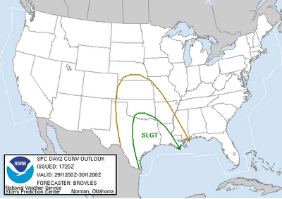
The Storms Prediction Center (www.spc.noaa.gov) has placed East Texas and parts of Louisiana under a "slight risk" for severe weather. Gusty winds, hail, and even tornadoes are a possibility late Friday night into Saturday from East Texas to the Gulf Coast states.
It's another big storm that could impact much of the U.S. Here in North Carolina, we do not expect any wintry weather and we do not expect any severe weather. However, a rain looks to be a good bet for your New Years Eve night plans. We'll keep you posted on this storm as it tracks closer to North Carolina. Stay tuned to News 14 Carolina for Weather on the Ones updates!
Wednesday, December 27, 2006
Warm December 2006
Much of December has been mild across North Carolina. In the Triangle, we are on track for 2006 to rank in the top 5 warmest Decembers on record. According to information from the National Weather Service, the monthly average temperature so far this December for Raleigh-Durham is 47.9F.
For comparison, here's a look at the five warmest monthly average temperatures for December at RDU since 1944:
For comparison, here's a look at the five warmest monthly average temperatures for December at RDU since 1944:
- 1956 -- 51.0F
- 1971 -- 50.3F
- 1984 -- 49.7F
- 1990 -- 48.1F
- 1982 -- 47.5F
The December "heat wave" has set at least one record this year. The high of 71 on December 17th broke the old record of 70 set in 2001. The warmest temperature of the month was 76 on December 18th, but that high did not break a record for the date.
While 2006 could go down as one of the five warmest Decembers, we have experienced a few cold nights and mornings. A record low was tied on December 9th when the temperature dropped to 16.
Friday, December 22, 2006
Last Minute Christmas Gift Idea
 If you're like me, you still have some of that last minute Christmas shopping to do. Here's an idea for that person on your list that seems to have everything. How about a NOAA weather radio? One of these radios is a must have for any home or business. I'd say its just as important as a smoke detector. Unfortunately, a lot of homes don't have one of these radios.
Some North Carolina residents learned about the importance of a weather radio earlier this year when a tornado devastated parts of Columbus County just before 7am in the morning. Columbus County residents were preparing for their day at work and getting their kids ready for the school day. Many were not tuned into a local news source to alert them of a tornado warning that had been issued for their hometown. If they had a weather radio in their home, it would have automatically sounded to alert them that they needed to take cover.
Think about it for a moment.... What if a tornado warning or another severe alert was issued in the middle of the night while you were sleeping? How would know that you and your family needed to take cover? NOAA weather radios can be programmed to sound an alarm when a warning is issued. You can even program the latest models of the radio to only sound an alarm when issued for your county.
Read more about weather radios and their features by clicking t0:
http://www.magazine.noaa.gov/stories/mag217.htm
You can find weather radios at most stores that sell other radios and electronics. It may be the perfect gift for someone that's still on your holiday shopping list, and it could be a life saver. Don't have one in your home already? It may be a good gift to give your household this year.
Thursday, December 21, 2006
White Christmas Dreams a Nightmare for Some
A lot of us here in North Carolina dream of a white Christmas. What could be better than waking up to winter wonderland on Christmas morning?
Folks in Denver and much of Colorado will wake up to a winter wonderland this Christmas Day, but trust me, it has been a nightmare for many folks. Here's a look at scenes from highways around Denver this morning --
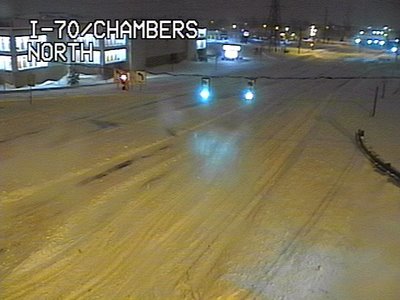
Folks in Denver and much of Colorado will wake up to a winter wonderland this Christmas Day, but trust me, it has been a nightmare for many folks. Here's a look at scenes from highways around Denver this morning --
 Highways are closed around the city, and even more importantly for holiday travelers, the airport is closed. As of this blog posting, the Denver airport will reopen midday Friday at the earliest. If you have family flying into town from or through Denver, they may not arrive for Christmas this year. Thousands of people are stranded at the airport, and they may not have a way out for a while. Read the latest news story from news14.com at this link:
http://rdu.news14.com/content/top_stories/default.asp?ArID=96821
By the way, this is part of the same storm system that will bring rain to North Carolina Friday and Saturday. There will be no snow for us, but one to two inches of rain will be possible. The heaviest of the rain looks to come Friday evening into the early morning hours Saturday.
Wednesday, December 20, 2006
From Dry Weather to Wet Weather
Up to this point in the month, December has been relatively dry for our part of North Carolina. Rainfall amounts so far this month are only 0.55" for Raleigh-Durham, 0.07" for Greensboro, and 0.19" for Fayetteville.
Just like our string of warm December days has come to an end, our string of dry days is about to come to an end.

Just like our string of warm December days has come to an end, our string of dry days is about to come to an end.
A large storm system is affecting much of the United States today. In addition to lots of rain, the storm is producing a lot of snow for some spots. Blizzard warnings are in effect for portions of Colorado.
Here's the view today from the Rocky Mountain National Park --

and the highways around Colorado Springs --
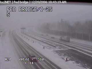
That storm system is slowly moving to the east, but we won't see any winter weather scenes like that around here. We likely will see our fair share of rain though. Early estimates suggest 1.0" to 1.5" of rain is possible from Friday through Saturday in central and eastern North Carolina.
In our extended forecast, we should get a break from the rain during the day Christmas Eve, but the rain looks to return for Christmas Day.
No white Christmas for us.... just a wet one.
We'll keep you updated with the latest forecast as prepare for the holidays, so stay tuned to Weather on the Ones on News 14 Carolina for updates!
Sunday, December 17, 2006
Dreaming of a White Christmas?
Christmas Day is almost here and a lot of folks are asking about the possibilities for a White Christmas. A White Christmas looks unlikely for our part of the world this year. In fact a White Christmas is very rare for our part of North Carolina.
The last White Christmas for Raleigh was in 1966 when there was an inch of snow on the ground from a previous snowfall. Since 1948, no more than a trace of snow has fallen on Christmas Day in Raleigh.
The Triad had its last White Christmas in 1969 when 1.1" of snow was reported in Greensboro.
Southeastern North Carolina has experienced a more recent White Christmas than the Triangle or the Triad. Some folks may remember the record breaking snowfall just before Christmas Day 1989. That storm produced over a foot of snow for Wilmington. On Christmas Day 1989, there was still 13" of snow on the ground in Wilmington and 2" in Fayetteville.
You can find more information on Christmas Day climate across North Carolina from the State Climate Office of North Carolina. Check out these links --
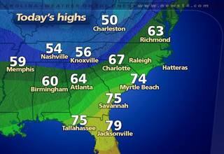
Record Breaking Sunday
Temperatures were warm enough Sunday to set a new record high temperature for Raleigh-Durham and for Greensboro. The high topped out at 71 around 3pm at the RDU airport breaking the old record of 70 set in 2001. In Greensboro, the high reached 69 breaking the old record of 68 set in 1933.
Here's a look at other Sunday afternoon highs from around the region --
Here's a look at other Sunday afternoon highs from around the region --
- Henderson-Oxford: 73
- Lexington: 73
- Lumberton: 73
- Asheboro: 72
- Fayetteville : 72
- Goldsboro: 72
- Smithfield: 72
- Chapel Hill: 70
- Louisburg: 70
- Southern Pines: 70
- Burlington: 69
- Rocky Mount-Wilson: 68
- Winston-Salem: 68
- Mount Airy: 66
Monday will bring another warm day to North Carolina. Most of us should reach highs in the low 70s, but we do not expect to set any records. Monday's records stand at 77 for Raleigh-Durham and 75 for Greensboro.
Saturday, December 16, 2006
Could we set a record Sunday?
It has not felt much like the holiday season the last few days. If you're thinking it has been unusually warm, you are right! Our normal highs this time of year are in the low to mid 50s, so highs in the 60s are above what we average for mid-December.
This December "heat wave" will continue for the rest of the weekend and into early next week. In fact, we will come very close to record highs on Sunday. The records are 70 set in 2001 for Raleigh-Durham and 68 set in 1993 for Greensboro. 2006 may go in the record books tomorrow as we expect afternoon temperatures to reach near 70 in the Triangle and the upper 60s for the Triad.
Monday may even be warmer than Sunday with highs forecast to reach in the low 70s in some spots. However, we do not expect to set any records for Monday. Record highs for December 18 stand at 77 for Raleigh-Durham and 75 for Greensboro.
This warm weather can't last forever though. Afternoon temperatures should be closer to normal by the middle and end of the upcoming work week, and the warm weather shouldn't return for Christmas. As it stands now, Christmas day should bring near normal to below normal temperatures. We'll keep you posted.
Friday, December 15, 2006
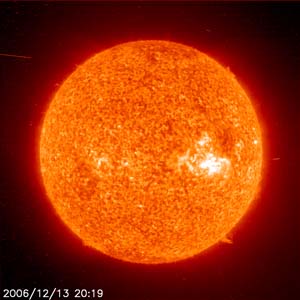
Northern Lights

The electromagnetic storm that we mentioned yesterday produced beautiful sights in some parts of the United States last night. There were numerous reports in northern parts of our country of the northern lights.
You can see photos of the Northern Lights by clicking to
http://www.spaceweather.com/aurora/gallery_01dec06_page2.htm
You can also read more about the Northern Lights at http://www.spaceweather.com/
Thursday, December 14, 2006
Space Weather Event

Thursday, November 30, 2006
Record High Set at RDU
The record high was broken Thursday at Raleigh-Durham International Airport. The temperature reached 77 at 1:39pm this afternoon. The previous record was 76 set in 1998.
Another Mild Day
We didn't quite break any records Wednesday across central North Carolina, but we did come close. The high topped out at 75 yesterday at Raleigh-Durham. The record stands at 77 set in 2001. In the Triad, the high reach 70 compared to the record of 75 also set in 2001.
We have another chance to break a record today. Thursday's records stand at 76 set in 1998 for Raleigh-Durham and 74 set in 1991 for Greensboro. As of midday, we are very close to those records.
This unusually warm weather can't last forever. It is almost December, after all! Changing weather is on the horizon. Take a look at the cold air across the western United States --
Temperatures from midday Thursday.
Along the leading edge of that cold air we have quite a storm system marching across the United States. Some strong storms are possible this afternoon in parts of the southeast, and snow is falling from Texas to Oklahoma to Missouri.
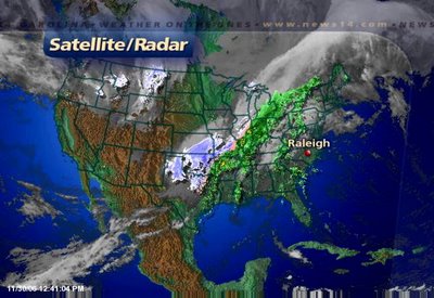
Satellite/radar composite from midday Thursday.
This storm will not bring wintry weather to North Carolina, but it will bring rain for Friday with the chance for a few thunderstorms. If thunderstorms develop along the cold front, a few could produce gusty winds. Because of the small threat for damaging winds, the Storms Prediction Center has placed parts of North Carolina under a "slight risk" for severe weather.
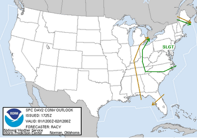
Severe weather outlook for Friday.
We'll keep you posted through the day on Friday in the event any strong storms do form. Count on News 14 Carolina for the very latest weather information every 10 minutes with Weather on the Ones.
The cooler air arrives this weekend. While the coldest air won't makes its way into the Carolinas, we will notice a difference in the temperatures. Highs will only reach the 50s on Saturday and Sunday with morning lows in the 30s.
Wednesday, November 29, 2006
Enjoying the warm weather?
 Midday temperatures from Wednesday.
 As I write this blog post, the 1pm temperature at the Raleigh-Durham airport is 75 -- just 2 degrees away from the record high of 77. That record was set in 2001. We may end up putting 2006 in the record books for the high. We'll keep you posted.
While we are enjoying temperatures in the 70s this afternoon, Denver is in the teens! That colder air out west will eventually headed our way. We won't see temperatures nearly that cold, but by the weekend our afternoon temperatures will only top out in the 50s. By next week, morning lows could reach the upper 20s.
Before the cooler air arrives, showers and thunderstorms will move across the state on Friday. Some of the thunderstorms could produce gusty winds Friday midday through the afternoon.
Thursday, November 23, 2006
Improving Weather
Much better weather is on the way through the rest of this extended holiday weekend. The coastal low that brought wet and windy weather to much of North Carolina is spreading rain across the northeastern U.S. this Thanksgiving, but is moving a long ways away from North Carolina. Sun will return for all of us Friday.
Here's a look back at rain totals from this week's Nor'easter--
Here's a look back at rain totals from this week's Nor'easter--
- Fayetteville: 4.26"
- Lumberton: 3.21"
- Burlington: 3.16"
- Chapel Hill: 2.71"
- Raleigh-Durham: 2.71"
- Southern Pines: 2.67"
- Greensboro: 1.98"
- Winston-Salem: 1.43"
Now look for milder weather with highs climbing toward the upper 60s and near 70 by Sunday.
Monday, November 20, 2006
Snow in the Mountains
The first snow of the season can be seen in the mountains today --
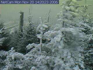 Webcam image from Mount Mitchell around 2pm Monday.
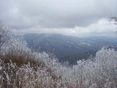 Webcam image from Shining Rock Wilderness looking toward Cold Mountain around 2pm Monday.
Webcam image from Mount Mitchell around 2pm Monday.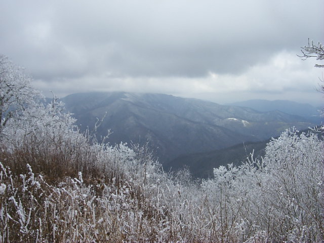 Webcam image from Shining Rock Wilderness looking toward Cold Mountain around 2pm Monday.
Now our attention turns to the coastal low developing off the Carolina coast. Gale warnings are up along the Outer Banks. The forecast remains a very wet one leading into Thanksgiving for the eastern half of North Carolina. We'll keep you posted with the latest. Stay tuned to News 14 Carolina!
Sunday, November 19, 2006
Snow Possible in the Mountains and a Coastal Storm Brewing
We have an interesting weather set up across North Carolina as we head into Thanksgiving week.
As I type this post, a snow advisory is in effect along the North Carolina-Tennessee border. The Smokey Mountains could see their first snowfall of the season. One to three inches of snow are possible late Sunday night and Monday morning in the higher elevations.
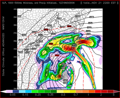
Elsewhere the big weather story this week in the state will be a coastal storm that could cause some problems as we get ready for the Thanksgiving holiday. This low pressure will develop off the South Carolina and Georgia coast Monday. The latest model data coming in this evening suggests this low may form closer to the coast than first indicated. This means more of an impact on our weather in the Triangle, the Sandhills, and possibly the Triad.
Here's a look at one computer model run by the State Climate Office of North Carolina for Tuesday night --
As I type this post, a snow advisory is in effect along the North Carolina-Tennessee border. The Smokey Mountains could see their first snowfall of the season. One to three inches of snow are possible late Sunday night and Monday morning in the higher elevations.
Elsewhere the big weather story this week in the state will be a coastal storm that could cause some problems as we get ready for the Thanksgiving holiday. This low pressure will develop off the South Carolina and Georgia coast Monday. The latest model data coming in this evening suggests this low may form closer to the coast than first indicated. This means more of an impact on our weather in the Triangle, the Sandhills, and possibly the Triad.
Here's a look at one computer model run by the State Climate Office of North Carolina for Tuesday night --
At this time, it appears rain will start spreading into our part of the state during the day Tuesday. With the low off our coast, our winds will come from the northeast keeping us cool and breezy. Afternoon temperatures will likely not make it out of the 40s on Tuesday.
The low will be slow to move away from the coast, so for now, rain is also in our forecast for Wednesday into early Thanksgiving. Wednesday will not be the best day for travel especially across the eastern half of the state. Rain, cool, and breezy conditions will not make for ideal travel conditions. Again on Wednesday, temperatures will likely only warm to the 40s.
The worst of the weather from this storm will come along our coastline, particularly along the Outer Banks where winds of 40mph or greater will be possible. Coastal flooding and erosion could be a problem.
Stay with News 14 Carolina this week for the latest developments on this coastal low. As always, we're the only place to turn for local weather updates every 10 minutes with Weather on the Ones.
Saturday, November 18, 2006
Tornadoes in November
This week we had a clear reminder -- severe weather can happen any time of the year. Although we typically have more severe weather in the spring, there is really no "tornado season" like we have a "hurricane season."
In fact, some of the worst tornadoes in our state's recent history have occurred during the month of November.
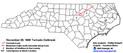
In fact, some of the worst tornadoes in our state's recent history have occurred during the month of November.
If you lived in Raleigh in 1988, you'll remember the above event. An F4 tornado developed over Wake County the Sunday night/Monday morning after Thanksgiving. The tornado stayed on the ground for 84 miles traveling from north Raleigh to near the Virginia border. Four people were killed and 157 were injured. A K-Mart located off of Glenwood Avenue was just one of 78 businesses destroyed. 425 homes were destroyed. Over 2000 homes sustained some type of damage.
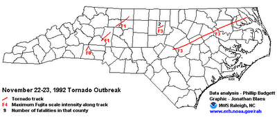
Another deadly tornado outbreak occurred in 1992. From the night of November 22 through the early morning of November 23, five tornadoes killed two people and injured 74 in North Carolina. During the 1992 outbreak, an F3 touched down near the I-40/85 split in Orange County and moved toward Hillsborough. Another F3 touched down near the Harnett/Johnston County line and moved northeast for 160 miles. That is the longest track tornado on record for North Carolina.
Unfortunately, we now have to add 2006 to the list of deadly November tornadoes in North Carolina.
Read more about November tornadoes in our state by clicking to these links --
Friday, November 17, 2006
Thursday's Tornadoes
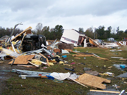 Photo courtesy Whiteville News Reporter
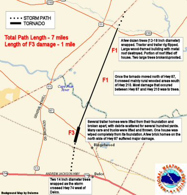
Columbus County tornado path. Graphic from National Weather Service - Wilmington.
The National Weather Service in Wilmington has released their official storm report on Thursday's tornado that killed 8 people in Riegelwood, North Carolina --
PUBLIC INFORMATION STATEMENT
NATIONAL WEATHER SERVICE WILMINGTON NC
530 PM EST FRI NOV 17 2006
...F3 TORNADO DAMAGE CONFIRMED AT RIEGELWOOD NC...
TODAY A NOAA NATIONAL WEATHER SERVICE STORM SURVEY TEAM ASSESSED THE TORNADO DAMAGE AT RIEGELWOOD...IN COLUMBUS COUNTY NC. THE DAMAGE WAS RATED AT F3 ON THE FUJITA SCALE FOR NEARLY A MILE IN RIEGELWOOD... WITH WINDS APPROACHING 200 MPH. THE MAXIMUM WIDTH OF THE TORNADO WAS 300 YARDS WHERE F3 DAMAGE OCCURRED. THE REST OF THE 7 MILE DAMAGE PATH WAS NARROW...LESS THAN 100 YARDS WIDE...AND RATED AT F1...WITH WINDS LESS THAN 100 MPH EXTENDING NORTH ACROSS COLUMBUS COUNTY INTO WESTERN PENDER COUNTY.
THE TORNADO WAS RESPONSIBLE FOR 8 FATALITIES AND 20 INJURIES THAT REQUIRED MEDICAL TREATMENT. THE COLUMBUS COUNTY SHERIFF REPORTED 30 HOMES DESTROYED IN THE F3 DAMAGE AREA...AND ANOTHER 3 STRUCTURES WERE DAMAGED IN PENDER COUNTY JUST WEST OF CURRIE.
THE TORNADO WAS SPAWNED FROM A LINE OF POWERFUL THUNDERSTORMS ASSOCIATED WITH A STRONG COLD FRONT THAT MOVED THROUGH THE CAROLINAS EARLY THURSDAY MORNING.
A TORNADO WARNING HAD BEEN ISSUED FOR EASTERN COLUMBUS COUNTY AT 629 AM...AND PRIOR TO THAT A SEVERE THUNDERSTORM WARNING WAS ISSUED FOR THE SAME AREA AT 621 AM. NOAA WEATHER RADIOS IN THE AREA AUTOMATICALLY ALARMED FOR BOTH WARNINGS TO ALERT PEOPLE.
THE NATIONAL WEATHER SERVICE ENCOURAGES EVERYONE TO SERIOUSLY CONSIDER YOUR PERSONAL SAFETY...AS WELL AS YOUR FAMILY...AND PURCHASE A WEATHER RADIO FOR THE HOME OR BUSINESS. WHEN A WARNING IS ISSUED THE RADIO WILL AUTOMATICALLY ALARM...GIVING YOU PRECIOUS TIME TO PREPARE FOR A DANGEROUS SITUATION.
NOAA WEATHER RADIO ALL HAZARDS IS THE ONLY GOVERNMENT RADIO SYSTEM THERE IS...AND IT WILL AUTOMATICALLY ALARM TO ALERT YOU TO A WIDE RANGE OF HAZARDS...OTHER THAN WEATHER.
FOR MORE INFORMATION ON NOAA WEATHER RADIO ALL HAZARDS...PLEASE GO TO THE NATIONAL WEATHER SERVICE WEBSITE: HTTP://WWW.WEATHER.GOV
More news from Thursday's severe weather:
Wednesday, November 15, 2006
Stormy Weather Possible Thursday Morning
Today's big weather story across the country -- severe weather in the South where there have been numerous reports of damaging winds and even a few tornadoes.
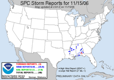
The above image is a map of storm reports from the Storms Prediction Center (www.spc.noaa.gov) as of Wednesday evening. the blue dots represent damaging wind reports and the red dots represent tornado reports.
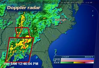
We could see more reports of severe weather late tonight through tomorrow as this storm system moves toward the Carolinas.
Here in central North Carolina, strong to severe thunderstorms are a possibility Thursday morning into the midday hours. It appears the greatest threat will come from 4am through 3pm. Damaging winds and even a few isolated tornadoes will be a threat in the strongest storms.
At this point, we cannot say for certain that severe weather will happen Thursday. However, it is a possibility and now is the time to make sure you are prepared in the event that severe weather sweeps through the region.
We'll be here in the Weather on the Ones forecast center with the latest updates through the morning. Be sure to tune in for up to the minute weather information. If you experience severe weather in your neighborhood Thursday, let us know by e-mailing weather@news14.com
Wednesday, November 08, 2006
Tuesday's Rain Totals
In Joshua's blog post yesterday, he asked if you were voting for sunshine. That may have been the only unanimous vote from Election Day! That sunshine is eventually on the way along with warmer temperatures for Thursday and Friday. Afternoon temperatures look to reach the upper 70s in some spots Friday!
The clouds are sticking around today though, and we stand the chance to see a few spotty showers this afternoon. However, we shouldn't see the widespread rain that we saw yesterday.
Here's a look at rain totals from Tuesday through early Wednesday morning --
The clouds are sticking around today though, and we stand the chance to see a few spotty showers this afternoon. However, we shouldn't see the widespread rain that we saw yesterday.
Here's a look at rain totals from Tuesday through early Wednesday morning --
- Raleigh-Durham: 2.44"
- Clayton: 2.39"
- Lumberton: 2.05"
- Chapel Hill: 2.00"
- Fayetteville: 1.99"
- Erwin: 1.55"
- Southern Pines: 1.40"
- Henderson-Oxford: 1.21"
- Rocky Mount-Wilson: 1.17"
- Reidsville: 1.08"
- Greensboro: 0.93"
- Goldsboro: 0.87"
- Burlington: 0.82"
- Winston-Salem: 0.70"
- Asheboro: 0.62"
- Lexington: 0.54"
Tuesday, November 07, 2006
Voting for More Sunshine?

This Election Day has been a total washout region wide as heavy rain is making for a dreary afternoon. A large upper level system is driving moisture from the Gulf of Mexico and Atlantic over North Carolina. Moisture in the form of clouds and rain will continue into tonight as rain totals exceed an inch in some spots.
Our parent website News14.com has an interesting story about weather and elections. It seems some believe overall turnout could reach low levels not seen since the 1920's in North Carolina! Also, if you're in the mood to cast a vote we've got a News 14 SnapPoll on the right hand column of the same page asking, "Which party will control Congress after tonight?" Be sure to add your thoughts on this hot topic.
I'll be hitting the voting booth tonight after work on the way home. I sure hope I'm able to get in and out quickly, but I won't be the least bit upset if I have to wait to cast my vote.
Looking ahead to tomorrow in the weather department you'll will find a better day, but a slight chance to see another round of showers and a possible storm. The same upper level system has some cooler air transfered higher in the atmosphere. As the sun breaks out Wednesday the ground will warm causing air to rise in this cooled air above. As this warmer air rises is won't be slowed by the cooler parcels, so clouds with rain and with an isolated storm is not out of the question.
Sunday, November 05, 2006
Record Cold Sunday
Temperatures dropped into the 20s across central North Carolina this Sunday morning, and that was cold enough to break the record low at the Raleigh-Durham Airport. The old record of 27 was set in 1995. This morning the low dropped to 25.
Here's a look at Sunday morning lows from around the region --
Here's a look at Sunday morning lows from around the region --
- Southern Pines: 21
- Burlington: 22
- Chapel Hill: 24
- Louisburg: 25
- Smithfield: 25
- Greensboro: 26
- Lumberton: 26
- Rocky Mount-Wilson: 27
- Asheboro: 27
- Erwin: 27
- Lexington: 27
- Mount Airy: 27
- Fayetteville: 28
- Goldsboro: 28
- Winston-Salem: 29
Although Monday morning will be cold, it won't be quite as cold as the last couple of mornings. Lows are forecast to drop to the mid 30s around daybreak. Some outlying area may reach the low 30s.
Milder weather is ahead for the new week. Afternoon highs should reach the 70s by midweek.
Saturday, November 04, 2006
Saturday Morning Lows
One word to describe the weather early this morning -- COLD! Many neighborhoods recorded the coldest temperatures so far this season. Here's a look at Saturday morning lows from around the region --
- Southern Pines: 23
- Burlington: 26
- Chapel Hill: 26
- Lumberton: 26
- Louisburg: 27
- Mount Airy: 27
- Rocky Mount-Wilson: 27
- Erwin: 28
- Greensboro: 28
- Raleigh-Durham: 28
- Smithfield: 28
- Winston-Salem: 28
- Asheboro: 30
- Goldsboro: 30
- Lexington: 30
- Fayetteville: 31
We're in store for another cold one tonight. By Sunday morning, we are likely to be back in the upper 20s to near 30.
Friday, November 03, 2006
Freeze Warning for Saturday Morning
Hope you were able to dig the heavy coat out of the closet this morning. If not, you'll want to find it as our chilly weather will continue through the weekend.
Here's a look at lows from Friday morning from around the region:
Here's a look at lows from Friday morning from around the region:
- Louisburg: 28
- Chapel Hill: 29
- Asheboro: 30
- Mount Airy: 30
- Raleigh-Durham: 32
- Rocky Mount-Wilson: 32
- Greensboro: 33
- Winston-Salem: 33
- Burlington: 34
- Goldsboro: 34
- Smithfield: 34
- Southern Pines: 34
- Fayetteville: 36
- Lexington: 37
- Lumberton: 37
Saturday morning's lows will likely be colder than Friday. We should all have temperatures below freezing for at least a few hours early Saturday morning. A Freeze Warning has been posted for much of the region.
Here's the official word from the National Weather Service --
1102 AM EST FRI NOV 3 2006
...FREEZE WARNING REMAINS IN EFFECT FROM MIDNIGHT TONIGHT TO 8 AM EST SATURDAY...
A WIDESPREAD HARD FREEZE IS EXPECTED ACROSS THE AREA. LOWS TONIGHT WILL DROP INTO THE MID AND UPPER 20S LATE TONIGHT THROUGH EARLY SATURDAY MORNING.
A FREEZE WARNING MEANS SUB-FREEZING TEMPERATURES ARE IMMINENT OR HIGHLY LIKELY. THESE CONDITIONS WILL KILL CROPS AND OTHER SENSITIVE VEGETATION.
Thursday, November 02, 2006
Tracking Cooler Temperatures
We all have enjoyed warm fall weather the last few days, but that warm weather is quickly coming to an end.
Yesterday many of us recorded highs well into the 70s --
Yesterday many of us recorded highs well into the 70s --
- Asheboro: 79
- Fayetteville: 79
- Henderson-Oxford: 79
- Lexington: 79
- Lumberton: 79
- Smithfield: 79
- Burlington: 77
- Erwin: 77
- Louisburg: 77
- Raleigh-Durham: 77
- Rocky Mount-Wilson: 77
- Southern Pines: 77
- Chapel Hill: 76
- Greensboro: 76
- Mount Airy: 75
- Winston-Salem: 75
Temperatures near 70 are likely again today in the Sandhills while the rest of us will see highs in the 70s.
From our forecast high temperature map, you'll notice the cooler temperatures to our north and west. That cooler air is settling into North Carolina and that will lead to a chilly Friday and a cool weekend. After a starting the morning in the 30s, highs tomorrow afternoon should not get any warmer than the low 50s. Then the really cold temperatures will come late Friday night and early Saturday morning as lows drop to the upper 20s.
Don't forget to bring those sensitive plants inside today and make sure your pets have a warm place to stay!
Wednesday, November 01, 2006
Is it really November?
With temperatures in the 70s this afternoon, it doesn't feel much like the first day of November. At 1pm today, it was 77 in Fayetteville, 74 in Raleigh, and 72 in Greensboro. Compare that to normal highs in the mid to upper 60s this time of year.
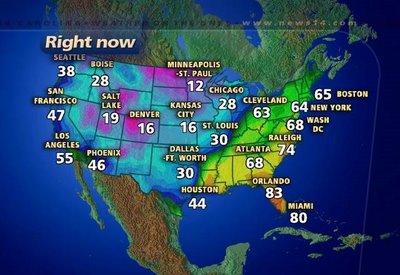
Of course the warmer than normal November weather can't last forever. We're already tracking cooler weather that is headed our way for the end of the work week and the weekend. Here's a look at forecast highs across the country this Wednesday:
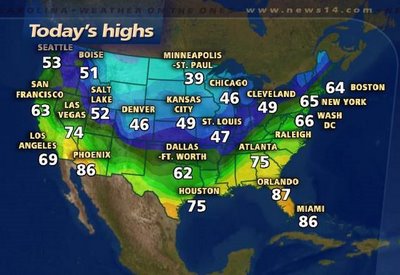 You'll notice highs in the upper 30s to 40s from Minneapolis to Chicago to Kansas City. That cold air will make a push toward the east coast as a cold front moves our way late tonight and tomorrow.
 Our highs by the end of the week won't be quite that cold, but we expect highs only in the mid 50s and lows in the 30s for Friday and Saturday.
By the way, that front that will move through the Carolinas late tonight and early tomorrow won't have much moisture to work with. That means we do not expect much in the way of rain from this system. We may just see a few sprinkles in the early morning hours Thursday.
Plenty of sunshine is the forecast through the weekend, just keep those cooler temperatures in mind.
Friday, October 27, 2006
Fall Back This Weekend

Everyone gets an extra hour to enjoy the weekend! We fall back to standard time this weekend, so don't forget to set your clocks back an hour before going to bed Saturday night. Standard time officially begins at 2am Sunday morning. Enjoy that extra hour of sleep!
Rainy Friday
It is a rainy end to this work week across North Carolina. This was the scene along the beltline in Raleigh around midday --
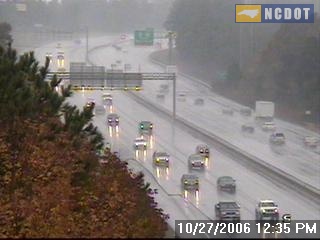
And this was the scene around the Triad about the same time --

And this was the scene around the Triad about the same time --

A well developed storm system, part of which produced blizzard conditions in Colorado, is making its move across the southeast. Doppler radar from midday showed widespread rain across the Carolinas, Georgia, and Alabama. 
This will keep rain around central North Carolina tonight. In fact, the rain may pick up through the evening as the area of low pressure tracks closer to the state.
 Most computer models agree that between one and two inches of rain are likely for our region from this storm. Some spots from the Triad to the west may see as much as three inches.
 You can see the latest radar images by tuning into Weather on the Ones every 10 minutes on News 14 Carolina.
While we are starting the weekend on the soggy side, most of the weekend should be pleasant. The rain will finally come to an end early Saturday morning. With clearing through the day Saturday, we'll see a lot of sun in the afternoon.
Thursday, October 26, 2006
Rainy Weather for Friday
We are watching a developing storm system over parts of the country this Thursday. That system will eventually lead to a very wet Friday afternoon and night in central North Carolina.
While we are enjoying cool temperatures and some sun today, part of that developing storm is producing heavy snow in Colorado where blizzard warnings are in effect for some locations.
Take a look at a traffic camera today from Denver...
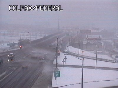 and another from Colorado Springs ...
While we are enjoying cool temperatures and some sun today, part of that developing storm is producing heavy snow in Colorado where blizzard warnings are in effect for some locations.
Take a look at a traffic camera today from Denver...
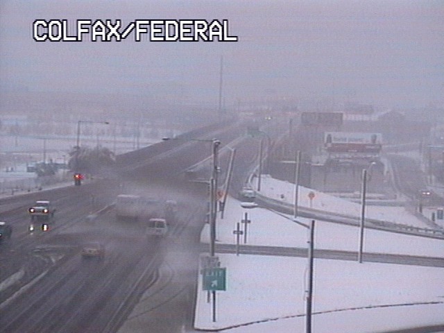 and another from Colorado Springs ...
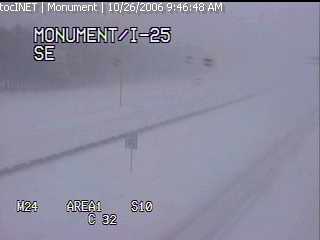 As of midday Thursday, the Denver airport had recorded about 4 inches of snow, but some spots in Colorado have reported well over a foot.
As the storm moves east late this afternoon, stormy weather is possible over the south central U.S. The Storms Prediction Center is watching an area from east Texas to Oklahoma to Louisiana for the possibility of severe storms today --
The storm system will continue to track to the east into the day Friday bringing us more clouds tonight and eventually a few showers in the morning. While we don't expect severe weather in our viewing area at this time, the rain could really pick up Friday afternoon and Friday night.
 How much rain could we pick up from this storm? Many of us will likely see between one and two inches of rain. However, some spots especially around the Triad may see closer to three inches!
 The bright spot in the forecast will come by midday Saturday through Sunday. The rain may continue into early Saturday morning, but it will move to our east bringing more sunshine our way by Saturday afternoon.
Wednesday, October 25, 2006
Another Cold Start
 No doubt, many heaters across central North Caroline have gotten their first work out of the season the past couple of mornings. Many locations got at least close to the freezing mark this morning. A few early morning clouds prevented some spots from getting all the way to freezing. Here's a look at lows from around the region this Wednesday:
 - Southern Pines: 28
- Lumberton: 30
- Chapel Hill: 31
- Asheboro: 32
- Burlington: 32
- Lexington: 32
- Smithfield: 32
- Greensboro: 33
- Raleigh-Durham: 33
- Mount Airy: 34
- Goldsboro: 34
- Fayetteville: 35
- Louisburg: 36
- Oxford-Henderson: 36
- Winston-Salem: 36
While we were certainly cold this morning, it wasn't record cold. The records for this date are 27 for Raleigh and 28 for Greensboro, both set in 1962.
One other cold weather fact to note -- the earliest snowfall for Raleigh occurred on yesterday's date in 1887, 1903, and 1910. A trace of snow was reported each of those years.
Snow is not in our forecast anytime soon. However, Friday will likely be a cool and rainy day for the region. Stay tuned to Weather on the Ones for the latest!
Monday, October 23, 2006
Brighter, but Cooler...
Our local weather has changed significantly the last 24 hours. The up's and down's of Autumn are in full swing in North Carolina. In fact, yesterday and today are a perfect example of the changing seasons.
High temperatures throughout the area were held in-check to the upper 50's to near 60 on Sunday. The clouds and rain put a lid on allowing the thermometer to move upward. Now, if we'd had full sunshine, afternoon readings would have been at least ten degrees warmer!
While Sunday's airmass was relatively warm and moist- Monday's airmass is much cooler and drier. More a reminder that winter is on the way as a sunny sky has allowed for a beautiful day, but once you make your way outside it feels much different. Afternoon Monday has regional temperatures ranging from the mid to upper 50's. That's with more sunshine! Now, expect tonight and tomorrow night to be pretty chilly as widespread lower 30's will be common to Central and Eastern North Carolina.
On a side note, I wanted to mention a trip this past weekend to Atlanta for a close friends wedding. I drove this time around instead of taking to the air and found the fall colors shaping up not only in North Carolina, but all the way down to North Georgia! Beautiful reds, oranges, and golds are slowly reaching their peak in many spots along I-85. Sometimes it takes a nice long drive to make you appreciate the season. Seeing the color change certainly made the drive different, but somewhat splendid.
Sunday, October 22, 2006
Dreary Sunday
 It was a dreary Sunday for the last day of the North Carolina State Fair, and it wasn't much different across most of central North Carolina. Light showers moved through during the day, but rain totals did not add up to much in most locations. The heaviest rains fell across the Sandhills.
Here's a look at rain totals from around the region:
- Fayetteville: 0.42"
- Goldsboro: 0.27"
- Lumberton: 0.19"
- Burlington: 0.17"
- Chapel Hill: 0.17"
- Oxford-Henderson: 0.17"
- Raleigh-Durham: 0.16"
- Greensboro: 0.12"
- Erwin: 0.11"
- Clayton: 0.10"
- Rocky Mount-Wilson: 0.05"
- Winston-Salem: 0.03"
The rain is moving out of the state this Sunday evening, we can look for clearing skies overnight. That will allow for a brighter start to the new week, but it will be cool for much of the week ahead. Highs will struggle to reach 60 on Monday, and we will likely stay in the mid 50s in most spots Tuesday.
The really cold temperatures will come during the early morning when lows will drop to the 30s for Tuesday and Wednesday morning. Patchy frost will be possible from the Triangle to the Triad both mornings.
Stay tuned to News 14 Carolina for your latest weather updates this week. We'll be along every 10 minutes with your Weather on the Ones forecast.
Saturday, October 21, 2006
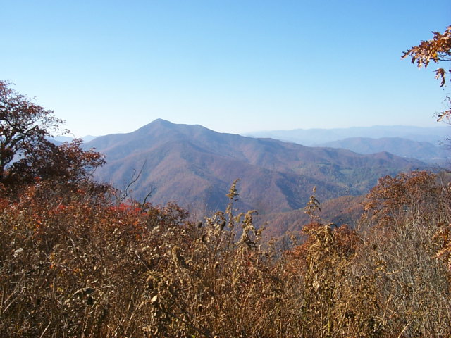
Fall Colors
Driving around central North Carolina, we're beginning to see more and more of those fall colors showing up. One of my favorite places to see the fall colors is the mountains of North Carolina. Here's a picture taken Saturday afternoon from a web cam looking toward Cold Mountain in the Pisgah National Forest --
 While there's nothing like seeing the splendid colors in person, if you're like me and can't make the trip to the mountains this year, you can see live views of the fall colors from your computer desktop. Check out www.highcountrywebcams.com for live views from around western North Carolina.
If you've visited the mountains this year and have some pictures of the fall foliage you'd like to share, e-mail them to us at weather@news14.com. We'll share some of them right here in our Weather on the Ones Blog.
For more pictures and information on the fall foliage around North Carolina, check out these links --
Friday, October 20, 2006
Last Weekend for the Fair
 Thousands and thousands of folks have visited west Raleigh for the North Carolina State Fair this year. If you haven't been one of the thousands, there's still time to ride the rides and check out some of those deep fried goodies like fried Coca-Cola. While I tried to stay away from the deep fried foods this year, I have to recommend one of my favorite fair treats and that's the ice cream from North Carolina State's food science club. Even though it will be somewhat cool especially during the evenings, it won't be too cold to try out this treat!
So whether you like the ice cream, the turkey legs, the rides, or the exhibits at the fair, most of this weekend will feature great weather for the fair. Friday night will bring jacket weather with temperatures dropping into the 50s in the evening. Overnight lows will drop to mid 40s for early Saturday morning. Saturday afternoon will bring perfect weather for the fair -- sunny with highs in the upper 60s. Unfortunately, Sunday may not bring great fair weather as showers return to the forecast.
If you're visiting the fair this weekend, be sure to stop by the Time Warner Cable and News 14 Carolina booth just outside Dorton Arena. Chief Meteorologist Gary Stephenson will be there from noon until 3pm on Saturday, and you'll have the chance to meet our new weekend morning anchor Cassie Safrit from 5 until 8pm Sunday.
Thursday, October 19, 2006
Saharan Dust Could Affect Hurricanes

Think about this... tiny dust particles could have an effect on monster hurricanes. That's the latest word from researchers with the National Oceanic and Atmospheric Administration. Saharan dust clouds may limit hurricane activity in the Atlantic. Read more about how Saharan dust may impact our hurricane season through this link --
http://www.noaanews.noaa.gov/stories2006/s2719.htm
Wednesday, October 18, 2006
State Fair Fun...
I've had a blast meeting all the News 14 Carolina viewers that stopped by to see The Weather on the Ones team at the Time Warner Cable tent near Dorton Arena. I'm encouraged to learn that you tune to our channel to stay up to date on our always changing North Carolina weather. It's also good to know you trust us during severe weather situations. We're on every ten minutes each and every day and when the weather gets nasty we're not afraid to take control of the situation and go 'wall to wall'.
Okay, I'll step off the soap box now and get back to the subject. I've managed to get to the fair three times this year and I have not been let down! Why I even had my first giant turkey leg Wednesday. That was a sight to see, let me tell you. Here I am, all 5' 6" of me, carrying a turkey leg the size of a baseball bat along the Midway. Where else can you do that?!
So far my most memorable moment came last Friday when Jess Torpey and I stopped by the Agriculture tent to see the Stanley Cup. I've been waiting paitently for months to see the pride and joy of the NHL and the 2006 Champion Carolina Hurricanes. This amazing piece of history is just as breath taking in person as it is to see on television during the playoffs. Seeing it made me realize Lord Stanley's Cup has been more places on Earth than I have, or will ever see for that matter. What a moment, and one I won't soon forget.


Soggy Tuesday
We're getting a chance to dry out today after Tuesday's steady rainfall. Many locations from the Triad to the Triangle measured between 1 and 2 inches of rain. Here's a look at rain totals from around the region --
- Chapel Hill: 1.67"
- Asheboro: 1.67"
- Goldsboro: 1.28"
- Lexington: 1.16"
- Greensboro: 1.11"
- Burlington: 1.10"
- Fayetteville: 1.06"
- Raleigh-Durham: 0.99"
- Winston-Salem: 0.98"
- Rocky Mount-Wilson: 0.90"
- Reidsville: 0.75"
- Southern Pines: 0.65"
- Lumberton: 0.19"
We'll see dry weather for the rest of this afternoon and for Thursday, but the rain may soon return. A cold front will cross the state Friday and that will likely bring a few showers and possibly a thunderstorm our way during the first half of the day Friday.
Tuesday, October 17, 2006
Carolina Quake...
Some residents near Winston-Salem had a small quake early this morning. The National Earthquake Information Center in Golden Colorado registered the shaker as a 2.6 on the Richter Scale. When compared to the 6.6 magnitue quake that jolted the big island of Hawaii over the weekend; this one was like a drop in the bucket. Most of the aftershocks in Hawaii have been larger than what rattled residents in Forsyth County.
If you are interested in seeing some info about this small quake feel free to check out the USGS site. A brief write up and more details can be found here.
If you are interested in seeing some info about this small quake feel free to check out the USGS site. A brief write up and more details can be found here.
Monday, October 16, 2006
A Look Back and Ahead
The opening weekend of the 2006 North Carolina State Fair was a major winner in the weather department as all the clouds and rain stayed away! I was out for the last public appearance of the Stanley Cup as were many Carolina Hurricane fans. We were not dissapointed as the cup was well worth the trip. However, I think many would argue that the food is the real reason for going to the State Fair. I mean where else can you tempt your taste buds with a fried oreo, fried twinkie, fried dough, fired coke, and fried whatever you can think of.
Away from the fun we did experience the coldest air of the season over the Carolinas. Sunday morning was a clear and crisp 33 at the RDU International Airport which broke a 27 year old record!
Right now skies are beginning to fill in with clouds and early Tuesday morning showers will breakout throughout the state and last pretty much all day long. This is all in concert with a milder air mass that's going to make for a nice Wednesday and Thursday, but to get there we have to experience some wet weather on Tuesday.
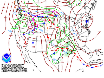
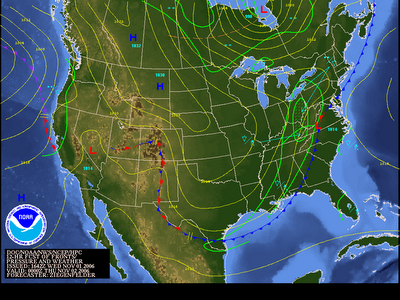
 Above is a weather map forecasting how this air mass will move within the next day and a half. Pay close attention to the red line with half-circles near the Gulf Coast. This is what is known as a warm front on all weather maps. This notation helps us determine where the warmer air is sitting. Keep in mind, the half-circles are in the direction that the warmer air is heading.
Along with a warm front comes the chance for some good soaking rains. This is certainly going to be the case with this system. By the time we see the sunshine on Wednesday rainfall totals could exceed an inch in many spots through Central and Eastern North Carolina and the Western part of our state may see closer to 2 inches of total rain.
Sunday, October 15, 2006
Hawaii Earthquake
 The big news from Sunday was a 6.6 magnitude earthquake reported just off the "Big Island" of Hawaii. Several aftershocks were felt after the initial quake. The above map from the U.S. Geological Survey shows the quakes measured Sunday around Hawaii.
Here are some links with more information on Sunday's quakes --
With news of the Hawaii earthquake, some may wonder about the possibility of an earthquake in North Carolina. While they are rare here, earthquakes can happen in our state. According to information from the USGS website, the strongest quake recorded in North Carolina took place near Waynesville on February 21, 1916. It was a magnitude 5.2 earthquake. There were reports of chimneys toppled and broken windows from the 1916 earthquake.
For more information on North Carolina earthquakes, check out these links --
Subscribe to:
Posts (Atom)