
A Winter Storm Warning is now in effect from 6am Thursday until midnight for the following counties in the News 14 Carolina viewing area: Granville, Vance, Warren, Forsyth, Guilford, Alamance, Orange, Durham, Davidson, Randolph, Chatham, Stanly, and Montgomery.
One to two inches of snow is possible Thursday morning in the warning area with an additional quarter of an inch of ice on top of the snow into the afternoon.
A Winter Weather Advisory is in effect from 6am Thursday until midnight for the following counties in the News 14 Carolina viewing area: Franklin, Wake, Moore, and Wilson. An inch of snow is possible Thursday morning with an additional ice accumulation less than a quarter of an inch.
For the latest updates, stay tuned to News 14 Carolina.
Wednesday, January 31, 2007
Wednesday Midday Update
It's the talk all around town today -- the chance for winter weather Thursday. It does appear that many of us will see winter weather tomorrow. This storm will likely have a bigger impact on our area compared to the winter weather a couple of weeks ago.
If you remember, a couple of weeks ago, we were just coming out of a weather pattern featuring warmer than normal temperatures. At the time, ground temperatures were in the mid 40s. Today ground temperatures are in the mid 30s. Any snow or sleet that falls will begin to stick to the ground fairly quickly.
Another factor about today's weather in North Carolina -- it's very dry. At midday Wednesday, dewpoints are in the single digits. With dry air in place, the precipitation that moves in Thursday will initially evaporate before hitting the ground. Evaporation cools the air and helps to lock in the cold air across the region when the precipitation eventually reaches the ground.
We've been closely watching the latest weather data pouring into the forecast office today. Here's our latest thinking on the winter weather threat --
- Precipitation should begin around 7-9am Thursday morning. From the Triangle to the Triad, the precipitation should start as all snow. In the Sandhills to Goldsboro, look for a mix of snow and sleet.
- Through the late morning hours, the snow will mix with sleet in the Triangle and the Triad.
- From the Sandhills to Goldsboro, the wintry mix should become all rain by midday.
- The snow and sleet mixture should become freezing rain in the Triangle and Triad around midday. The result could be 1-2" of snow with a quarter inch of ice on top of the snow.
- The winter mix should become all rain in the Triangle by mid to late afternoon. The changeover to rain may not take place in the Triad.
As with any winter storm in North Carolina, the forecast may change. We'll continue to follow the very latest in the forecast center. You can find the very latest on your forecast by tuning in for Weather on the Ones on News 14 Carolina.
When the winter weather begins in your neighborhood tomorrow, you can let us know what's happening in your community and send us digital photos to weather@news14.com
Have questions about the winter weather threat? Just click the comment link below.
Sunday, January 28, 2007
Sunday Evening Snow Flurries
We've had a few reports of snow flurries across the area Sunday evening as colder air is pushing into North Carolina. The precipitation will quickly exit the region late tonight. We do not expect any accumulation -- just a few flurries.
We've received reports of snow flurries from north Raleigh, Fuquay-Varina, Knightdale, McGees Crossroads, and Wilson. We also had one report of light sleet in west Raleigh. If you've seen winter weather, send us an e-mail at weather@news14.com.
Thanks to all our viewers who e-mailed and, as always, thanks for watching News 14 Carolina!
Cold Week Ahead
There will be no doubt about it when you step outside this week -- it is winter. A cold front pushing through North Carolina is ushering in the colder air Sunday evening. Temperatures will tumble to the mid 20s by Monday morning. It will be breezy at times and that wind will make morning temperatures feel more like the upper teens. Highs will only climb to near 40 Monday afternoon.
There's no significant warm up ahead for the next several days. Much of the week will bring highs in the 40s and lows in the 20s.
Some uncertainty remains in the forecast for the end of the week. At this point, it appears we could see our next round of precipitation for the Thursday-Friday timeframe. The question right now is just how much cold air will stick around for the end of the week. Yesterday's computer models suggested it would be warm enough for the precipitation to fall as all rain. Today's model runs hint at the possibility for some wintry precipitation. Tomorrow's models may say something different. As the end of the week approaches, we'll have a better idea on what to expect. For right now, we'll just say "a chance for precipitation" for Thursday.
We'll continue to monitor the latest weather data and update our forecast as needed. Stay tuned for Weather on the Ones...
Saturday, January 27, 2007
Warm Up Won't Last
What a beautiful day across the area this Saturday! After a chilly start this morning, it felt more like spring this afternoon. Temperatures soared into the 60s in many spots. Check out these afternoon highs from around the region --
- Fayetteville: 64
- Raleigh-Durham: 64
- Smithfield: 64
- Goldsboro: 63
- Louisburg: 63
- Lumberton: 63
- Southern Pines: 63
- Burlington: 62
- Chapel Hill: 62
- Asheboro: 61
- Erwin: 61
- Greensboro: 61
- Henderson-Oxford: 61
- Lexington: 61
- Rocky Mount-Wilson: 61
- Winston-Salem: 61
- Mount Airy: 57
Unfortunately, this warm up will not continue. Of course, that's good news if you like the cold weather because much colder temperatures are in store for early next week.
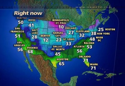
The above graphic shows temperatures across the country at 7pm Saturday evening. Notice the 10 degree reading in Minneapolis. Colder air is building in the north and will push toward North Carolina tomorrow and tomorrow night. While it will not get as cold as 10 degrees, some spots could drop to the upper teens to low 20s Monday and Tuesday mornings. Tuesday morning looks to be the coldest of the week ahead.
Looking for snow? There's no real signs that we'll see any over the next several days. A low pressure along the Gulf coast tonight will track toward the Carolina coast early Sunday morning. That will bring rain showers to eastern North Carolina but it will arrive before the cold air gets here. The front that will usher in the colder air will pass through the state tomorrow as well. That may wring out some left over moisture late Sunday afternoon and evening, but that would only produce a few snow flurries if anything at all. We'll watch for a few snowflakes late Sunday, but don't hold your breath.
Computer models continue to show a storm system tracking toward the state late in the week. It appears temperatures at that point will warm up somewhat, so any precipitation then would be in the form of rain. Of course, things can change between now and then. We'll continue to fine tune our forecast as needed. Stay tuned...
Friday, January 26, 2007
Cold Friday Morning
Brrrrr.... where are those 70s we had just a couple of weeks ago? Of course, it is January, so it is supposed to be cold, and it certainly was cold this morning. A few spots even dropped to the upper teens --
- Asheboro: 19
- Louisburg: 19
- Southern Pines: 19
- Burlington: 20
- Rocky Mount-Wilson: 20
- Lexington: 21
- Smithfield: 21
- Chapel Hill: 22
- Greensboro: 22
- Raleigh-Durham: 22
- Goldsboro: 23
- Henderson-Oxford: 23
- Winston-Salem: 24
- Fayetteville: 25
- Lumberton: 25
- Mount Airy: 25
By the way, while it was cold this morning, today was no where near the record lows for this date. On January 26, 2000, the low dropped to 13 in Raleigh-Durham. That was one day after a winter storm dumped over 20 inches of snow on the Triangle. That is the most snow on record from one storm in the Raleigh-Durham area. You can read more about that storm by clicking the following link:
http://www4.ncsu.edu/~nwsfo/storage/cases/20000125/
Speaking of winter weather, cold weather will return next week. We can look for highs in the 40s and lows in the 20s for much of next week. For you snow lovers, we don't look for any system that could produce precipitation for the region during the first half of the week.
However, there has been at least one computer model that has been somewhat consistent showing some precipitation for central and eastern North Carolina by the end of next week. It is much too early to speculate whether this could lead to wintry weather for us. We'll watch and see how things change over the next several days. Stay tuned....
Wednesday, January 24, 2007
New Storm Based Warnings
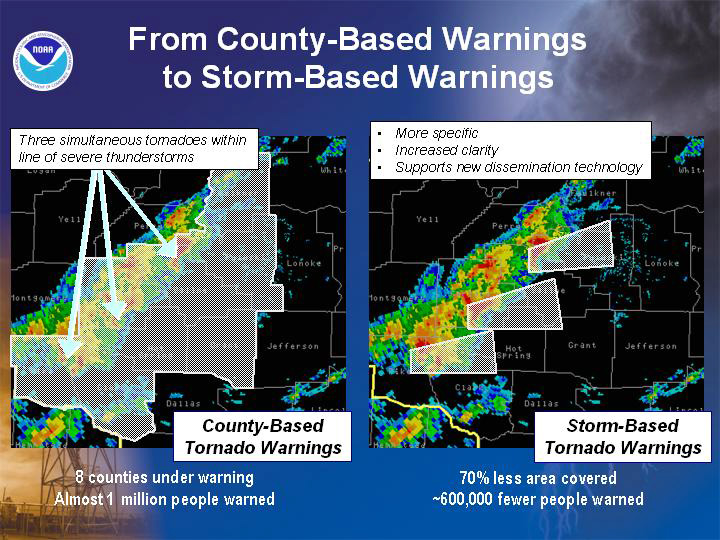 Starting this fall, the National Weather Service will change the way the organization issues severe weather warnings. Under the current system, warnings are issued for an entire county. The new warning system, the NWS will specify what areas in a county that could be affected by a severe storm. Local forecast offices have already been testing out the new warning methods over the last year.
You can read more about the new storm based warnings from this press release from the National Weather Service --
http://www.noaanews.noaa.gov/stories2007/s2776.htm
Sunday, January 21, 2007
Sunday Update -- 6:00pm
Here's a look at some reports from the last couple hours around the region --
-Viewer reports freezing rain in Henderson. Some ice collecting on cars.
-Viewer reports icicles forming on elevated surfaces in Wendell.
-National Weather Service reports some ice collecting on shrubs near their office on NC State's Centenniel Campus in Raleigh
-Viewer reports some ice collecting on shrubs in Youngvile
-Viewer reports icicles on powerlines near Mebane on the Orange/Alamance County line.
E-mail us reports from your neighborhood to weather@news14.com
Sunday Update -- 3:45pm
Just had a viewer e-mail report within the last 15 minutes of icicles forming in trees on the west side of Chapel Hill.
Let us know what's happening in your neighborhood and send us digital photos if you have them to weather@news14.com
Let us know what's happening in your neighborhood and send us digital photos if you have them to weather@news14.com
Sunday Update -- 3:10pm
The Winter Weather Advisory has been canceled for our area this evening. Most locations will just see a cold rain through the evening. There could still be some sleet mixed in with the rain and periods of freezing rain north and west of Raleigh toward the Triad. For these locations, only a light glazing of ice is expected on elevated surfaces. We'll keep you posted. Stay tuned for Weather on the Ones updates on News 14 Carolina.
Sunday Update -- 2:00pm
Light rain showers continue to fall across most of the area this afternoon. At times, some sleet could be mixed in with the rain. Temperatures are hanging near 32 right now from the Triad toward Chapel Hill.
If you're seeing sleet or freezing rain in your neighborhood today, you can let us know by e-mailing weather@news14.com
If you're seeing sleet or freezing rain in your neighborhood today, you can let us know by e-mailing weather@news14.com
Sunday Update -- 10:20am
Radar is showing some precipitation falling over central North Carolina this morning. Since the air is so dry across our area right now, most of that is not reaching the ground. However, around 10am this morning, we did receive several viewer e-mails of sleet in Durham.
Most of us will just see cloudy skies into the early afternoon hours. A few locations may see some sleet. More precipitation will move in later this afternoon. Most of that should be all rain from Raleigh to the south and east. North and west of Raleigh can look for a sleet/rain mixture. The Triad may see periods of freezing rain late this evening. Everyone should switch over to all rain by midnight.
For the areas that do see sleet or freezing rain, we only expect a light glazing on elevated surfaces.
Stay tuned to News 14 Carolina for Weather on the Ones updates through the day, and let us know the weather from your neighborhood by e-mailing us at weather@news14.com
Saturday, January 20, 2007
Cold Rain or a Wintry Mix?
Will it be just a cold rain or could we have another round of winter precipitation? That is the question we've been asking over the last couple of days when it comes to Sunday's forecast. Here in the Weather on the Ones Forecast Center, we've spent hours staring at computer screens, pouring over the latest weather data, and discussing the possibility of the winter weather. Most of the data points toward the idea that this will not be a big deal for the Triangle, and there could be a few spotty problems toward the Triad.
Cold and very dry air is settling in over North Carolina Saturday night. A storm system will begin to spread clouds our way toward the early morning hours on Sunday. As moisture streams our way, we'll eventually see precipitation begin to fall in the state. Initially, as the precipitation falls, it will evaporate because of the very dry air now in place over the region. The evaporation will cool the surrounding air dropping temperatures to the low to mid 30s as the precipitation moves in.
Much of our region will be on the borderline between just a cold rain and a wintry mix. For locations south of Raleigh, look for just a cold rain beginning Sunday evening. North and west of Raleigh, the rain could be mixed with sleet at times. In the Triad, we expect to see a rain/sleet mix along with periods of freezing rain.
At this point, we only look for a light glazing on elevated surfaces like powerlines, trees, and possible bridges in the locations that experience some sleet or freezing rain. There should not be enough accumulation to create any widespread problems.
We continue to follow the very latest data coming into the forecast center. We'll be here to provide you up to the minute information with Weather on the Ones.
When the precipitation begins to fall Sunday, you can let us know the weather from your neighborhood by e-mailing your weather report to weather@news14.com
Thursday, January 18, 2007
Snow Totals
Here's an updated look at snow totals from around central North Carolina from this Thursday morning:
Chatam County
Chatam County
- Siler City: 0.5"
Davidson County
- Lexington: 1.0-2.0"
Durham County
- Durham: 1.5"
Franklin County
- Pilot: 1.0"
Granville County:
- Creedmoor: 1.0"
- Butner: 0.5"
Guilford County
- Greensboro: 0.2"
Harnett County
- Lillington: 0.2"
Johnston County
- Clayton: 0.5"
Moore County
- Southern Pines: Trace
Randolph County
- Asheboro: 0.8"
Vance County
- Henderson: 0.2"
Wake County
- Morrisville (RDU): 1.0"
- Raleigh: 0.7"
- Cary: 0.8"
Warren County
- Warrenton: 0.2"
So, when's our next chance for winter weather? We may not have long to wait. There's a chance for more wintry precipitation Sunday, possibly as early as midday. A lot can change between now and then. A lot of details on this next system need to be ironed out. We're following the latest data that's coming into the forecast center, and we'll keep you updated as the weekend draws closer.
By the way, for a look at pictures submitted by our viewers today click to our News14.com Photo Gallery!
Thursday Update -- 12 Noon
Looks like this "winter weather event" is coming to an end across central North Carolina today. Light freezing rain is possible mainly north and west of Raleigh into the early afternoon, however any precipitation will be very light.
A few light rain showers are possible into the late afternoon, but most of the rain will be ending by sunset.
We've posted some select viewer photos in our blog. Unfortunately, we weren't able to post all of them here, but you can see all of them in our picture gallery link from our homepage at www.news14.com.
If you have winter weather photos to share with us today, continue sending them to weather@news14.com.
Thursday Update -- 10:35am
Latest snow totals from the National Weather Service --
Franklin County:
Franklin County:
- Pilot: 1.0"
Granville County:
- Creedmoor: 1.0"
- Butner: 0.5"
Harnett County:
- Lillington: 0.2"
Moore County:
- Southern Pines: Trace
Wake County:
- RDU Airport (Morrisville): 1.0"
- Cary: 0.5"
Warren County:
- Warrenton: 0.1"
Thursday Update -- 10:10am
 Another snowman picture. This one comes from Megan and Robert from Wendell.
We aren't able to upload all the pictures we receive to our weather blog, but you can see all the photos we have received in our photo gallery. Check it out on our homepage at www.news14.com
Some locations around the Triangle have seen as much as 1 to 2 inches on grassy surfaces. Let us know what's happening in your neighborhood. Send us an e-mail to weather@news14.com
Thursday Update -- 9:30am
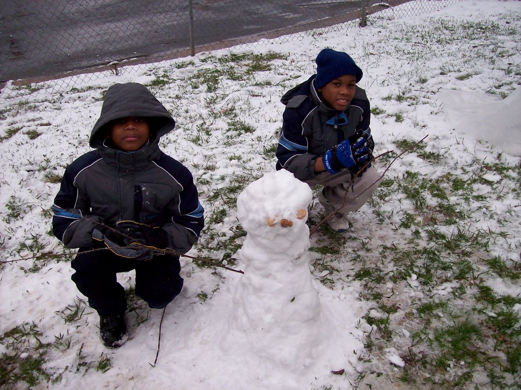
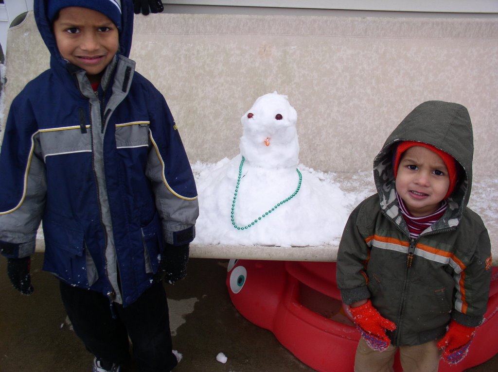
Some folks have gotten creative trying to make snowmen with the light accumulations we have seen today.
Here's one photo from the Stapelton family who recently moved to North Carolina from Florida.

Here's one photo from the Stapelton family who recently moved to North Carolina from Florida.
Thursday morning -- 9:10am
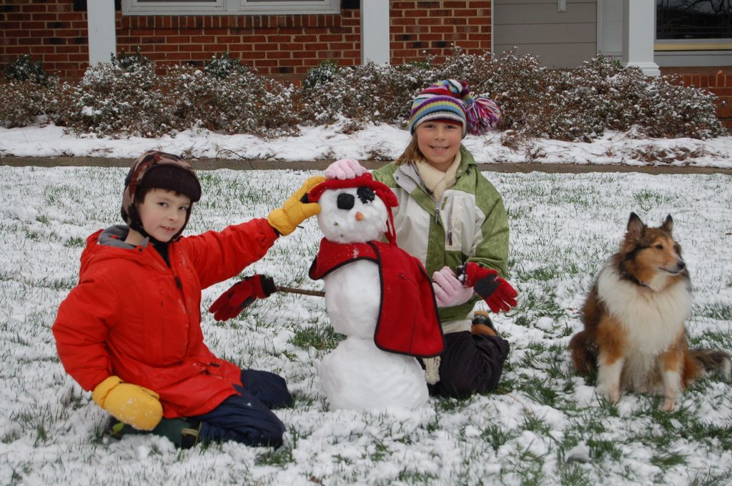 Photo of Christy and Ryan Johnson along with their dog Matt and their snowman Snowie. Photo from Raleigh
Thursday morning -- 8:05am update
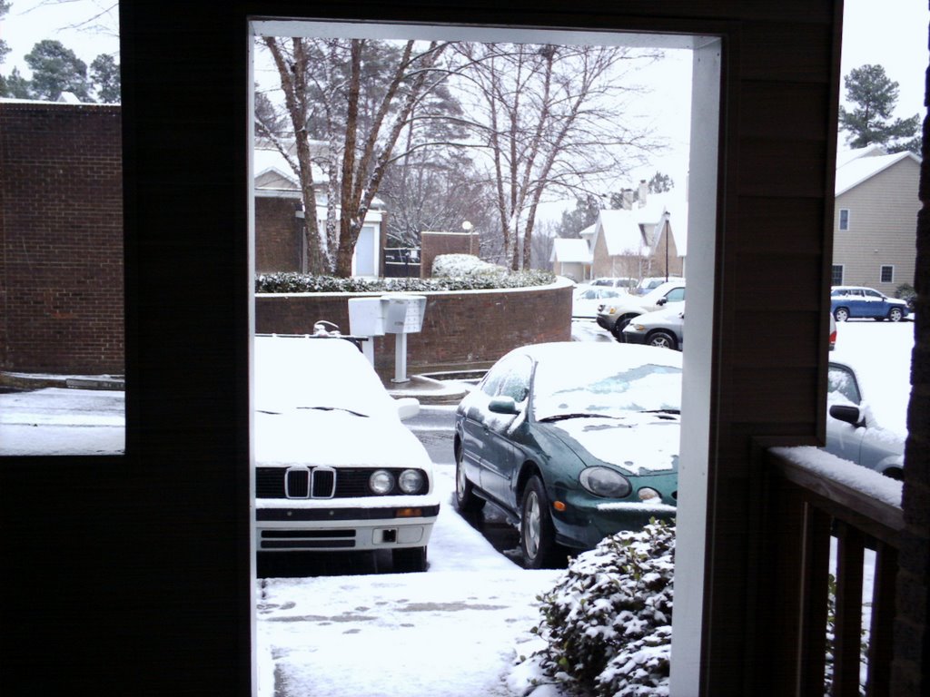 Photo from Marc off Sandy Forks Road in north Raleigh.
 Photo from Bakul is Morrisville.
 Photo from Mark in Knightdale.
Thursday morning -- 7:55am update

 Above two photos taken near Leesville Road in Raleigh.
 Above photo from Jason in Cary
Thursday morning -- 7:40am update

 Above photos from Emma in Apex. Emma tells us she just moved to Apex from Florida and is excited to see today's snow.
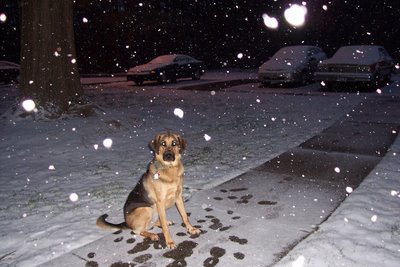
Alexis from Raleigh e-mailed us this photo taken in the North Hills area of town. She says that she and her dog Asia feel like they are home in Alaska.
Thursday Morning -- 7:30am update
Official reports of accumulation from the National Weather Service --
Clayton -- Trace of sleet on sidewalks
Lee County -- Light accumulation on bridges
Raleigh -- 0.3" measured at RDU
These are in addition to the numerous e-mails we have received of light accumulations around the Triangle. Send reports from your neighborhood to weather@news14.com
Clayton -- Trace of sleet on sidewalks
Lee County -- Light accumulation on bridges
Raleigh -- 0.3" measured at RDU
These are in addition to the numerous e-mails we have received of light accumulations around the Triangle. Send reports from your neighborhood to weather@news14.com
Thursday Morning 7:20am update
Numerous reports of light snow accumulations from around the Triangle are coming in this Thursday morning. There have also been reports of freezing rain across the Sandhills.
Send reports from your neighborhood and your weather pictures to weather@news14.com.
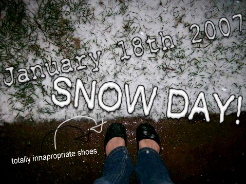
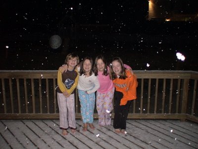 Viewer photo of Luke O'Dell, Kayla Dadisman, Hannah Dadisman, and Brenna O'Dell enjoying the snow this morning in Fuquay-Varina.
Send reports from your neighborhood and your weather pictures to weather@news14.com.
Viewer photo of Luke O'Dell, Kayla Dadisman, Hannah Dadisman, and Brenna O'Dell enjoying the snow this morning in Fuquay-Varina.
Wednesday, January 17, 2007
Wintry Mix for Thursday Morning
It has been a while since we've heard those words in the forecast for central North Carolina -- "wintry mix." Those two words are in the forecast for Thursday morning though. It's kind of hard to believe too when you consider many locations saw temperatures in the 70s this weekend and Monday. However, the cold air has arrived with temperatures struggling to reach the 40s today.
The other ingredient we need for winter precipitation is, of course, moisture. That ingredient will be supplied by a disturbance expected to develop late tonight off our coast. That will spread precipitation into North Carolina just before daybreak Thursday morning. With temperatures in the upper 20s to near 30, that precipitation will start as a mix of freezing rain, sleet, and some snow.
In the Sandhills around Fayetteville, the wintry mix should quickly change to all rain by mid-morning. As we move to the east toward Goldsboro, this will be mostly a rain event.
It will take a little longer to see the change over to rain in the Triangle. Around Raleigh-Durham, the mix should change to all rain around midday or the early afternoon. Ground temperatures are warm in the region thanks to the warm winter we have experienced so far. Because of that and the light precipitation in the forecast, we do not expect any significant accumulation. We'll have to watch elevated surfaces such as bridges and overpasses for a few slick spots. For the most part, this should be a minor event for the Triangle.
In the Triad, around Greensboro and Winston-Salem, the wintry mix will likely last a little longer as temperatures may not warm above freezing until the early afternoon. Again, the ground temperatures are relatively warm here too, but we may see some small accumulations on grassy surfaces and those bridges and overpasses.
With all of that said, if you've lived in North Carolina for a few winters, you know winter weather forecasting is tricky around here. We're watching the latest data and we'll fine tune our forecast as needed. Remember you don't have to wait until 6pm or 11pm for your forecast. We'll have the latest for you every 10 minutes on News 14 Carolina.
All of the precipitation should be out of the state by Thursday evening. The cool weather will remain through the weekend, but our weather could become "interesting" again late Sunday into Monday. Stay tuned...
Sunday, January 14, 2007
Record Set in the Triad
The old record high temperature was broken Sunday at the Piedmont Triad Airport in Greensboro. Sunday's high reached 71 around 3:16pm. The old record was 68 set in 1995.
The Triangle came close to breaking a record but didn't quite make it there Sunday afternoon. The high at RDU reached 74. The record for January 14 stands at 75 set in 1995.
Elsewhere in North Carolina records were broken New Bern where the high reached 74 and in Asheville where the afternoon temperature topped out at 66.
Saturday, January 13, 2007
Near Record Warmth?
Once again, it feels more like a spring weekend in North Carolina than the middle of January. Some locations in the state could come close to the record high for the next couple of days. Here are some temperatures to watch Sunday and Monday --
Raleigh record highs --
Raleigh record highs --
- Sunday, January 14 -- 75 (1995)
- Monday, January 15 -- 74 (1960)
Greensboro record highs --
- Sunday, January 14 -- 68 (1995)
- Monday, January 15 -- 73 (1960)
And while we are enjoying this spring like weekend, it certainly feels much more like winter in other parts of the country. A significant winter storm continues from Texas to Oklahoma through Missouri and all the way to Illinois.
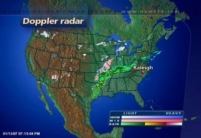
Another wave of moisture will move into the south central U.S. Sunday and Monday bringing more ice to Texas and Oklahoma. Locations as far south as San Antonio, Texas could deal with freezing rain and sleet by Monday. Winter weather will also spread toward Chicago and toward New England. Travel trouble spots Sunday and Monday will likely include Dallas/Fort Worth, Oklahoma City, Tulsa, Saint Louis, Chicago, and Boston.
This same storm is also spreading heavy rains from East Texas through the Ohio Valley. The rain will be slow to move toward North Carolina. By the time it gets here late Monday night and Tuesday, most spots will see just see scattered light showers possibly resulting in less than a tenth of an inch.
Look for more January like temperatures here in North Carolina Tuesday afternoon and Wednesday.
Thursday, January 11, 2007
Current Cold Snap Won't Last Long
Frigid temperatures across North Carolina had many of saying "brrrrr..." this morning. It certainly felt more like winter than it has in the past several weeks. Most locations dropped to the mid 20s early Thursday morning, but there were a couple spots that made it all the way to the upper teens --
- Louisburg: 19
- Southern Pines: 19
- Asheboro: 21
- Chapel Hill: 23
- Goldsboro: 23
- Lexington: 23
- Mount Airy: 23
- Rocky Mount-Wilson: 23
- Smithfield: 23
- Greensboro: 24
- Raleigh-Durham: 24
- Winston-Salem: 24
- Erwin: 25
- Fayetteville: 25
- Lumberton: 26
- Henderson-Oxford: 28
It will be a few days before the 20s return for morning lows though. A warming trend begins Friday. By the weekend, afternoon highs could climb as high as near 70 in some spots.
The weekend warming trend also won't last long. Arctic air is moving into parts of the western United States, and some of that cold air will eventually push toward the east coast. That will bring more winter like temperatures to our region by the middle of next week. No wintry weather in the forecast for now though...
Monday, January 08, 2007
Two Posts in One Day!
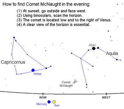
It's certainly not like winning the lottery, but when you can get two posts in one day from me... It's like having a comet viewable to the naked eye. It doesn't happen very often. Well, guess what? That's exactly why I'm writing. The comet McNaught (C/2006 P1) is so bright in the evening sky that it can be seen shortly after sunset.
Here's a map of the evening sky and where you'll need to look to see this spectacular comet.
Here's a map of the evening sky and where you'll need to look to see this spectacular comet.
Want to know what you're in for, here are some images taken from spaceweather.com. It shows a very mature comet with a long tail in the evening sky.


If you'd like to see more pictures or find out more about viewing, not only in the evening sky, but in the early morning as well visit spaceweather.com. There will be a ton of information to help you spot this great comet in the heavens.
Turning Cooler This Week...
Skies are in the process of clearing out in Central and Eastern North Carolina as drier weather will rule the roost most of this workweek. That wasn't the case the first week of 2007 as Mother Nature picked up right where 2006 left off- rainfall totals in many locations are once again surging above average.
- Raleigh: 1.65"
- Fayetteville: 0.88"
- Greensboro: 1.64"
- Charlotte: 2.15"
- Asheville: 2.82"
As the clouds break apart and move away from the Carolinas we can look forward to colder air making a comeback beginning tonight. A digging trough in the Eastern U.S. will allow for cold weather fans to unite in celebration.

Here's a look at one computer model clearly showing cold air dipping far along the East Coast. This is the first time in a few weeks where colder air has broken the strangle hold warm temperatures have had on the Eastern United States. This week we'll have overnight lows on Wednesday and Thursday in the 20s!
This is encouraging to see as I have quite a collection of winter clothes in my closet collecting dust. Honestly, we need cold air mixing from the poles to attempt to reach a balance in the atmosphere. If it stayed warm for the rest of winter, artic air would build up in Alaska and Canada- freezing our friends up north. ***I'm confident though that this building cold air would find a way to balance out. Nature hates to remain imbalanced for too long.*** Back on topic, it's common this time of year to have warmer air moving from the equator and colder air sliding down from the poles. We're just used to being on the receiving end of the colder air more often than the warmer. This mixing is also what makes spring and fall so active as we see large swings in warm temps versus cold temps from time to time- and an increase in severe weather.
Speaking of Alaskan temperatures there are signs the weather is getting very cold up north. I see a lot of negative numbers as Arctic air is growing colder. There are signs that a piece of this air mass is ready to move south. I'd say once we get to the middle of the month we'll be talking about much colder weather for the Northern U.S. It's still yet to be seen if this same cold air pocket will make it this far Southeast. As we get farther into January and February the sun angle is on the rise in the Northern Hemisphere and the sunshine will be able to moderate the air mass more efficiently than in late December and early January.
Saturday, January 06, 2007
Friday's Stormy Weather in the Carolinas
 Severe weather was reported is some spots around the Carolinas Friday afternoon and evening including tornadoes. One of those tornadoes touched down in Gaston County, North Carolina. That tornado was a short lived and relatively weak tornado rated an F0 on the Fujita scale.
Other tornadoes were reported in Pickens County, South Carolina and Spartanburg County, South Carolina. The Pickens County tornado touched down near the town of Liberty. That tornado was responsible for flipping several cars in an elementary school parking lot. Fifteen injuries were reported.
The Greenville-Spartanburg National Weather Service has more information on the severe weather in the Carolinas Friday night. Check on their detailed report at this link --
You can also read more on the Gaston County storm from news14.com --
No severe weather was reported in the Triangle and Triad. However, between a half and one inch of rain was reported in some spots. Here's a look at rain totals from Friday and early Saturday around our region:
- Chapel Hill: 1.15"
- Raleigh-Durham: 0.99"
- Fayetteville: 0.77"
- Southern Pines: 0.72"
- Burlington: 0.64"
- Goldsboro: 0.51"
- Greensboro: 0.50"
- Lumberton: 0.47"
- Rocky Mount-Wilson: 0.38"
- Henderson-Oxford: 0.35"
- Winston-Salem: 0.33"
Saturday shaped up to be a spring-like day here in early January with highs near 70 in many spots. The weather will change for Sunday though. While we expect another mild day, rain will return by the afternoon and evening hours.
In fact, a few strong storms could be a possibility in eastern North Carolina. The Storm Prediction Center as that part of our state under a "slight risk" for severe weather. We'll keep a close eye on radar through the day and keep you updated to any threat for strong storms. Just stay tuned for Weather on the Ones on News 14 Carolina!
Friday, January 05, 2007
Two Rounds of Rain This Weekend; Thunderstorms Possible
It's not too often that you hear us talk about thunderstorms in January in North Carolina, but a few thunderstorms are possible this Friday evening and another round of rain possibly with a few thunderstorms is expected late Sunday.
Let's start with the first round of rain. A few spotty showers are around the region this Friday afternoon, but we're watching an area of more widespread rain and thunderstorms that is moving our way for this evening.
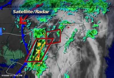
Let's start with the first round of rain. A few spotty showers are around the region this Friday afternoon, but we're watching an area of more widespread rain and thunderstorms that is moving our way for this evening.
Strong thunderstorms moved through the Atlanta area just before midday Friday. There were tornado warnings in effect around Atlanta during the late morning, but there have been no comfirmed reports of a tornado touch down at this point. There have been some reports of wind damage.
That same batch of rain and storms will move into North Carolina later today and could approach the Triad, Triangle, and Sandhills by around 8pm. We'll be watching radar closely to see if these storms hold their strength.
The Storms Prediction Center has placed eastern North Carolina under a "slight risk" for severe weather Friday evening because a few of the storms could prodcue gusty winds. We'll keep you updated to any watches or warnings that may be issued. Just stay tuned to News 14 Carolina.
This first round of rain should exit our area by early Saturday. That will give way to a beautiful day. How does partly cloudy skies and highs in the low 70s sound for the first weekend in January?
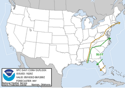
The break from the rain chances won't last too long. During the weekend, an area of low pressure will form along the Gulf coast and track our way. That brings rain back to the forecast Sunday afternoon, and again a few thunderstorms could be possible. In fact, as of Friday, the Storms Prediction Center has eastern North Carolina under a "slight risk" for severe weather Sunday --
There are still a couple of days to fine tune the chances for thunderstorms for late in the weekend. For the latest outlook for the weekend, tune in to News 14 Carolina on the ones.
By the way, you may have heard the old weather saying about lightning in the winter means snow is only 10 days away. Of course, that's just an old saying with no scientific backing. We'll see what the next week and half as in store for us, but there certainly is no snow in the forecast over the next 5 to 7 days.
Have a great weekend!
Wednesday, January 03, 2007
5 Years Ago = Snow
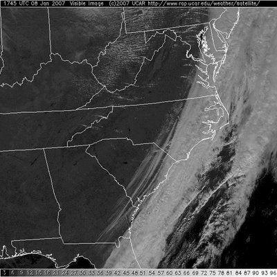
January 3, 2002 -- a significant snow storm was wrapping up across North Carolina.
 Visible satellite image from January 3, 2002. The white is not clouds, but snow blanketing much of the Carolinas.
Visible satellite image from January 3, 2002. The white is not clouds, but snow blanketing much of the Carolinas. 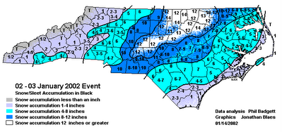
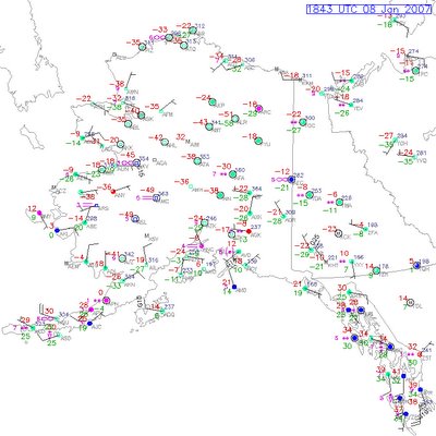
State snowfall totals from January 2-3, 2002 snowstorm.
The Triangle woke up to as much as a foot of snow just five years ago. The Triad had 8-10" and 4-8" blanketed the Sandhills.
Fast forward five years to January 3, 2007 and it's a much different story! No snow anywhere near North Carolina. It's much too warm for that. Highs today are in the low 60s, and the upper 60s are likely by the end of the week. Some spots may even see highs near 70 by Friday and Saturday.
Above normal high temperatures should continue into early next week. Normal highs this time of year are in the upper 40s in the Triad to near 50 in the Triangle.
While there is no snow in the forecast, we could see rain showers late in the work week and again for late in the weekend and early next week.
Snow lovers, don't give up just yet. It's only January and there's plenty of winter left on the calendar. For those of us that enjoy the mild weather, there's good news today. Check out this headline from news 14.com --
Subscribe to:
Posts (Atom)