
Computer models appear to be in better agreement this morning that low pressure will track up the Carolina coast during the early to middle part of next week bringing snow and rain to North Carolina. Some areas will see just rain, others will see all snow, and other may see a mix of snow to rain to snow.
Since we are still several days away, it is still much too early to make a call on what locations in the state could see significant snow and what areas would see just a cold rain. Based on the latest model data this morning, the Triangle would fall very close to the rain/snow line with significant snows possible to the west especially in the foothills and mountains. However, that all depends on the exact track of the low pressure. If the track changes more to the east, more significant snow would be possible toward the Triangle and even the Sandhills. At the same time, a more inland or westerly track would mean just rain for those areas. It appears the coast would mainly see just rain.
I caution that all of this is subject to change. Nailing down the exact track of low pressure that hasn't even developed yet is pretty much impossible at this point. We are still several days away and the models don't fully have a handle on how this storm system will evolve. Keep an eye on the forecast especially for Tuesday, Tuesday night, and Wednesday.
On another note, before we get to next week, low pressure will develop off the southeast coast Saturday. It should stay far enough offshore that any precipitation with that low will be out to sea. There is just a slight chance that the southern Outer Banks and Crystal Coast could see a few flurries or light snow showers Saturday evening.
Stay tuned to News 14 Carolina for the latest forecast!
Lee Ringer
News 14 Carolina Meteorologist
www.facebook.com/LeeRingerNews14
www.twitter.com/LeeRingerNews14
Friday, January 21, 2011


Thursday, January 20, 2011
Is More Winter Weather on the Way?
It has been quite the winter so far in the Carolinas, and we're only about half way through the season! After a brief warm up during the middle of this week, colder temperatures will return for the weekend, and the chance for winter precipitation could return by early next week.
Before we get to next week though, we'll have to keep an eye on low pressure that will develop off the southeast coast Saturday. This low should stay far enough offshore to keep most precipitation offshore. However, it is possible that the low tracks a little closer to the coast spreading snow flurries or light snow showers across coastal areas late Saturday afternoon or Saturday evening. The Triangle and Sandhills will stay dry with no precipitation over the weekend.
Then our attention turns to Monday into Tuesday of next week. Cold air will be in place over central North Carolina as low pressure tracks from near the Gulf coast to off the Carolina coast. Since this is still several days away, details with this system are still very uncertain and computer models are not in full agreement with exactly how this weather system will set up. It does appear precipitation will start by late Monday across the Sandhills and Triangle as some type of winter precipitation - either snow or a wintry mix. The precipitation may change to a cold rain into Tuesday in the Sandhills. The Triangle may be right on the dividing line between an area that sees mainly winter precipitation and an area that changes to a cold rain. At this time, it appears coastal areas would mainly just see rain showers. Precipitation amounts are uncertain at this point, so it's too early to say if this will just be a nuisance event or a more significant event.
As with the past winter systems this season, details in the forecast should become clearer over the coming days. Stay tuned for our Weather on the Ones updates for the latest!
Lee Ringer
News 14 Carolina Meteorologist
www.facebook.com/LeeRingerNews14
www.twitter.com/LeeRingerNews14
Before we get to next week though, we'll have to keep an eye on low pressure that will develop off the southeast coast Saturday. This low should stay far enough offshore to keep most precipitation offshore. However, it is possible that the low tracks a little closer to the coast spreading snow flurries or light snow showers across coastal areas late Saturday afternoon or Saturday evening. The Triangle and Sandhills will stay dry with no precipitation over the weekend.
Then our attention turns to Monday into Tuesday of next week. Cold air will be in place over central North Carolina as low pressure tracks from near the Gulf coast to off the Carolina coast. Since this is still several days away, details with this system are still very uncertain and computer models are not in full agreement with exactly how this weather system will set up. It does appear precipitation will start by late Monday across the Sandhills and Triangle as some type of winter precipitation - either snow or a wintry mix. The precipitation may change to a cold rain into Tuesday in the Sandhills. The Triangle may be right on the dividing line between an area that sees mainly winter precipitation and an area that changes to a cold rain. At this time, it appears coastal areas would mainly just see rain showers. Precipitation amounts are uncertain at this point, so it's too early to say if this will just be a nuisance event or a more significant event.
As with the past winter systems this season, details in the forecast should become clearer over the coming days. Stay tuned for our Weather on the Ones updates for the latest!
Lee Ringer
News 14 Carolina Meteorologist
www.facebook.com/LeeRingerNews14
www.twitter.com/LeeRingerNews14
Wednesday, January 12, 2011
January 10-11, 2011 Snowfall
 Snowfall totals from Monday-Tuesday, January 10-11, 2010:
- Hampstead: 7.0"
- Laurinburg: 7.0"
- Rocky Point: 6.0"
- Whiteville: 5.5"
- Lumberton: 5.0"
- Fayetteville: 5.0"
- Raeford: 5.0"
- Southern Pines: 5.0"
- Elizabethtown: 5.0"
- Burgaw: 4.0"
- Kenansville: 4.0"
- Havelock: 4.0"
- Topsail Beach: 4.0"
- Wilmington: 3.8"
- Vander: 3.5"
- Morehead City: 3.0"
- Anderson Creek: 2.2"
- Atlantic Beach: 1.5"
- New Bern: 1.5"
- Hillsborough: 1.1"
- Louisburg: 1.0"
- Mount Olive: 1.0"
- Newton Grove: 1.0"
- Roxboro: 1.0"
- Sanford: 1.0"
- Siler City: 1.0"
- Wrightsville Beach: 1.0"
- Creedmoor: 0.5"
- Durham: 0.5"
- Burlington: 0.5"
- Chapel Hill: 0.2"
- Raleigh: 0.2"
- Wilson: Trace
Ice Accumulation from January 10-11, 2010:
- Holly Springs: 0.2"
- Laurinburg: 0.2"
- Fayetteville: 0.2"
- Raeford: 0.2"
- Louisburg: 0.15"
- Southern Pines: 0.15"
- Oxford: 0.1"
- Raleigh: 0.1"
- Wilson: 0.1"
- Goldsboro: 0.05"
Sunday, January 09, 2011
Tracking Winter Weather -- Sunday Morning Update
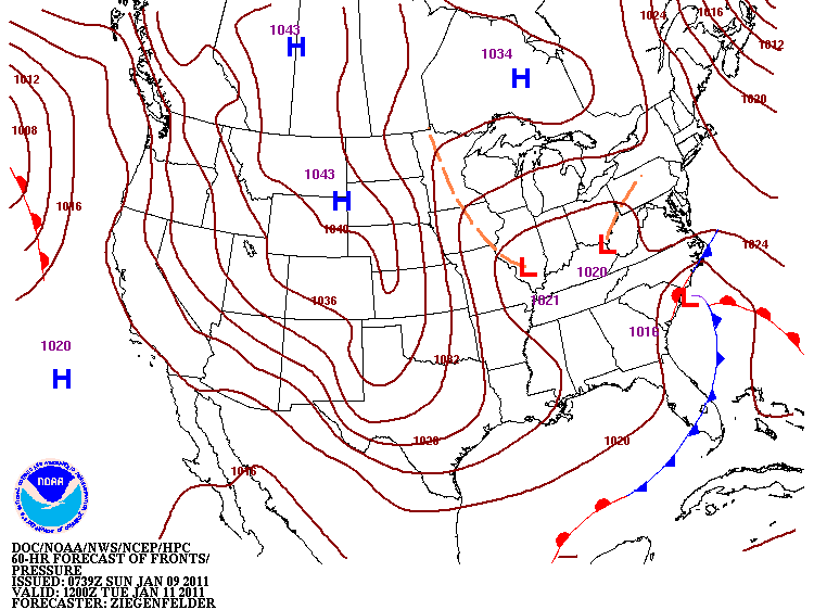
A storm system will track across the southeast into the new week spreading snow and ice across parts of the southeast including North Carolina. The details of the storm are becoming more clear for North Carolina, and it does not appear this will be a repeat of the post-Christmas snow. While some snow is possible with this storm, sleet and freezing rain could be the bigger issue for our region. Light snow is expected to spread into parts of the state near Charlotte and the NC/SC border around daybreak Monday. Because of dry air across much of central North Carolina, it will take a while for the precipitation to track north. Light snow will eventually spread from the southwest to northeast through Monday afternoon. By Monday evening, that precipitation will change to more of a wintry mix.
Based on the latest weather data, here's my thinking of what different regions of our coverage area can expect:
Triangle
Light snow will spread across the Triangle Monday afternoon or evening before changing to sleet then freezing rain or freezing drizzle Monday night. Precipitation will taper off Tuesday morning to around midday Tuesday. Around 1-2" of snow is possible before the change over to an icy mix. These accumulations will be slightly higher southwest of Raleigh and lower northeast of Raleigh. The snow accumulation will depend on the start time of the precipitation in the area. A later start time would mean less snow and an earlier start time would mean more snow accumulation. On top of any snow accumulation, 0.1" to 0.25" of ice accumulation is possible. This will create dangerous travel conditions Monday night and Tuesday morning. If ice accumulation reaches 0.25" or higher, look for power outages.
Sandhills
Light snow will spread across the Sandhills Monday morning and will then change to an icy mix by late Monday afternoon or evening. Snow accumulations of 1-4" is possible with the higher totals west of Fayetteville. Ice accumulation up to 0.25" is possible. Look for dangerous travel conditions developing Monday afternoon and continuing through Tuesday. If ice accumulation reaches 0.25" or higher, power outages will become a problem.
Wilson/Goldsboro
Some light snow is possible by late Monday afternoon or evening. Snow accumulation of a trace to an inch is possible. Any light snow will change to sleet and then freezing rain Monday evening and Monday night before ending Tuesday morning to around midday Tuesday. Ice accumulation of 0.1" to 0.25" is possible. Look for dangerous travel conditions Monday night and Tuesday morning.
Coastal viewing area
Light snow or a wintry mix will spread toward the southeast coast by late morning to early afternoon Monday. The precipitation will slowly build to the north through the afternoon and evening. A changeover to rain is expected by Monday evening. Most locations along the immediate coast will likely not see any accumulation as those locations will likely see mainly a cold rain. Areas inland from the coast across Columbus, Bladen, and Duplin County could see a dusting to 1" of snow/sleet accumulation with a light glazing of ice before changing to rain Monday night.
Keep in mind a change in track or intensity of this storm system could change the weather expected in your area. Winter weather forecasting is difficult in North Carolina, and changes in the forecast are still possible. Stay tuned to News 14 Carolina for the latest Weather on the Ones updates.
Lee Ringer
News 14 Carolina Meteorologist
www.twitter.com/LeeRingerNews14
www.facebook.com/LeeRingerNews14
Friday, January 07, 2011
Snow for Friday Night, More Snow and Ice for Early Next Week

Lots of winter weather to talk about today! I'll start with a disturbance that will produce a band of snow across central North Carolina tonight. This disturbance will create heavier accumulations in the mountains, but a band of a dusting to 2" is possible across the Piedmont to northeastern North Carolina. This includes areas around the Triangle.
Tonight's snow could begin as early as late afternoon. If that happens, the precipitation would start as light rain then mix with and change to snow. Accumulations would likely be mainly on grassy surfaces but some slush may build up on roads. Locations south of the Triangle near Fayetteville can look for mainly a light rain possibly mixed with some snow as the precipitation ends. Little to no accumulation is expected in the Fayetteville area. Most of the precipitation should taper off around midnight give or take an hour or two.
Temperatures will hover in the mid 30s as the precipitation falls and then fall below freezing as the precipitation ends. Lows in the upper 20s to near 30 are expected by daybreak Saturday morning in the Triangle and Sandhills. This could create issues with black ice Saturday morning even in areas that see mainly a light rain.
For our coastal viewers, tonight's band of precipitation will mainly miss our area to the north and northwest. A few light sprinkles cannot be ruled out late tonight.
This weekend our attention then turns to the potential for a more significant winter weather system for Monday through Tuesday of next week....

 Low pressure along the Gulf coast Sunday night and Monday morning will track to off the North Carolina coast by Tuesday morning. Cold air will be in place across North Carolina as precipitation spreads across the state Monday afternoon. This looks to begin as snow in the Triangle and Sandhills, but I am growing more concerned that the snow will change to sleet and freezing rain Monday night or early Tuesday morning. If that happens, it appears there would be enough icing for significant travel problems and power outages. Keep in mind that is just one scenario with this system at this point.
The forecast remains even more uncertain for early next week in coastal North Carolina. Precipitation looks certain with some rain, but that rain may change to a wintry mix for a period of time.
Since we are still a few days away, a lot could still change with the forecast for next week. It is still too early to speculate on too many specifics about this storm. Through the weekend, we should have a better idea on how all of this will come together. Check in with Weather on the Ones on News 14 Carolina through the weekend for the latest.
Lee Ringer
News 14 Carolina Meteorologist
www.twitter.com/LeeRingerNews14
www.facebook.com/LeeRingerNews14
Thursday, January 06, 2011
A Winter Storm for Early Next Week?


We're watching the potential for a winter storm to impact the Carolinas early next week. Computer forecast models have been somewhat consistent showing low pressure tracking from near the Gulf coast to off the Carolina coast. The exact timing is still uncertain at this point, but from Monday into Tuesday appears to be the time period this storm system would affect our area. Cold air would be in place for much of our area at that time supporting the chance for wintry precipitation.
Since we are still several days away from early next week, I would caution that it is too early to forecast any details with this storm. Some models are forecasting accumulating snow across much of North Carolina with some indications of sleet and freezing rain causing problems in a narrow band across the state. Locations closer to the coast may see more of a cold rain. Again, this is all very preliminary at this point and the forecast will likely change some between now and next week.
Stay tuned to News 14 Carolina for updates through the rest of the week and the weekend.
Lee Ringer
News 14 Carolina Meteorologist
www.twitter.com/LeeRingerNews14
www.facebook.com/LeeRingerNews14
Monday, January 03, 2011
Cold January?
The first couple days of 2011 were much milder than most of December as temperatures reached the 60s in most of our area. Wilmington even hit 70 on New Years Day.
For most of this week, temperatures will return closer to normal for the first week of January, but even colder weather could be on the way by next week. Most long range indications show colder weather moving in for the upcoming weekend with colder than normal weather sticking around for much of next week. The 6 to 10 day temperature outlook shows colder than normal weather for much of the US --


Will January be just as cold or colder than our very cold December? Only time will tell, but it does appear this winter will not be warmer than normal as previously forecast in the fall.
Lee Ringer
News 14 Carolina Meteorologist
www.twitter.com/LeeRingerNews14
www.facebook.com/LeeRingerNews14
For most of this week, temperatures will return closer to normal for the first week of January, but even colder weather could be on the way by next week. Most long range indications show colder weather moving in for the upcoming weekend with colder than normal weather sticking around for much of next week. The 6 to 10 day temperature outlook shows colder than normal weather for much of the US --

The long range outlook for January now also calls for a colder than normal January for the Carolinas...

Will January be just as cold or colder than our very cold December? Only time will tell, but it does appear this winter will not be warmer than normal as previously forecast in the fall.
Lee Ringer
News 14 Carolina Meteorologist
www.twitter.com/LeeRingerNews14
www.facebook.com/LeeRingerNews14
Wednesday, December 29, 2010
2010: Year of Weather Extremes in NC
2010 has been quite the year for weather in North Carolina. The year started with a cold and snowy winter transitioned to one of the hottest summers on record in the state and then ended with a Christmas weekend snow storm and one of the coldest Decembers on record.
A winter storm at the end of January produced snow across almost the entire state except near the southeast coast. That storm produced 6-8" of snow and sleet across the Triangle.


A winter storm at the end of January produced snow across almost the entire state except near the southeast coast. That storm produced 6-8" of snow and sleet across the Triangle.
The late January snow was not the only winter storm to impact North Carolina in early 2010. A second winter storm produced heavier snowfall near the coast in February. As much as 8" of snow fell across Onslow and Carteret Counties from February 12 through 13. That storm produced 2-4" of snow across the Triangle and Sandhills.
The winter ended with a third snowstorm in early March that produced a band of 4-8" of snow just southwest and south of Raleigh.
After the cold winter, temperatures quickly warmed up and the summer featured the most number of 90 degree days ever recorded in Raleigh-Durham. Some of the hottest temperatures of the summer came during July when temperatures topped out at over 100 in much of the Triangle and Sandhills and over 95 in much of coastal North Carolina.
The hot summer led into an active hurricane season in the Atlantic basin. While an above average number of storms developed in the Atlantic, North Carolina was spared a direct hit. Hurricane Earl just brushed past the Outer Banks in early September.
Later in September a disorganized system produced record rainfall along the southeast coast. Over 22" of rain was recorded in Wilmington between September 26 and October 1. That was more rain that Wilmington had recorded in a one week period even topping Hurricane Floyd from 1999. The heavy rain of late September led to flooding reports in much of eastern North Carolina.
Later in September a disorganized system produced record rainfall along the southeast coast. Over 22" of rain was recorded in Wilmington between September 26 and October 1. That was more rain that Wilmington had recorded in a one week period even topping Hurricane Floyd from 1999. The heavy rain of late September led to flooding reports in much of eastern North Carolina.
Now the year is ending with one of the coldest Decembers on record in much of the state. A winter storm from Christmas Day through December 26 produced snow across the entire state. The heaviest snow fell east of Raleigh near I-95 where locations near Wilson reported just over one foot of snow.
After a very active 2010 in weather, what will 2011 bring? It looks to at least start with above normal temperatures for New Years Day. Stay tuned to News 14 Carolina and Weather on the Ones through 2011 to find out what else the year may bring.
Lee Ringer
News 14 Carolina Meteorologist
www.twitter.com/LeeRingerNews14
www.facebook.com/LeeRingerNews14
All images courtesy of the National Weather Service Forecast Office in Raleigh.
Lee Ringer
News 14 Carolina Meteorologist
www.twitter.com/LeeRingerNews14
www.facebook.com/LeeRingerNews14
All images courtesy of the National Weather Service Forecast Office in Raleigh.
Tuesday, December 28, 2010


Monday, December 27, 2010
Snow totals - December 25-26, 2010
- Wilson: 12.5"
- Tarboro: 12.5"
- Emit: 12.0"
- Roanoke Rapids: 12.0"
- Clayton: 10.0"
- Farmville: 10.0"
- Goldsboro: 10.0"
- Knightdale: 10.0"
- Eastover: 9.0"
- Lillington: 9.0"
- Smithfield: 9.0"
- Raleigh: 8.5"
- Louisburg: 8.2"
- Roxboro: 8.0"
- Youngville: 7.5"
- Lumbeton: 7.2"
- Raleigh-Durham Aiport: 7.1"
- Fayetteville: 7.0"
- Bladenboro: 6.5"
- Raeford: 6.5"
- Warrenton: 6.3"
- Southern Pines: 6.2"
- Kenansville: 6.0"
- Henderson: 6.0"
- Sanford: 6.0"
- Greensboro (PTI Airport): 5.8"
- Carthage: 5.0"
- Oxford: 5.0"
- Troy: 5.0"
- Winston-Salem: 5.0"
- Chapel Hill: 4.0"
- Durham: 4.0"
- Laurinburg: 4.0"
- Hillsborough: 4.0"
- Whiteville: 4.0"
- New Bern: 3.3"
- Jacksonville: 3.0"
- Pittsboro: 3.0"
- Atlantic Beach: 2.0"
- Seagate: 2.0"
- Wilmington: 0.1"
Saturday, December 25, 2010
Christmas Weekend Winter Storm - Saturday AM Update

Snowfall accumulation forecasts have increased since yesterday morning. Computer model forecasts show low pressure tracking closer to the Carolina coastline than previously thought. This will bring increased precipitation totals particularly for areas from the Triangle to along the I-95 corridor.
Light snow and rain may spread across the Triangle and Sandhills during Christmas Day but with daytime temperatures above freezing, little to no accumulation is expected during the day. Snow accumulations will mainly start tonight in the Triangle and Sandhills and continue into much of Sunday. Rain will spread into coastal areas this evening for coastal areas. The rain/snow line will move toward the coast Sunday morning.
A heavy band of 4-8" of snow with some pockets of more than 8" looks to set up somewhere near I-95 possibly from just northeast of Fayetteville to around Goldsboro, Wilson, Rocky Mount, Greenville and Roanoke Rapids. This heavy band may also include the eastern half of Wake and Johnston Counties. To the west of that band including western Wake County, Durham, and Chapel Hill, 2-5" of snow is expected. Snowfall accumulations will drop east of the heavy band toward the coast. Along the immediate coast, a trace to under an inch is possible with totals increasing inland toward that heavier band along I-95.
If the low tracks even closer to the coast, the heavier band of snow may shift to the Triangle. A more offshore track would mean lower accumulations.
The forecast may still change! Be prepared for dangerous travel conditions across much of North Carolina tonight through at least Monday morning.
Stay tuned to News 14 Carolina and news14.com for updates!
Lee Ringer
Light snow and rain may spread across the Triangle and Sandhills during Christmas Day but with daytime temperatures above freezing, little to no accumulation is expected during the day. Snow accumulations will mainly start tonight in the Triangle and Sandhills and continue into much of Sunday. Rain will spread into coastal areas this evening for coastal areas. The rain/snow line will move toward the coast Sunday morning.
A heavy band of 4-8" of snow with some pockets of more than 8" looks to set up somewhere near I-95 possibly from just northeast of Fayetteville to around Goldsboro, Wilson, Rocky Mount, Greenville and Roanoke Rapids. This heavy band may also include the eastern half of Wake and Johnston Counties. To the west of that band including western Wake County, Durham, and Chapel Hill, 2-5" of snow is expected. Snowfall accumulations will drop east of the heavy band toward the coast. Along the immediate coast, a trace to under an inch is possible with totals increasing inland toward that heavier band along I-95.
If the low tracks even closer to the coast, the heavier band of snow may shift to the Triangle. A more offshore track would mean lower accumulations.
The forecast may still change! Be prepared for dangerous travel conditions across much of North Carolina tonight through at least Monday morning.
Stay tuned to News 14 Carolina and news14.com for updates!
Lee Ringer
News 14 Carolina Meteorologist
Friday, December 24, 2010
Christmas Weekend Snow Forecast -- Friday AM Update

We are finally gaining some confidence in the forecast for this holiday weekend! Earlier in the week we began tracking the potential for a Christmas winter storm in the Carolinas. One computer model suggested we would see a chilly light rain while another model predicted a major snowstorm for the east coast. Through midweek, it began clear that we would see some snow, but as of yesterday morning, it was very uncertain if central and eastern North Carolina would see light accumulations or a significant snowfall.
Finally late Thursday into this Christmas Eve morning, computer models are coming to a consensus toward lighter accumulations. Based on that latest data, I developed the above accumulation map for the Triangle, Sandhills, and coastal viewing areas.
Snowfall could begin as early as Christmas afternoon in the Triangle and Sandhills. It could be mixed with rain at that time. Temperatures should be warm enough that there will be little to no accumulation in the afternoon. Any afternoon precipitation near the coast will fall as light rain.
Through Christmas evening into Sunday morning, light snow will accumulate across the Triangle and Sandhills from a dusting to 2 inches. A narrow band of 1-3" with isolated spots of up to 4" is possible from near Fayetteville to around Goldsboro, Wilson, and Greenville. That narrow band of heavier snow may shift a little east or west depending on the exact track of the low.
Locations in our coastal viewing area will see light rain mix with and change to snow late Christmas night into early Sunday morning. Accumulations of a dusting to 2" are possible here with the heavier totals inland and light accumulations toward the southeast coast.
Keep in mind, while we are more certain about the forecast this morning, our forecast may still change based on the exact track and strength of low pressure off our coast. We'll be working through the Christmas weekend to keep you informed. Stay tuned to News 14 Carolina for the latest!
Finally late Thursday into this Christmas Eve morning, computer models are coming to a consensus toward lighter accumulations. Based on that latest data, I developed the above accumulation map for the Triangle, Sandhills, and coastal viewing areas.
Snowfall could begin as early as Christmas afternoon in the Triangle and Sandhills. It could be mixed with rain at that time. Temperatures should be warm enough that there will be little to no accumulation in the afternoon. Any afternoon precipitation near the coast will fall as light rain.
Through Christmas evening into Sunday morning, light snow will accumulate across the Triangle and Sandhills from a dusting to 2 inches. A narrow band of 1-3" with isolated spots of up to 4" is possible from near Fayetteville to around Goldsboro, Wilson, and Greenville. That narrow band of heavier snow may shift a little east or west depending on the exact track of the low.
Locations in our coastal viewing area will see light rain mix with and change to snow late Christmas night into early Sunday morning. Accumulations of a dusting to 2" are possible here with the heavier totals inland and light accumulations toward the southeast coast.
Keep in mind, while we are more certain about the forecast this morning, our forecast may still change based on the exact track and strength of low pressure off our coast. We'll be working through the Christmas weekend to keep you informed. Stay tuned to News 14 Carolina for the latest!
Lee Ringer
News 14 Carolina Meteorologist
White Christmas 1989
Twenty-one years ago residents of southeastern North Carolina woke up to a lot of snow! A rare snow storm created a white Christmas for the North Carolina coast in 1989. Check out these pictures from the Wilmington area --


 The storm produced 15" of snow in Wilmington from December 22 through December 24, 1989. Parts of Carteret County received up to 16", while the heaviest snowfall was found in western Brunswick County with 20". Four inches fell in Fayetteville while the Triangle only had a trace of snow.


 The storm produced 15" of snow in Wilmington from December 22 through December 24, 1989. Parts of Carteret County received up to 16", while the heaviest snowfall was found in western Brunswick County with 20". Four inches fell in Fayetteville while the Triangle only had a trace of snow.
Thursday, December 23, 2010
Still Uncertainty with Christmas Weekend Winter Storm

After reviewing the latest weather data and computer forecast models this morning, I've got to say there is still a lot of uncertainty with the forecast for Christmas night into Sunday. Snow is still expected across parts of the Carolinas. The amount of snowfall is in question. Snow accumulations and the parts of the state that will see the heaviest snowfall will all depend on the track and strength of low pressure off our coastline.
The timing of this storm has slowed down from forecasts earlier in the week. The chance to actually see a white Christmas during the daytime hours Christmas Day looks slim in our area at this point. It appears snow will spread across the piedmont to the Triangle and Sandhills Christmas night and continue into at least Sunday morning. Coastal locations will more than likely see the precipitation start as rain, but the rain/snow line may transition to the coast early Sunday morning.
Making an accumulation forecast at this point would be about like rolling dice. A major snow storm is still possible across central and eastern North Carolina. However, some data also indicates relatively light accumulations. Computer models should come into a better consensus over the next 24 hours, and we'll be able to fine tune our forecast by Christmas Eve.
Stay tuned to News 14 Carolina. We'll have the latest in our Weather on the Ones reports through the holiday weekend.
Lee Ringer
News 14 Carolina Meteorologist
www.twitter.com/LeeRingerNews14
www.facebook.com/LeeRingerNews14
The timing of this storm has slowed down from forecasts earlier in the week. The chance to actually see a white Christmas during the daytime hours Christmas Day looks slim in our area at this point. It appears snow will spread across the piedmont to the Triangle and Sandhills Christmas night and continue into at least Sunday morning. Coastal locations will more than likely see the precipitation start as rain, but the rain/snow line may transition to the coast early Sunday morning.
Making an accumulation forecast at this point would be about like rolling dice. A major snow storm is still possible across central and eastern North Carolina. However, some data also indicates relatively light accumulations. Computer models should come into a better consensus over the next 24 hours, and we'll be able to fine tune our forecast by Christmas Eve.
Stay tuned to News 14 Carolina. We'll have the latest in our Weather on the Ones reports through the holiday weekend.
Lee Ringer
News 14 Carolina Meteorologist
www.twitter.com/LeeRingerNews14
www.facebook.com/LeeRingerNews14
Wednesday, December 22, 2010
Winter Storm Possible for Christmas Weekend
You've probably heard the buzz around town by now... North Carolina's chances for a white Christmas are much higher than most years. Yesterday, on News 14 Carolina and here on the weather blog, we discussed a couple of different scenarios with a low pressure system that will track across the southeast Christmas Day. The first scenario took the low on a more northerly route which would mean mainly a chilly rain for central and eastern North Carolina with a chance for light snow on the backside of the system. A more southerly track of the low was the second scenario. That would mean more snow for central and even eastern North Carolina. Based on most computer model data from late yesterday and this morning, it appears that second scenario (the southerly track) is more likely.
Here's a look at forecast maps from the National Weather Service for Christmas morning and Sunday morning --


Here's a look at forecast maps from the National Weather Service for Christmas morning and Sunday morning --

This is a classic setup for a Carolina snowstorm. Keep in mind all the ingredients must come together at just the right time for a snowstorm in our part of North Carolina. At this point, it does appear mainly snow will fall across central and eastern North Carolina. Coastal locations would see rain at the onset of the precipitation, but it is possible for that rain to change to at least some snow at some point. The timing of the precipitation is still questionable at this time. Based on the latest data, it appears the precipitation would begin to fall sometime Christmas afternoon or evening and continue through the night. Snow will be possible into Sunday.
This set up would produce accumulating snowfall especially in the Triangle, Sandhills and points to the west. The forecast for coastal areas remains uncertain at this time. It is much too early to make any calls for snowfall amounts in central North Carolina. Computer models still vary from one extreme of light accumulations to the other extreme of a major snowstorm.
While a lot of folks are dreaming of a white Christmas, this storm has the potential to become a major snowstorm from the Carolinas to the northeast. This would create dangerous or impossible travel conditions. Keep in mind snowfall amounts are very uncertain at this time. This is just a heads up to continue to monitor the latest forecasts.
We'll be in the weather center through the week and the holiday weekend with the latest information. Stay tuned to News 14 Carolina and news14.com for updates.
This set up would produce accumulating snowfall especially in the Triangle, Sandhills and points to the west. The forecast for coastal areas remains uncertain at this time. It is much too early to make any calls for snowfall amounts in central North Carolina. Computer models still vary from one extreme of light accumulations to the other extreme of a major snowstorm.
While a lot of folks are dreaming of a white Christmas, this storm has the potential to become a major snowstorm from the Carolinas to the northeast. This would create dangerous or impossible travel conditions. Keep in mind snowfall amounts are very uncertain at this time. This is just a heads up to continue to monitor the latest forecasts.
We'll be in the weather center through the week and the holiday weekend with the latest information. Stay tuned to News 14 Carolina and news14.com for updates.
Lee Ringer
News 14 Carolina Meteorologist
Tuesday, December 21, 2010
Dreaming of a White Christmas in 2010?
A white Christmas in our part of North Carolina is very rare. In any given year, the chance to see a white Christmas is less than 5%. It has happened in the past though. Just ask folks that were around southeastern North Carolina in 1989. A snow storm produced up to 20" of snow near the southeast coast from December 22 through December 24, 1989. About 4" fell around Fayetteville, but only a trace of snow was reported in the Triangle. While the Triangle did not see a white Christmas that year, most of that snow was still on the ground Christmas morning from Fayetteville to the coast.  Looking back at the records for the Raleigh-Durham Airport, the only white Christmas on record was in 1966 when there was 1 inch of snow on the ground. Generally, a white Christmas is defined as having at least one inch of snow on the ground Christmas Day. Snow has only fallen at RDU on Christmas Day once since records have been kept. That was in 1947 when only 0.4" of snow was reported. Records have been kept at RDU since 1944.
As we approach Christmas Day 2010, the prospects of a white Christmas in North Carolina are higher than most years. Honestly though, the forecast for Christmas Day is still very uncertain.

Low pressure will track across the southeast Christmas Eve and possibly track up the east coast Christmas Day or night. The exact track of that low pressure will determine what type of precipitation we see. At this point, all scenarios are on the table. One model takes the low on a more northerly track keeping most of central and eastern North Carolina with a chilly rain Christmas Day with light snow possible as the precipitation comes to an end Christmas evening. Other models suggest a more potent storm system with a more southerly track. This would lead to mainly snow across most of the state except at the coast where mainly rain would fall. However, under that scenario the precipitation could change to snow at the coast before ending.
Those are the two extremes we are watching this morning. The actual weather conditions Christmas Day will likely end up somewhere between those two extremes. Forecasting winter weather in our part of North Carolina is very tricky. Making a definite call on the Christmas forecast at this point would be pretty much like throwing darts at a dartboard. It is just too early to make a call on who sees rain, who sees snow, and how much.
We'll gain certainty with the forecast over the next couple of days. Computer models by Thursday should have a much better handle on this potential storm. While many folks may be dreaming of a white Christmas, this is just a heads up that if the more southerly low track occurs, there will be major travel headaches up and down the east coast.
We'll keep you posted with Weather on the Ones updates through the week on News 14 Carolina. Stay tuned...
Lee Ringer
News 14 Carolina Meteorologist
www.twitter.com/LeeRingerNews14
www.facebook.com/LeeRingerNews14
Looking back at the records for the Raleigh-Durham Airport, the only white Christmas on record was in 1966 when there was 1 inch of snow on the ground. Generally, a white Christmas is defined as having at least one inch of snow on the ground Christmas Day. Snow has only fallen at RDU on Christmas Day once since records have been kept. That was in 1947 when only 0.4" of snow was reported. Records have been kept at RDU since 1944.As we approach Christmas Day 2010, the prospects of a white Christmas in North Carolina are higher than most years. Honestly though, the forecast for Christmas Day is still very uncertain.
Low pressure will track across the southeast Christmas Eve and possibly track up the east coast Christmas Day or night. The exact track of that low pressure will determine what type of precipitation we see. At this point, all scenarios are on the table. One model takes the low on a more northerly track keeping most of central and eastern North Carolina with a chilly rain Christmas Day with light snow possible as the precipitation comes to an end Christmas evening. Other models suggest a more potent storm system with a more southerly track. This would lead to mainly snow across most of the state except at the coast where mainly rain would fall. However, under that scenario the precipitation could change to snow at the coast before ending.
Those are the two extremes we are watching this morning. The actual weather conditions Christmas Day will likely end up somewhere between those two extremes. Forecasting winter weather in our part of North Carolina is very tricky. Making a definite call on the Christmas forecast at this point would be pretty much like throwing darts at a dartboard. It is just too early to make a call on who sees rain, who sees snow, and how much.
We'll gain certainty with the forecast over the next couple of days. Computer models by Thursday should have a much better handle on this potential storm. While many folks may be dreaming of a white Christmas, this is just a heads up that if the more southerly low track occurs, there will be major travel headaches up and down the east coast.
We'll keep you posted with Weather on the Ones updates through the week on News 14 Carolina. Stay tuned...
Lee Ringer
News 14 Carolina Meteorologist
www.twitter.com/LeeRingerNews14
www.facebook.com/LeeRingerNews14
Wednesday, December 15, 2010
Light Snow and a Wintry Mix for Thursday

Light snow will spread across parts of North Carolina by daybreak Thursday morning. The precipitation will be light, but with a very cold ground, any frozen precipitation that falls will stick to the ground and pavement surfaces. Here are some thoughts about the forecast for Thursday morning broken down by region...
Triangle
-Light snow begins around daybreak and the morning rush hour.
-A dusting to 1" of accumulation possible with slightly higher accumulation possible north of Raleigh near the Virginia border.
-The light snow will mix with and change to sleet and freezing rain through the morning. That will create a light glazing on top of any accumulated snow.
-The wintry mix should change to just a chilly light rain around midday or early afternoon.
-Slick spots possible on area roadways from the morning commute through the lunch hour.
Sandhills
-Light snow begins around daybreak, give or take a couple hours.
-A dusting of snow possible.
-The light snow will mix with and change to light sleet and freezing rain in the morning creating a glazing on top of the dusting of snow.
-Any wintry precipitation should change to just a chilly light rain by late morning.
-Slick spots possible on area roadways through the morning commute.
Coastal areas
-Light precipitation will arrive at the coast around daybreak to a couple hours after sunrise.
-Some locations just inland from the coast may see a brief period of snow mixed with rain before a quick change over to chilly light rain.
-A chilly light rain or drizzle will fall for most of the day after that brief period of a mix in some inland areas.
As with any winter weather event in North Carolina, forecasting the exact location and the exact amount of snow, sleet, and freezing rain is very tricky. Be sure to check in with News 14 Carolina Thursday morning for the latest weather and traffic conditions.
We also continue to monitor the forecast for the weekend. Another area of low pressure will develop near the Gulf coast late Friday and track toward the Carolinas. That will spread rain across the state for the daytime hours Saturday. There is still a lot of uncertainty for Saturday night. Computer forecast models are still not consistent with various scenarios that could play out. There is the possibility that Saturday's rain will change to snow in parts of North Carolina. It is much too early to make any calls on what locations will see that snow and how much will be possible. We should have a better idea on this system by Friday. Stay tuned...
Lee Ringer
News 14 Carolina Meteorologist
www.twitter.com/LeeRingerNews14
www.facebook.com/LeeRingerNews14
Tuesday, December 14, 2010
Wintry Mix for Thursday?
Dry weather is in the forecast through Wednesday, but that still looks to change by Thursday morning. Weak low pressure will track toward the Carolinas late Wednesday spreading light precipitation across North Carolina by early Thursday morning. Temperatures should be cold enough for that to start as a light wintry mix of snow, sleet, and freezing rain. Somewhat warmer air will work its way across the region during the day changing the wintry mix to rain. The changeover should happen fairly quickly for coastal areas after a brief period of snow or sleet. The changeover will take longer in other areas. Locations from Raleigh to the north, may not see the change over until afternoon.
Winter weather is always tricky in our part of North Carolina and this system is no different. We'll continue to monitor the latest weather data and will fine tune the forecast as Thursday approaches. At this point, while the precipitation should be light, the Thursday morning commute could be slippery for the Triangle and Sandhills. We'll keep you posted.
Thursday's chance for a wintry mix may not be the only system we have to watch over the next seven days. Keep an eye on the weekend forecast...
Lee Ringer
News 14 Meteorologist
www.twitter.com/LeeRingerNews14
www.facebook.com/LeeRingerNews14
Winter weather is always tricky in our part of North Carolina and this system is no different. We'll continue to monitor the latest weather data and will fine tune the forecast as Thursday approaches. At this point, while the precipitation should be light, the Thursday morning commute could be slippery for the Triangle and Sandhills. We'll keep you posted.
Thursday's chance for a wintry mix may not be the only system we have to watch over the next seven days. Keep an eye on the weekend forecast...
Lee Ringer
News 14 Meteorologist
www.twitter.com/LeeRingerNews14
www.facebook.com/LeeRingerNews14
Monday, December 13, 2010
Cold Weather is Here! Any Winter Precip to go with the Cold?
Crank up the heat! Another cold blast has arrived in the Carolinas keeping afternoon highs in the 30s in most of our area through the first half of the week. Windy conditions will keep wind chills in the 20s this afternoon and Tuesday afternoon. Wind chills could dip to between 1 and 5 degrees by early Tuesday morning!
Some spots in the Triangle and Sandhills reported light snow late Sunday night into early Monday morning leaving a coating of snow on some car windshields. Otherwise, look for dry conditions through the first half of the week. If you want to see snow, check out the mountains. 4-8" of snow is possible in elevations about 3000 feet today. At 9 am this morning, Boone was reporting snow with wind gusts up to 40mph. The wind chill was -10!
Things could get interesting here by early Thursday morning. We'll track a storm system across the southeast that could bring light precipitation to North Carolina before daybreak Thursday morning. Temperatures should be cold enough at that point for the precipitation to fall as a wintry mix before changing to rain at some point. The amount of precipitation and the time of that changeover is very uncertain now. That could make the difference between mostly a cold rain or an icy mix leading to travel headaches.
As we review the latest weather data over the next couple of days, we'll gain some certainty on Thursday's forecast.
Lee Ringer
News 14 Carolina Meteorologist
www.twitter.com/LeeRingerNews14
www.facebook.com/LeeRingerNews14
Some spots in the Triangle and Sandhills reported light snow late Sunday night into early Monday morning leaving a coating of snow on some car windshields. Otherwise, look for dry conditions through the first half of the week. If you want to see snow, check out the mountains. 4-8" of snow is possible in elevations about 3000 feet today. At 9 am this morning, Boone was reporting snow with wind gusts up to 40mph. The wind chill was -10!
Things could get interesting here by early Thursday morning. We'll track a storm system across the southeast that could bring light precipitation to North Carolina before daybreak Thursday morning. Temperatures should be cold enough at that point for the precipitation to fall as a wintry mix before changing to rain at some point. The amount of precipitation and the time of that changeover is very uncertain now. That could make the difference between mostly a cold rain or an icy mix leading to travel headaches.
As we review the latest weather data over the next couple of days, we'll gain some certainty on Thursday's forecast.
Lee Ringer
News 14 Carolina Meteorologist
www.twitter.com/LeeRingerNews14
www.facebook.com/LeeRingerNews14
Friday, December 10, 2010
Another Arctic Blast
Another Arctic blast is on the way for early next week. Temperatures will be just as cold if not somewhat colder than early this week. Most of our area only had highs in the 30s through the first half of this week. Record low maximum temperatures were set a couple days, and more records could be in jeopardy next week. This cold blast will be ushered in by a cold front moving across North Carolina Sunday.


Rain will be possible ahead of the front, but it appears any precipitation will be gone by the time the cold air arrives. Winter precipitation is not forecast in our area at this time. However, snow is expected in the North Carolina mountains Sunday and may continue Monday. Strong winds will create near blizzard conditions by Monday morning in the high elevations of the mountains!
Windy conditions are expected in our part of North Carolina as well for Monday through Tuesday. Single digit wind chills are possible here Monday night and Tuesday morning.
After this very cold start to December, it is interesting to note that the long range forecast for January through March still calls for above average temperatures across much of the south. Even though we've had such a cold December, it is possible we may end up with a mild winter. More on that to come...
Windy conditions are expected in our part of North Carolina as well for Monday through Tuesday. Single digit wind chills are possible here Monday night and Tuesday morning.
After this very cold start to December, it is interesting to note that the long range forecast for January through March still calls for above average temperatures across much of the south. Even though we've had such a cold December, it is possible we may end up with a mild winter. More on that to come...


Lee Ringer
News 14 Carolina Meteorologist
Subscribe to:
Posts (Atom)