Friday, August 26, 2011

Hurricane Irene - Friday PM Update

What to expect Friday night - Saturday morning:

Crystal Coast (Morehead City-Atlantic Beach-Emerald Isle)


  • Hurricane force winds possible after midnight and into Saturday morning


  • 6-10" of rain possible with localized higher amounts


  • Storm surge up to 10 feet possible resulting in a worst case of 4-6feet inudation about sea level in the surge zone


Inland from the Crystal Coast (New Bern - Havelock - Newport)


  • Hurricane force wind gusts possible after midnight and into Saturday morning


  • 6-8" of rain possible leading to some flooding


Onslow County (Jacksonville)


  • Hurricane force wind gusts


  • 4-6 foot storm surge along the coast


  • 6-8" of rain possible


Cape Fear region and coast (Wilmington - Wrightsville Beach - Brunswick Co.)


  • Tropical storm force winds will continue into the early morning with a hurricane force gust not out of the question along the coastal areas


  • 4-6 foot storm surge along the coast


  • 5-8" of rain possible


I-95 corridor (Johnston County - Wilson - Goldsboro)


  • Wind gusts up to 60mph possible


  • 3-6" of rain with localized higher amounts possible


Triangle and Sandhills (Raleigh -Durham - Chapel Hill - Fayetteville)


  • Wind gusts up to 40 to 50 mph possible


  • 1-2" of rain with some higher amounts in the eastern parts of this area and lower amounts to the west


Stay tuned to News 14 Carolina for the latest updates through the night and day


Lee Ringer


News 14 Carolina Meteorologist


www.facebook.com/LeeRingerNews14


www.twitter.com/LeeRingerNews14


Wednesday, August 24, 2011

Hurricane Irene - Wednesday Update

Hurricane Irene strengthened into a category 3 hurricane Wednesday morning and appears to be tracking toward the U.S. East Coast. The storm should take a more northwest and eventually more northerly turn steering the storm just east of Florida and toward North Carolina's Outer Banks. The latest forecast track has shifted to the east compared to earlier in the week.

Here's a look at some of the latest computer model forecasts from Wednesday --
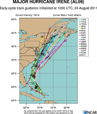
There are now several models showing Irene's center passing just east of the Outer Banks. Keep in mind Irene is a large storm and even if the storm's center passes just east of the Outer Banks much of coastal North Carolina will still be impacted by the storm. Tropical storm force winds (40mph+) extend up to 200 miles from the storm's center.

A track directly over the Outer Banks as a strong category 2 or category 3 storm would not only bring damaging winds and flooding rains to that area, but it would create overwash from the ocean and sounds. A track just to the east may not be quite as devastating but would still produce hurricane force winds (75mph+) along the Outer Banks along with heavy rain and some overwash. Gusts up to 100mph cannot be ruled out especially near Hatteras.

Based on the latest forecast track, here's what we expect for other areas in North Carolina:

Crystal Coast (Atlantic Beach, Emerald Isle, Morehead City)


  • Outer rain bands from Irene arrive Friday. Rain, which could be heavy at times, will continue Friday night and into Saturday.

  • Tropical storm force winds are possible Friday night and Saturday. Wind gusts up to 60 to 65mph possible. Could see a higher gust at Cape Lookout.


Wilmington, Jacksonville, and the Cape Fear Coast (Topsail Beach, Wrightsville Beach, Carolina Beach, Oak Island, Holden Beach, Ocean Isle)


  • Outer rain bands from Irene arrive Friday. Rain will continue Friday night into Saturday. Heavy downpours are possible at times.

  • Tropical storm force winds are possible Friday night and Saturday. Gusts up to 50mph possible.
Wilson and Goldsboro


  • Scattered showers and a few storms are possible Friday afternoon and Saturday.

  • Sustained winds 10-25mph expected with on occasional gust up to 30 or 35mph possible Saturday.

Triangle and Sandhills (Raleigh/Durham/Chapel Hill and Fayetteville)


  • Minimal impacts from Irene

  • Scattered showers and storms are possible Friday afternoon with some rain possible Saturday. However, some locations may see very little if any rain.

  • Sustained winds: 10-20mph with an occasional higher gust.


Irene will quickly move away from the North Carolina coast late Saturday night and early Sunday. The storm will quickly accelerate up the east coast and could track over or near Long Island, New York as a hurricane Sunday.

All of the expected mentioned in this post could change if there is a change in the forecast track. A jog just a little to the west or to the east could change the expected impact in your area. Stay tuned to News 14 Carolina and Weather on the Ones for the latest information.

Lee Ringer
News 14 Carolina Meteorologist
www.facebook.com/LeeRingerNews14
www.twitter.com/LeeRingerNews14

Monday, August 22, 2011

Hurricane Irene -- Monday AM Update


Hurricane Irene is strengthening this morning as it pulls away from Puerto Rico. It appears the storm will brush past the Dominican Republic and Haiti over the next day. As the center of the storm tracks just to the north of Hispaniola, it will not likely be impacted by the mountainous terrain of that island. Often when storms track directly over Hispaniola, they weaken. This is not likely to happen with Irene. With the storm staying just north of the island, it is expected to maintain its strength or continue to strengthen.

As the storm tracks over the Bahamas and just east of Florida, conditions may be favorable for rapid strengthening from mid to late week. This morning's forecast from the National Hurricane Center has Irene as a strong category 2 storm by the end of the week. That is a conservative forecast, and Irene could certainly be stronger. Coastal residents should always prepare for a storm that is at least one category stronger than forecast.

It is still much too early to make a call on an exact location for landfall for the storm in the southeastern US. A look at the computer models posted below shows uncertainty from Florida to here in North Carolina.

It does appear the storm could make landfall somewhere from Florida to the Outer Banks. Even if Irene makes landfall around Georgia or southern South Carolina, the remnants of the storm could still track over North Carolina this weekend.

A lot could and likely will change with Irene's forecast over the coming days. There is still plenty of time to monitor the latest forecasts. Everyone in the Carolinas should have their preparedness plan and be ready to act later this week if necessary.

Stay tuned to News 14 Carolina and news14.com for updates. You can tune in for our tropical updates at :21 and :51 after the hour.


Lee Ringer
News 14 Carolina Meteorologist
www.facebook.com/LeeRingerNews14


Thursday, August 18, 2011

Trouble Brewing in the Tropics?


We're watching two areas in the the tropics today. The first disturbance located in the Caribbean south of Cuba is becoming better organized this morning and could become our next tropical depression or tropical storm later today or tomorrow. Most models take that system toward Central America.

The disturbance that is of more interest to our area is way out in the Atlantic - just under 900 miles west of the Cape Verde Islands. While we don't expect any development of that disturbance today, conditions should become favorable for development as it moves to the west over the coming days. Some computer models, including the GFS shown below, forecast this becoming a tropical system and tracking toward the U.S. by late next week.


We should note this is just one run of one computer model, but the GFS has been fairly consistent over the last couple of days showing this storm approaching the U.S. As expected, with this more than a week away, it has not been consistent with exactly where the storm would go. A lot will likely change with its forecast over the coming days. No one should take this forecast and say a hurricane will definitely threaten the U.S. next week. It is just a note to pay attention to the tropics over the coming days.


We'll keep you posted with our tropical updates at :21 after the hour. Stay tuned to News 14 Carolina.


Lee Ringer
News 14 Carolina Meteorologist
www.facebook.com/LeeRingerNews14
www.twitter.com/LeeRingerNews14


Wednesday, August 10, 2011

A Break from the Heat?

It has been a very hot summer in the Carolinas including several days at or above 100. There are now signs we'll get a break from the extreme heat into much of next week. The extended outlook for the next 6 to 10 days from the Climate Prediction Center has near to below normal temperatures for most of the east coast including North Carolina.


We average highs in the upper 80s to near 90 through mid-August. At an early glance, I would anticipate highs in the mid and upper 80s for much of next week with morning lows in the 60s. That sure beats the upper 90s to near 100! Of course, errors in forecasting grow with time, so this long range forecast is not a guarantee. It is nice to say for now that we may get through next week with highs below 90!

The news isn't so good for the central U.S. where the summer has been even hotter than here. The above normal temperatures will likely continue there next week. Much of Texas including Dallas should continue their streak of 100+ degree days.


Lee Ringer


Friday, August 05, 2011

Will Emily Redevelop?

Tropical Storm Emily fell apart Thursday afternoon as it was tracking over Haiti. What remains of the system is just a disorganized area of low pressure that is tracking toward the Bahamas. While we don't expect the storm to redevelop today, some redevelopment is possible Saturday. The National Hurricane Center says there is a 60% chance it could become a tropical depression or tropical storm again.

Even if Emily redevelops, the storm is expected to stay offshore...
The only impacts in North Carolina would be the danger of rip currents at our beaches. Scattered afternoon storms are still possible this weekend, but those are unrelated to what is now the remnants of Emily.

For the latest on the tropics, tune in for our tropical updates at :21 after the hour on News 14 Carolina.

Lee Ringer
News 14 Carolina Meteorologist
www.facebook.com/LeeRingerNews14
www.twitter.com/LeeRingerNews14


Thursday, August 04, 2011

Tropical Storm Emily - Thursday AM Update

Not a lot has changed with the thinking on the forecast for Tropical Storm Emily. As of this morning, the storm was just on the south side of Haiti and the Dominican Republic. Emily has been nearly stationary for a while but is expected to move to the west-northwest to the northwest later today. That will take the storm across parts of Haiti and eastern Cuba tonight through early tomorrow. It could weaken some as it interacts with land and some wind shear.


Emily should track over the Bahamas into the weekend where conditions will be favorable for strengthening. The storm is then expected to turn to the north and eventually to the northeast Sunday.


A few models still show the storm tracking toward the Gulf of Mexico, but that appears to be an unlikely scenario at this time. Emily could become a category 1 hurricane as it tracks just of the Carolina coast. On this track, it will stay far enough offshore that even locations along the immediate coast will not see rain from the storm. Scattered afternoon thunderstorms are possible this weekend, but are not related to Emily. The only impact from the storm in North Carolina may be from rough surf and dangerous rip currents.


We still must watch Emily carefully, if the storm were to track just a little closer to the coast, the forecast could still change significantly. Stay tuned to our tropical updates at :21 and :51 after the hour on News 14 Carolina for the latest.


Wednesday, August 03, 2011

Tropical Storm Emily - Wednesday AM Update


There have not been any big changes in Tropical Storm Emily since Tuesday evening. As of the 8am update from the National Hurricane Center, the storm still has sustained winds around 50mph and is expected to pass near or over the Dominican Republic and Haiti late today and tonight. Hispaniola is a mountainous island, which should weaken the storm. There are some cases where a storm falls apart all together, but most models do not show that happening at this time.

It will be important to monitor how well Emily stays together after passing over Haiti and the Dominican Republic. Once it emerges over the Bahamas late Thursday and Friday, conditions will be favorable for strengthening. In fact, several models now show Emily becoming a hurricane off the southeast coast this weekend. The next tricky part of the forecast becomes the track Emily takes and how close it comes to the coast.
Most models now turn Emily to the northeast Sunday taking it off the Carolina coast, but not all of the models agree just how far offshore the storm will track. At this time, I do not anticipate any impacts from Emily in central North Carolina including the Triangle and Sandhills. Impacts along the coast will all depend on the exact track. A track close to the coast would bring rain and wind. If the storm stays farther offshore, the only impacts would be rough surf and rip currents. As with any tropical system, the track and intensity forecast could change over the coming days changing the forecast impacts on our area. If you have beach plans this weekend, I would not cancel them yet, just stay alert to the latest forecast.

Scattered afternoon storms unrelated to Emily are still possible this weekend.

Be sure to stay tuned to News 14 Carolina for the latest forecast. We'll have tropical updates at :21 and :51 after the hour through the week.

Lee Ringer
News 14 Carolina Meteorologist
www.twitter.com/LeeRingerNews14
www.facebook.com/LeeRingerNews14


Tuesday, August 02, 2011

Tracking Emily - Tuesday Morning Update


Tropical Storm Emily formed Monday evening and, so far, has maintained its strength as a minimal tropical storm with sustained winds of 40mph. It will likely be tough for the storm to strengthen all that much over the next couple of days. It may encounter shear and dry air that could limit strengthening today, and then it will track over or close to the Dominican Republic and Haiti. The island of Hispaniola is a mountainous region that sometimes rips apart tropical systems. Emily will likely at least weaken as it tracks over or close to Haiti and the Dominican Republic.

The official forecast track from the National Hurricane Center brings Emily over the Bahamas around the end of the week where it could strengthen as it tracks close to the southeast coast of the U.S. this weekend.

It's important to note there is uncertainty with the track and intensity forecast late this week and this weekend. While most models keep the storm just off the southeast coast, a few others actually take the system into the Gulf of Mexico.


There are even a couple models that weaken Emily all together. It is much too early to make a call if Emily will threaten North Carolina. Everyone from the Florida Gulf coast to the coast of the Carolinas should watch for the latest updates on Emily. Here in North Carolina, tune in for our tropical updates at :21 after the hour for the latest forecast.


Lee Ringer
News 14 Carolina Meteorologist