
Raleigh record highs --
- Sunday, January 14 -- 75 (1995)
- Monday, January 15 -- 74 (1960)
Greensboro record highs --
- Sunday, January 14 -- 68 (1995)
- Monday, January 15 -- 73 (1960)
And while we are enjoying this spring like weekend, it certainly feels much more like winter in other parts of the country. A significant winter storm continues from Texas to Oklahoma through Missouri and all the way to Illinois.
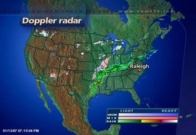
Another wave of moisture will move into the south central U.S. Sunday and Monday bringing more ice to Texas and Oklahoma. Locations as far south as San Antonio, Texas could deal with freezing rain and sleet by Monday. Winter weather will also spread toward Chicago and toward New England. Travel trouble spots Sunday and Monday will likely include Dallas/Fort Worth, Oklahoma City, Tulsa, Saint Louis, Chicago, and Boston.
This same storm is also spreading heavy rains from East Texas through the Ohio Valley. The rain will be slow to move toward North Carolina. By the time it gets here late Monday night and Tuesday, most spots will see just see scattered light showers possibly resulting in less than a tenth of an inch.
Look for more January like temperatures here in North Carolina Tuesday afternoon and Wednesday.
No comments:
Post a Comment