
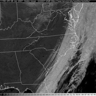
Skies are in the process of clearing out in Central and Eastern North Carolina as drier weather will rule the roost most of this workweek. That wasn't the case the first week of 2007 as Mother Nature picked up right where 2006 left off- rainfall totals in many locations are once again surging above average.
- Raleigh: 1.65"
- Fayetteville: 0.88"
- Greensboro: 1.64"
- Charlotte: 2.15"
- Asheville: 2.82"
As the clouds break apart and move away from the Carolinas we can look forward to colder air making a comeback beginning tonight. A digging trough in the Eastern U.S. will allow for cold weather fans to unite in celebration.

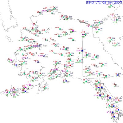
Here's a look at one computer model clearly showing cold air dipping far along the East Coast. This is the first time in a few weeks where colder air has broken the strangle hold warm temperatures have had on the Eastern United States. This week we'll have overnight lows on Wednesday and Thursday in the 20s!
This is encouraging to see as I have quite a collection of winter clothes in my closet collecting dust. Honestly, we need cold air mixing from the poles to attempt to reach a balance in the atmosphere. If it stayed warm for the rest of winter, artic air would build up in Alaska and Canada- freezing our friends up north. ***I'm confident though that this building cold air would find a way to balance out. Nature hates to remain imbalanced for too long.*** Back on topic, it's common this time of year to have warmer air moving from the equator and colder air sliding down from the poles. We're just used to being on the receiving end of the colder air more often than the warmer. This mixing is also what makes spring and fall so active as we see large swings in warm temps versus cold temps from time to time- and an increase in severe weather.
Speaking of Alaskan temperatures there are signs the weather is getting very cold up north. I see a lot of negative numbers as Arctic air is growing colder. There are signs that a piece of this air mass is ready to move south. I'd say once we get to the middle of the month we'll be talking about much colder weather for the Northern U.S. It's still yet to be seen if this same cold air pocket will make it this far Southeast. As we get farther into January and February the sun angle is on the rise in the Northern Hemisphere and the sunshine will be able to moderate the air mass more efficiently than in late December and early January.
No comments:
Post a Comment