
- Fayetteville: 64
- Raleigh-Durham: 64
- Smithfield: 64
- Goldsboro: 63
- Louisburg: 63
- Lumberton: 63
- Southern Pines: 63
- Burlington: 62
- Chapel Hill: 62
- Asheboro: 61
- Erwin: 61
- Greensboro: 61
- Henderson-Oxford: 61
- Lexington: 61
- Rocky Mount-Wilson: 61
- Winston-Salem: 61
- Mount Airy: 57
Unfortunately, this warm up will not continue. Of course, that's good news if you like the cold weather because much colder temperatures are in store for early next week.
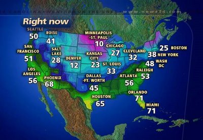
The above graphic shows temperatures across the country at 7pm Saturday evening. Notice the 10 degree reading in Minneapolis. Colder air is building in the north and will push toward North Carolina tomorrow and tomorrow night. While it will not get as cold as 10 degrees, some spots could drop to the upper teens to low 20s Monday and Tuesday mornings. Tuesday morning looks to be the coldest of the week ahead.
Looking for snow? There's no real signs that we'll see any over the next several days. A low pressure along the Gulf coast tonight will track toward the Carolina coast early Sunday morning. That will bring rain showers to eastern North Carolina but it will arrive before the cold air gets here. The front that will usher in the colder air will pass through the state tomorrow as well. That may wring out some left over moisture late Sunday afternoon and evening, but that would only produce a few snow flurries if anything at all. We'll watch for a few snowflakes late Sunday, but don't hold your breath.
Computer models continue to show a storm system tracking toward the state late in the week. It appears temperatures at that point will warm up somewhat, so any precipitation then would be in the form of rain. Of course, things can change between now and then. We'll continue to fine tune our forecast as needed. Stay tuned...
No comments:
Post a Comment