
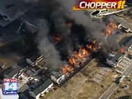
Thursday turned into a frightening day for fires in North Carolina. At least two fires engulfed homes and apartments in Wake County. One of which was a major blaze on the north side of Raleigh displacing residents and charing everything in its path. From all reports, the scene was chaos and left firefighters in a defensive stance against the flames.
There was an ideal set up for something of this horrific nature to take shape. We certainly cannot anticipate a large fire like this to happen, but on days like today it can occur more easily than others. It was dry, warm, and there wasn't much moisture in the atmosphere. However, the last ingredient made for a monster of a firestorm- wind.
Winds through North Carolina were whipping from 20-30 miles per hour with gusts as high as 35-40 mph! When you take such strong winds, throw in relative humidities as low as 10-15% the perfect breeding ground for fires is set. Forecasters along with the National Weather Service can anticipate these conditions and the NWS will issue what is known as a Red Flag Warning.
At 2:35 Thursday afternoon the Weather Service issued a Red Flag Warning. Some of the text included with the warning is as follows...
A RED FLAG WARNING MEANS THAT CRITICALIt's important to pay attention to what is happening on dry and windy days. You'll usually hear us say do not conduct any open burning and be careful using open flames. As always, never throw cigarettes out of a moving car. Fires can begin at a moments notice on a day like today. Stay tuned to News 14 Carolina and The Weather On The Ones forecast for more details on our current weather and when conditions are expected to improve.
FIRE WEATHER CONDITIONS ARE OCCURRING
AND ARE EXPECTED TO CONTINUE. A COMBINATION
OF STRONG WINDS...LOW RELATIVE HUMIDITY...
AND WARM TEMPERATURES WILL CREATE EXPLOSIVE
FIRE GROWTH POTENTIAL.
No comments:
Post a Comment