

 An update on the North Carolina Drought Monitor (http://www.ncdrought.org/) was released today, and it is really no surprise that the area of moderate drought has been extended to include the Triangle and the Triad. The rainfall deficit for Raleigh-Durham now stands at over 4 inches and almost 4 inches in the Triad. Other parts of the state have even higher rainfall deficits like Lumberton where the airport is over 10 inches below normal for the year.
Some relief may be on the way for late in the weekend and early next when at least scattered showers and thunderstorms are in the forecast. There is a chance the rainfall could be heavier and more widespread than just a few scattered showers and thunderstorms. That all depends in a disturbance in the Caribbean this Thursday that is forecast to move toward the Gulf of Mexico.
 As we mentioned yesterday, there is still some uncertainty with this system including its track and whether or not it develops into a tropical system. Computer models are still not in agreement on how to handle the disturbance. The NAM model still shows a low developing in the eastern Gulf and then bringing it through the southeastern U.S.
 This solution would bring welcomed soaking rains to the drought stricken southeast including Georgia and northern Florida. This path would eventually bring heavier rains into our area by Sunday.
Another model, the GFS model is not so optimistic for the heavier rains. That model takes the disturbance across Florida and into the Atlantic. This more easterly path would take the heavier rains away from the Carolinas, and we would only see scattered afternoon thunderstorms Sunday. We'll continue to track the latest weather data and how this system may impact our area of North Carolina. Stay tuned to Weather on the Ones on News 14 Carolina for the very latest.
 Over the past few days, some computer models have been hinting at a disturbance developing in the eastern Gulf of Mexico by the weekend. With the official start of the 2007 hurricane season Friday, we'll have to watch this disturbance for signs of tropical development.


 Another significant storm that had a major impact on North Carolina was Hurricane Floyd in 1999.
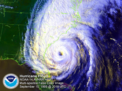 Hurricane Floyd was also a category 2 storm when it made landfall along the North Carolina coast. The biggest problem from Floyd was from the storm's heavy rains over eastern North Carolina. Rain totals as high as 15 to 20 inches were reported in some locations. The flooding from Floyd was so extensive it could be seen on satellite --


