
It was another busy day and night in the Weather on the Ones forecast center Thursday as we tried to stay one step ahead of the developing storms. We received several reports of hail and even some wind damage across portions of the News 14 Carolina viewing area. Below, is a map of severe weather reports provided by the Storms Prediction Center for May 18, 2006.
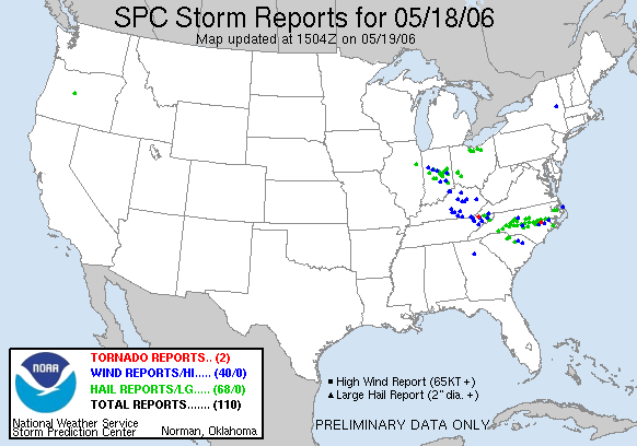 You'll notice a lot of the severe weather across the U.S. on Thursday was right here in North Carolina. The green dots represent reports of large hail. The blue dots represent wind damage. If you look close enough (you may need to click on the image to open a better view), you'll see one red dot in the state. That indicates a tornado. An eyewitness reported a brief tornado touchdown around 8:45pm near La Grange in Lenoir County.
Here's a look at some selected severe weather reports in and around the News 14 Carolina viewing area --
- 6:15pm -- Golfball size hail reported by the fire department near Highfalls in Moore County.
- 6:20pm -- Nickel size hail reported by law enforcement near Robbins in Moore County
- 6:29pm -- Half inch size hail reported by a trained spotter along Jordan Lake in Chatham County
- 6:45pm -- Penny size hail reported by a trained spotter at the US 15/501 and US 1 split in Lee County
- 6:45pm -- Penny size hail reported by a trained spotter in Cary
- 7:00pm -- Penny size hail reported by law enforcement in Carthage
- 7:02pm -- Pea size hail reported by a trained spotter at the intersection of New Hope Rd. and New Bern Ave. in Raleigh
- 7:05pm -- Reports of trees down just north of Carthage
- 7:10pm -- Nickel size hail reported by law enforcement just west of Angier in Harnett County
- 7:10pm -- Penny size hail reported by a trained spotter in Southern Pines
- 7:20pm -- Penny size hail reported near Vass in Moore County
- 7:30pm -- Penny size hail reported near Spring Lake in northern Cumberland County
- 7:41pm -- 72mph wind gust reported by a trained spotter near Exit #319 on I-40.
- 7:50pm -- Penny size hail reported by law enforcement in Four Oaks in Johnston County
- 8:04pm -- Quarter size hail reported by a trained spotter 10 miles east of Smithfield in Johnston County
- 8:05pm -- Half dollar size hail reported by law enforcement 3 miles southwest of Princeton in Johnston County
- 8:06pm -- Penny size hail reported by law enforcement one mile southeast of Princeton in Johnston County
- 8:06pm -- Penny size hail reported by law enforcement 3 miles southeast of Princeton in Wayne County
- 8:07pm -- Quarter size hail reported by a trained spotter in Princeton in Johnston County
- 8:10pm -- Golf ball size hail reported by law enforcement in Princeton in Johnston County
- 8:11pm -- Penny to nickel size hail reported by law enforcement in downtown Princeton in Johnston County
- 8:12pm -- Penny size hail reported by a trained spotter in the Rosewood area of Wayne County
- 8:25pm -- Dime size hail reported by a trained spotter in Goldsboro
- 8:30pm -- Penny size hail reported by a trained spotter in Pikeville in Wayne County
- 8:40pm -- Law enforcement reported trees down near Mount Olive in Wayne County
So how have recent rains helped with our drought situation across the state? There is some good news on that front. Take a look at the latest drought map released yesterday --
 The yellow color represents areas considered to be "abnormally dry." The light brownish color represents a moderate drought, and the sliver of darker brown you see represents a severe drought. If you remember back a few weeks ago, parts of central North Carolina were under a severe drought. That was dropped a couple of weeks ago, and this latest drought update has slightly shrunk the size of the moderate drought. If we could only continue to see a round of rain (without the severe weather!) every several days, we could continue making a dent in the drought. You can read more about the latest drought update by visiting www.ncdrought.org
Let me wrap things up for this post by looking ahead to the weekend. We do stand a chance to pick up some showers and even a few thunderstorms very late Friday night and early Saturday morning. As of early this afternoon, most indications show that most of this rain should move out of region shortly after daybreak Saturday. That will give way to partly cloudy skies by mid-morning and highs reaching near 80 in the afternoon. Of course, we'll keep you posted of any changes to that forecast with Weather on the Ones.
If you're looking for something to do this weekend, Gary has some great ideas in the post below. If your Saturday plans bring you to the Animal Planet Expo tomorrow in Cary, stop by and say hello!
Enjoy your weekend!
-Lee Ringer
No comments:
Post a Comment