Why did we receive so much rain here? It was not because the storm stalled out or was moving slower. It actually picked up speed in its movement across the Carolinas. The real reason was a frontal boundary set up across North Carolina. You'll remember a few disturbances riding along a front this past weekend that led to strong to severe storms. That same boundary was hanging out over the state on Wednesday and helped focus heavier rain amounts directly over central North Carolina.
Raleigh and Wake County experienced some of the heaviest rainfall of the entire area. Here's a county by county break down of Alberto's rainfall --
Chatham
- Jordan Dam -- 5.31"
- Siler City -- 1.68"
- Wilsonville -- 5.16"
Cumberland
- Fayetteville Airport -- 2.98"
- Fayetteville -- 3.03"
Franklin
- Louisburg -- 5.17"
Granville
- Oxford -- 1.96"
Harnett
- Angier -- 3.45"
- Erwin/Dunn -- 2.51"
Hoke
- Raeford -- 3.47"
Johnston
- Clayton -- 2.77"
- Smithfield -- 2.53"
Moore
- Southern Pines -- 4.97"
- Woodlake -- 3.67"
- Carthage -- 3.42"
Orange
- Chapel Hill -- 1.62"
- Chapel Hill Airport -- 1.56"
Vance
- Henderson -- 1.86"
Wake
- Raleigh National Weather Service Office (NC State) -- 7.16"
- Garner -- 7.05"
- Apex -- 7.01"
- Holly Springs -- 7.00"
- North Raleigh -- 6.29"
- Cary -- 5.89"
- Knightdale -- 5.70"
- RDU Airport -- 5.65"
- Barton Creek -- 5.64"
Wayne
- Goldsboro -- 2.40"
Wilson
- Wilson -- 3.94"
While there is no rain in the forecast through the rest of the week and the weekend, we will likely see scenes that remind of Alberto for the next several days and in some cases weeks. Take a look at this photo a News 14 Carolina viewer e-mailed us from southern Granville County.
 That's a picture of Woodland Church Road that was washed out from Wednesday's rains.
It's also important to remember that all the water from Alberto's rains has to drain off somewhere. Lakes, rivers, and streams will be higher than normal for the coming days. Some rivers and streams will remain over their banks. You can check out the latest river flooding warnings here -- http://newweb.erh.noaa.gov/ahps2/index.php?wfo=rah
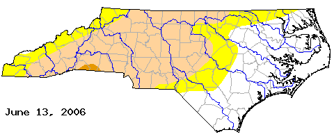
Now to a question that many folks have been asking -- does all this rain mean we are out of a drought? We often say that it takes a tropical system bringing large rain amounts to help out with a North Carolina drought. If there was any benefit to Alberto, it was its help in alleviating the drought. Here's the latest drought monitor released today --

Points from Raleigh to the east are no longer under drought conditions. Locations to the west or Raleigh are still under a moderate drought. The areas shaded in yellow including a large part of Wake County and some surrounding areas indicate "abnormally dry" conditions.
I don't think anyone who saw Crabtree Creek out of its banks on Wednesday would say Raleigh is abnormally dry. However, there are a few things to keep in mind when thinking about our drought status. A drought does not happen overnight; it takes months and months to build up. Because of that a drought does not go away in one day. A lot of the heavy rains from Wednesday will wash away in rivers and streams meaning not all of it soaks into the ground. With that said, Alberto's rains have made a sizable dent in the dry conditions that have built up in our area over the last year.

No comments:
Post a Comment