
Can you believe today is the last day of June? The year is half over! Many people are gearing up for an extended weekend with the 4th of July coming up Tuesday, and its shaping up to be a typical summer weekend in North Carolina. Temperatures and the humidity will increase slightly for Saturday and Sunday. Highs will likely reach the low to mid 90s. When you factor in the humidity, it will feel more like the upper 90s or even as hot as 100.
Rain chances will be slim to none the next couple of days. There is a very small chance that an isolated afternoon shower could pop up Saturday or Sunday afternoon. Since the chance is so small, we are pretty safe to say it will just be partly cloudy and hot. Scattered afternoon storms return to our outlook by Tuesday.
If you have travel plans across the state this weekend, weather should not be a problem for you. Highs will reach the mid 80s in the mountains and the upper 80s to near 90 along the coast.
If you are staying at home, it should be a great weekend to check out 4th of July events around the region. Click the following link for --
Friday, June 30, 2006
Thursday, June 29, 2006
Drought? What Drought?
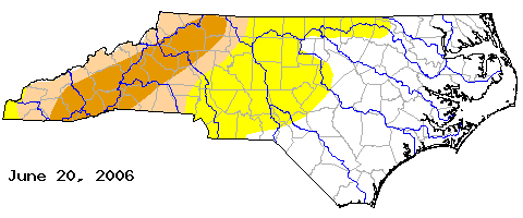
The weekly update on North Carolina's drought status was released today. As you likely expected with record June rainfall in Raleigh, the drought size has shrunk.
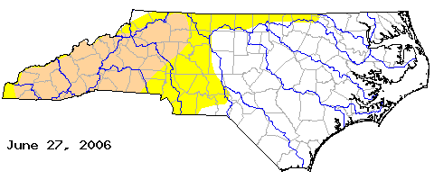 The drought is pretty much all gone across the News 14 Carolina viewing area. However, extreme northern Granville, Vance, and Warren Counties are considered to be "abnormally dry." A moderate drought continues for western North Carolina, but parts of that region had been under a severe drought just last week.
We may see a few isolated thunderstorms this Thursday afternoon to add to our rain totals. After today, our rain chances will be slim to none through the weekend.
Wednesday, June 28, 2006
Wettest June Ever at RDU
This afternoon's Weather 101 question -- When did RDU record the wettest June?
That's somewhat of a trick question since the answer is this year -- 2006! With the rains we have seen over the past couple of days, this year has surpassed June 1973 when the airport measured 9.38". As of midday Wednesday, the June 2006 rainfall at RDU was at 10.45" So much for that drought earlier this year!
Here's some interesting links from the National Weather Service:
By the way, if you have something you would like to see in our Weather on the Ones blog, let us know by sending an e-mail to weather@news14.com
Tuesday, June 27, 2006
Afternoon Update
I don't anticipate the NHC will make anything out of the low that's moving up the Carolina coastline Tuesday. We're also beginning to see the heavy rain and storms breaking apart as well. Rainfall totals in certain areas will be high, but the widespread areas accumulating a few inches or more of rain looks unlikely. That's a good thing considering we were very worried about a repeat of some of the scenes from Alberto two weeks ago.
Here are some selected cities and their rainfall totals from Tuesday...
New Bern: 0.87"
Cape Hatteras: 1.05"
Raleigh: 0.57"
Fayetteville: Trace
Greensboro: 2.36"
Charlotte: 0.69"
Asheville: 0.34"
Willmington: 0.49"
Lumberton: 0.01"
Here are some selected cities and their rainfall totals from Tuesday...
New Bern: 0.87"
Cape Hatteras: 1.05"
Raleigh: 0.57"
Fayetteville: Trace
Greensboro: 2.36"
Charlotte: 0.69"
Asheville: 0.34"
Willmington: 0.49"
Lumberton: 0.01"
Watching the Tropics Close to Home
From the NHC this morning...
Satellite and radar information continue to indicate that a small low pressure system could be forming about 140 miles south- southwest of Cape Lookout North Carolina. This system has become better organized today... And potential remains for it to develop into a tropical depression or a tropical storm at any time as the system moves north to north-northeastward at about 20 mph. An Air Force reserve reconnaissance aircraft is on the way to investigate the system later this morning and afternoon to determine if a closed circulation exists at the surface. Residents along the North Carolina and Virginia coasts should closely monitor the progress of this system today as tropical storm warnings could be required. Even if this system does not form into a tropical cyclone, showers and thunderstorms producing locally heavy rainfall and Strong gusty winds will gradually spread onshore the North Carolina and Virginia coasts today and tonight.
Satellite and radar information continue to indicate that a small low pressure system could be forming about 140 miles south- southwest of Cape Lookout North Carolina. This system has become better organized today... And potential remains for it to develop into a tropical depression or a tropical storm at any time as the system moves north to north-northeastward at about 20 mph. An Air Force reserve reconnaissance aircraft is on the way to investigate the system later this morning and afternoon to determine if a closed circulation exists at the surface. Residents along the North Carolina and Virginia coasts should closely monitor the progress of this system today as tropical storm warnings could be required. Even if this system does not form into a tropical cyclone, showers and thunderstorms producing locally heavy rainfall and Strong gusty winds will gradually spread onshore the North Carolina and Virginia coasts today and tonight.
Sunday, June 25, 2006
Flooding Potential

Over the last couple of days, we've kept a close eye on a tropical wave just north of the Bahamas. That tropical wave is not showing signs of becoming a tropical depression right now, but it is bringing a lot of tropical moisture to Florida, Georgia and the Carolinas. Combine that deep tropical moisture with a stalled out front to our west, and parts of central North Carolina could be dealing with some flooding over the next day or two.
Just about a week and a half ago, what was left of Tropical Storm Alberto made its way along a stationary front across North Carolina. We've all either experienced the flooding or seen pictures of the flooding that caused across Raleigh. Now, we cannot say we will see similar sights from this current weather setup, but flooding is certainly a possibility. If you live in a flood prone or low-lying area, please keep this in mind. Also, be cautious while driving. Unfortunately, most flooding deaths occur when someone tries to drive across a flooded roadway. It only takes a small amount of water to wash away a car or truck. The National Weather Service has a great saying when it comes to encountering a flooded roadway, "Turn around, don't drown!"
As of Sunday evening, the National Weather Service has posted a Flash Flood Watch for much of central North Carolina through Tuesday. Two to four inches of rain is possible from Sunday through Tuesday. Some locations that experience the heavier downpours could measure over six inches. We'll keep you posted with the latest weather advisories on News 14 Carolina.
You can let us know how much rain you have seen and send us pictures of any flooding in your area by e-mailing us at weather@news14.com
Thursday, June 22, 2006
Wet Weather Pattern Ahead?
You'll probably remember back the first part of the year when it seemed like the only thing a meteorologist in central North Carolina could talk about was the drought. At one point this spring, we were over 6 inches behind in rainfall at RDU. Alberto took care of all of that last week. The latest drought monitor this week has dropped the drought status for all of central North Carolina. Although, locations west of the Triangle are considered to be "abnormally dry." Western North Carolina has been placed under moderate to severe drought.
It appears we are in the midst of at least a temporary weather pattern shift from the drought to wet weather. Our friends over at the National Weather Service Forecast Office in Raleigh sent an e-mail to local meteorologists this week letting us know that we have had the second wettest June on record for RDU with 8.41" so far. The wettest June on record at RDU was in 1973 when the airport recorded 9.38" With about a week left in the month, we may top that total.
A front will approach North Carolina this weekend and will likely become stationary over our region Sunday and remain stalled out across the state through early next week. At the same time, a tropical wave now located northeast of the Bahamas will bring tropical moisture to the southeast by late in the weekend and early next week. That tropical moisture will interact with that stalled out front to give us an increased chance for showers and thunderstorms. Most of that activity would likely come during the heating of the day, or mainly during the afternoon and evening. With all that tropical moisture around, those showers and storms will likely produce heavy downpours.
Speaking of the tropical wave to the northeast of the Bahamas, the tropical outlook from the National Hurricane Center stated that pressures in that region of the tropics were beginning to drop. That can be the first sign of tropical development. The tropical wave is not looking very impressive on satellite this evening, and conditions are not too favorable for development tonight. However, that may change over the next day or so.
We'll keep you posted with the latest in our Weather on the Ones updates on News 14 Carolina. Stay tuned!
Wednesday, June 21, 2006
Summer Storms for the First Day of Summer
The first day of summer brought stormy weather to parts of central and eastern North Carolina. An impulse in the mid to upper levels of the atmosphere helped to kick off a couple storms around Wake County during the lunch hour. As those storms moved to the southeast, they encountered a very unstable atmosphere thanks to the intense heating. That led to a few strong to severe storms.
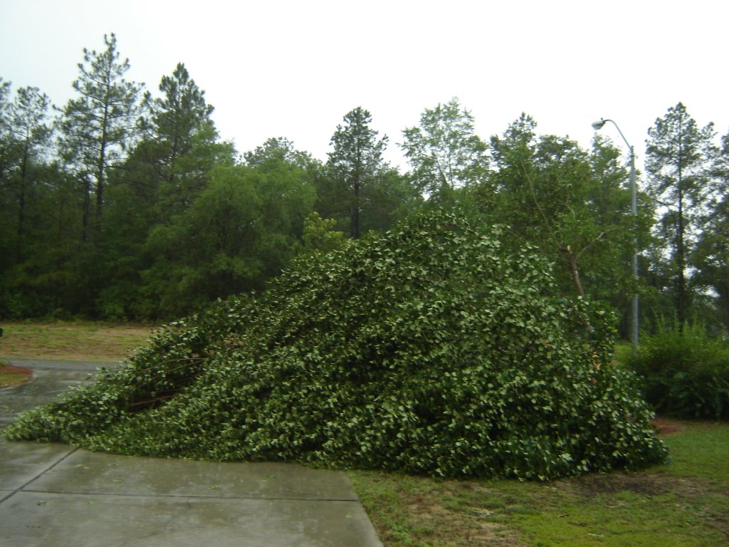
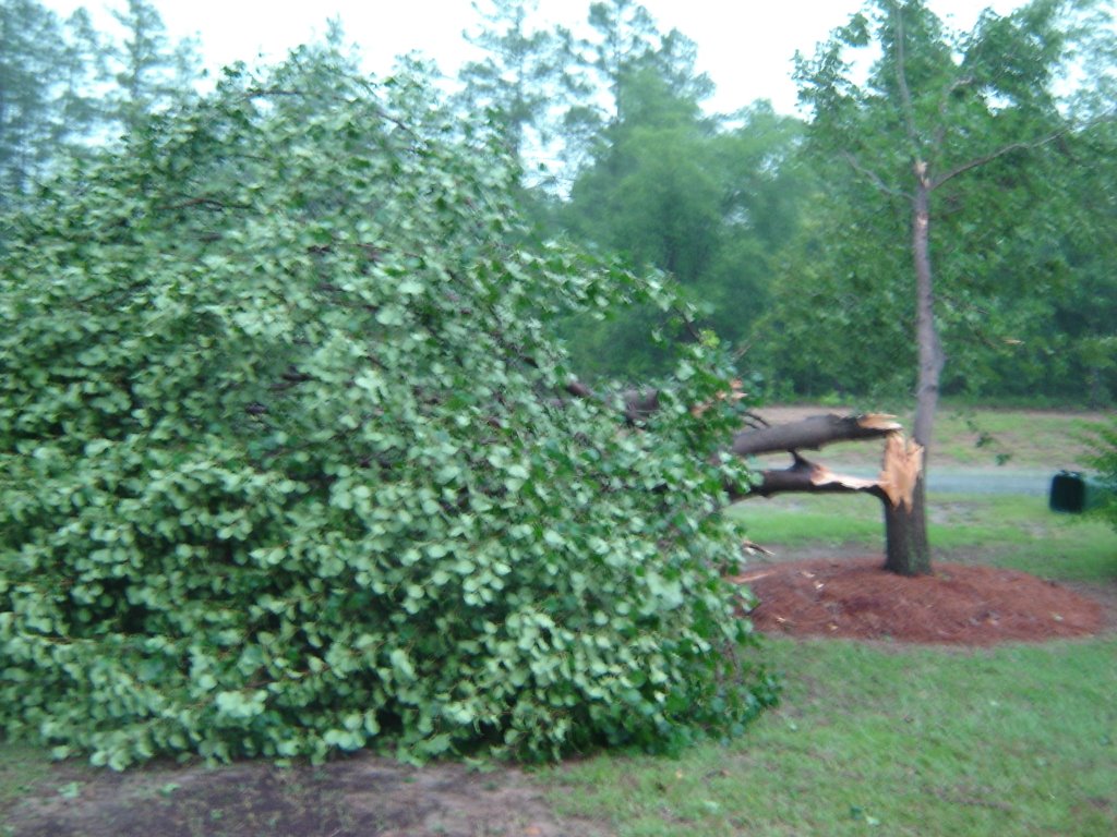
Some of the thunderstorms produced winds powerful enough to knock trees and power lines in some neighborhoods. Susan, a News 14 Carolina viewer near Eastover in Cumberland County, sent us these pictures of a tree toppled from the thunderstorm winds.

 Here's a listing of storm reports passed along by the National Weather Service on Wednesday --
Some of the thunderstorms produced winds powerful enough to knock trees and power lines in some neighborhoods. Susan, a News 14 Carolina viewer near Eastover in Cumberland County, sent us these pictures of a tree toppled from the thunderstorm winds.
 Here's a listing of storm reports passed along by the National Weather Service on Wednesday --
- 1:50pm -- Trees down north of Black Creek in Wilson County. Report from law enforcement.
- 1:50pm -- Law enforcement reported trees down near Clayton in Johnston County.
- 1:55pm -- Several trees down north of Benson in Johnston County. Report from law enforcement.
- 2:00pm -- Trees blown down by thunderstorm winds near Fremont in Wayne County. Report from emergency management.
- 2:20pm -- Trees down near Princeton in Wayne County. Report from law enforcement.
- 2:38pm -- Law enforcement reported numerous trees and power lines down in and around Goldsboro
- 2:45pm -- House fires reported by law enforcement in Wayne County. Fire locations include Saulston, Mount Olive, and Patetown
- 3:35pm -- Power lines down near Eastover in Cumberland County
- 4:25pm -- Penny size hail reported by law enforcement near Rockfish in Hoke County.
- 4:50pm -- Trees and power lines down on US Highway 15-501 near Aberdeen in Moore County. Law enforcement also had spotty reports of trees down across Moore County
Hot summer weather will continue for the rest of the week, and at least a few isolated afternoon thunderstorms could go along with that hot weather. Stay tuned to News 14 Carolina. We'll keep you updated with Weather on the Ones!
Summer Begins Today!
Well, here I am looking at the clock, and it reads 8:26am. The exact time we bid a fond farewell to Spring, which ended on a very strong note in terms of rainfall. It would've been nicer to see it a little more gradual rain than the deluge we had one week ago today with what was left of Tropical Storm Alberto!
The Summer Solstice today marks the northernmost movement of the direct rays of the sun, reaching the Tropic of Cancer at approximately 23 degrees north latitude (roughly the latitude of Havana, Cuba). This marks the day where the sun will shine longer in the Northern Hemisphere than at any other time of the year as well, and within weeks we will begin losing daylight by the minute or two until the shortest day of the year, December 21 - the Winter Solstice.
Enjoy all the sunshine today... and all 15 hours and 36 minutes of visible light in the sky!
Sunday, June 18, 2006
More on Alberto's Flooding Rains
The National Weather Service Forecast Office has released their event summary on the flooding rains from Alberto on Wednesday, June 14. You can check it out by clicking to --
http://www4.ncsu.edu/~nwsfo/storage/cases/20060614/
http://www4.ncsu.edu/~nwsfo/storage/cases/20060614/
Thursday, June 15, 2006
Wednesday's Flooding
Wednesday was quite the busy day in the Weather on the Ones forecast center as we tracked Alberto and the flooding rains the storm caused in central North Carolina. Alberto was never a very powerful storm as far as wind speeds go. It was just a tropical storm when it made landfall along Florida's Gulf Coast. Damage was fairly minimal as far as tropical systems go in Florida. Many times these weaker tropical systems actually cause more problems inland, and that was the case for Alberto. In fact, the storm dumped more rain in central North Carolina than it did on Florida.
Why did we receive so much rain here? It was not because the storm stalled out or was moving slower. It actually picked up speed in its movement across the Carolinas. The real reason was a frontal boundary set up across North Carolina. You'll remember a few disturbances riding along a front this past weekend that led to strong to severe storms. That same boundary was hanging out over the state on Wednesday and helped focus heavier rain amounts directly over central North Carolina.
Raleigh and Wake County experienced some of the heaviest rainfall of the entire area. Here's a county by county break down of Alberto's rainfall --
Chatham
 That's a picture of Woodland Church Road that was washed out from Wednesday's rains.
It's also important to remember that all the water from Alberto's rains has to drain off somewhere. Lakes, rivers, and streams will be higher than normal for the coming days. Some rivers and streams will remain over their banks. You can check out the latest river flooding warnings here -- http://newweb.erh.noaa.gov/ahps2/index.php?wfo=rah
Now to a question that many folks have been asking -- does all this rain mean we are out of a drought? We often say that it takes a tropical system bringing large rain amounts to help out with a North Carolina drought. If there was any benefit to Alberto, it was its help in alleviating the drought. Here's the latest drought monitor released today --
Why did we receive so much rain here? It was not because the storm stalled out or was moving slower. It actually picked up speed in its movement across the Carolinas. The real reason was a frontal boundary set up across North Carolina. You'll remember a few disturbances riding along a front this past weekend that led to strong to severe storms. That same boundary was hanging out over the state on Wednesday and helped focus heavier rain amounts directly over central North Carolina.
Raleigh and Wake County experienced some of the heaviest rainfall of the entire area. Here's a county by county break down of Alberto's rainfall --
Chatham
- Jordan Dam -- 5.31"
- Siler City -- 1.68"
- Wilsonville -- 5.16"
Cumberland
- Fayetteville Airport -- 2.98"
- Fayetteville -- 3.03"
Franklin
- Louisburg -- 5.17"
Granville
- Oxford -- 1.96"
Harnett
- Angier -- 3.45"
- Erwin/Dunn -- 2.51"
Hoke
- Raeford -- 3.47"
Johnston
- Clayton -- 2.77"
- Smithfield -- 2.53"
Moore
- Southern Pines -- 4.97"
- Woodlake -- 3.67"
- Carthage -- 3.42"
Orange
- Chapel Hill -- 1.62"
- Chapel Hill Airport -- 1.56"
Vance
- Henderson -- 1.86"
Wake
- Raleigh National Weather Service Office (NC State) -- 7.16"
- Garner -- 7.05"
- Apex -- 7.01"
- Holly Springs -- 7.00"
- North Raleigh -- 6.29"
- Cary -- 5.89"
- Knightdale -- 5.70"
- RDU Airport -- 5.65"
- Barton Creek -- 5.64"
Wayne
- Goldsboro -- 2.40"
Wilson
- Wilson -- 3.94"
While there is no rain in the forecast through the rest of the week and the weekend, we will likely see scenes that remind of Alberto for the next several days and in some cases weeks. Take a look at this photo a News 14 Carolina viewer e-mailed us from southern Granville County.
 That's a picture of Woodland Church Road that was washed out from Wednesday's rains.
It's also important to remember that all the water from Alberto's rains has to drain off somewhere. Lakes, rivers, and streams will be higher than normal for the coming days. Some rivers and streams will remain over their banks. You can check out the latest river flooding warnings here -- http://newweb.erh.noaa.gov/ahps2/index.php?wfo=rah
Now to a question that many folks have been asking -- does all this rain mean we are out of a drought? We often say that it takes a tropical system bringing large rain amounts to help out with a North Carolina drought. If there was any benefit to Alberto, it was its help in alleviating the drought. Here's the latest drought monitor released today --

Points from Raleigh to the east are no longer under drought conditions. Locations to the west or Raleigh are still under a moderate drought. The areas shaded in yellow including a large part of Wake County and some surrounding areas indicate "abnormally dry" conditions.
I don't think anyone who saw Crabtree Creek out of its banks on Wednesday would say Raleigh is abnormally dry. However, there are a few things to keep in mind when thinking about our drought status. A drought does not happen overnight; it takes months and months to build up. Because of that a drought does not go away in one day. A lot of the heavy rains from Wednesday will wash away in rivers and streams meaning not all of it soaks into the ground. With that said, Alberto's rains have made a sizable dent in the dry conditions that have built up in our area over the last year.
Wednesday, June 14, 2006
Raleigh Flooding
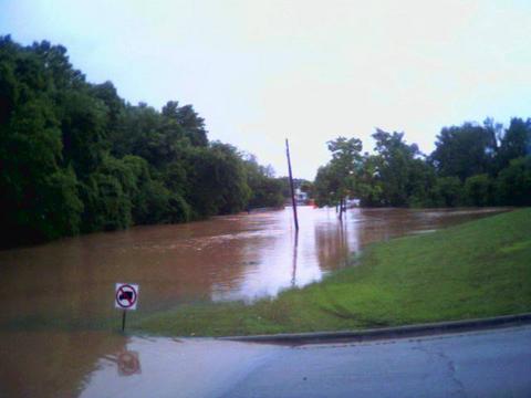 Here's a photo I just took on my cell phone of flooding just outside News 14 Carolina's offices on Atlantic Avenue in Raleigh. That is Crabtree Creek that has jumped it's banks near the intersection of Atlantic Avenue and Hodges Street. Crabtree Creek is also causing extensive flooding in the Crabtree Valley Mall area of Raleigh.
 See more flooding photos by clicking here or visiting news14.com.
Here's a look at rainfall totals as of 2pm --
- Raleigh National Weather Service Office (NCSU Centinnial Campus) -- 7.60"
- Apex -- 6.66"
- RDU Airport -- 5.61"
- North Raleigh -- 5.50"
- Cary -- 5.23"
- NE Raleigh -- 5.00"
- Vass -- 4.18"
- Southern Pines -- 3.51"
- Pope Air Force Base -- 3.51"
- Fayetteville -- 2.98"
- Chapel Hill 1.50"
- Goldsboro -- 1.42"
You can e-mail rain reports and your flooding pictures to weather@news14.com.
Tune to News 14 Carolina for the latest flooding updates from around central North Carolina.
Alberto Flooding in NC

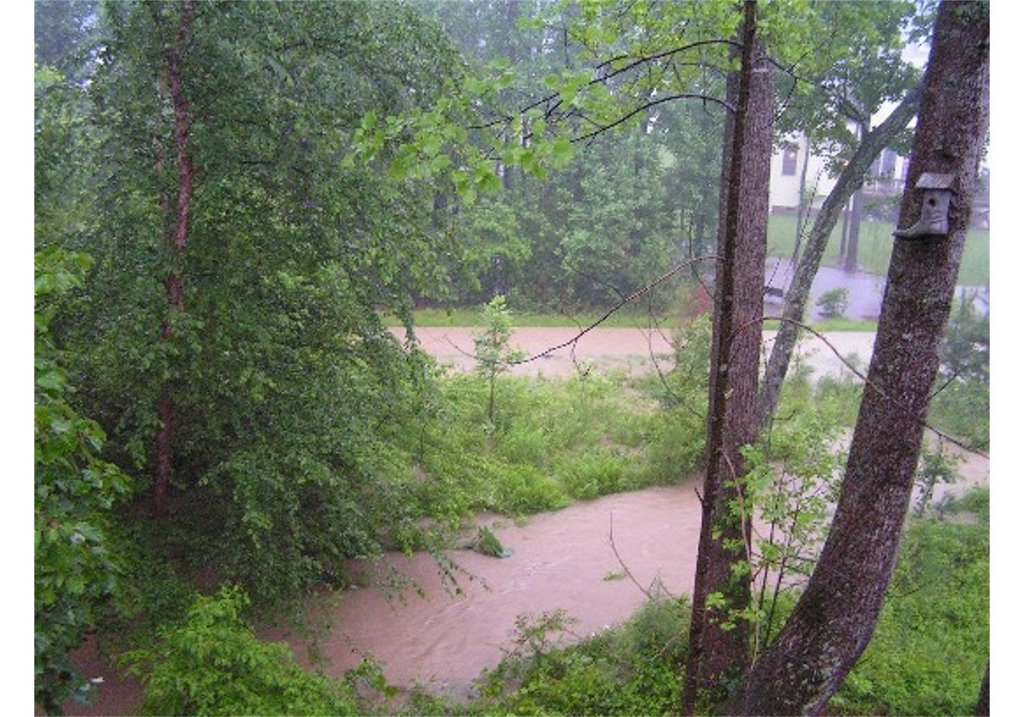
Tropical Depression Alberto is creating some problems for central North Carolina this Wednesday morning, especially when it comes to flooding. The above pictures were sent in by Robin Jones, a News 14 Carolina viewer in Cary. Robin says the 2 foot wide waterway behind her home has grown to include the entire greenway and some backyards in her neighborhood.
As of 9am, here's a look at rainfall totals across the area --
- Wadesboro -- 5.10"
- Apex -- 3.14"
- Sanford -- 2.04"
- Fayetteville -- 1.79"
- Southern Pines -- 1.76"
- RDU Airport -- 1.63"
We are beginning to receive several reports of flooding across the Triangle. Stay tuned to News 14 Carolina for the latest updates.
If you have rain reports of pictures from your neighborhood, you can share them with us by e-mailing weather@news14.com.
Monday, June 12, 2006
Stormy Sunday Evening
It was another busy night in the Weather on the Ones Forecast Center. Here's a look at some of the storm reports from around the region on June 11, 2006 --
- 8:30pm -- Numerous trees reported down in Pittsboro from Chatham County law enforcement
- 8:30pm -- Trees reported down along US Highway 1 near Moncure in Chatham County. Report from trained storm spotter.
- 8:45pm -- Another report from a trained storm spotter of trees down in Moncure and Corinth in Chatham County.
- 8:45pm -- Law enforcement reported a tree down near Harper House Rd. south of the Bentenville area of Johnston County
- 8:55pm -- Public report of a tornado near Harris Lake in southwestern Wake County.
- 9:01pm -- Public reports of numerous trees down south of Holly Springs near the Wilbon area of Wake County
- 9:05pm -- Law enforcement reported a tree down on Cokesbury Rd. in northern Harnett County
- 9:05pm -- Law enforcement reported a tree down on Atkins Rd. in Harnett County near the Wake County line. An automobile hit the tree in the road. No injuries were reported.
- 9:05pm -- Law enforcement reported power lines down on Matthews Road near Highway 401 north of Lillington in Harnett County.
- 9:05pm -- Law enforcement reported trees down on Wyndham Place Drive off of Rawls Church Road near Angier in Harnett County.
- 9:06pm -- Trained storm spotter reported pea size hail on Vorhees Lane south of Holly Springs in Wake County.
- 9:10pm -- Trained storm spotter reported penny size hail and wind gusts to 45mph near US Highway 401 and Ten Ten Road south of Raleigh.
- 9:15pm -- Trained storm spotter reported a large tree down blocking Piney Grove-Wilbon Road southwest of Fuquay-Varina in Wake County.
- 9:15pm -- Trained storm spotter reported 2 inches of rain in an hours time near US 15 and 501 in Chatham County.
- 9:20pm -- Trained storm spotter reported flooding at US Highway 401 and Simpkins Road near Colonial Heights in the Garner area of Wake County.
- 9:20pm -- Public report of penny size hail in the Princeton area of Johnston County.
- 9:25pm -- Law enforcement reported penny size hail near Cleveland in Johnston County.
- 9:25pm -- Trained spotter reported penny size hail near Wayne Memorial Drive and and US Highway 70 in Goldsboro
- 9:29pm -- Trained storm spotter measured a wind gust of 65mph near Garner in Wake County.
- 9:35pm -- Penny size hail reported on I-40 between Exits 319 and 312 in Johnston County.
More strong storms are possible across parts of the News 14 Carolina viewing area this Monday afternoon and evening. In addition to the chance for storms, we're keeping a close eye on Alberto. For the latest, tune to News 14 Carolina for weather updates every 10 minutes.
Alberto = Good for Florida?
Not even two full weeks into the 2006 Atlantic Basin hurricane season and Alberto is on its way to Florida (by the way, it is an "it" not a "he!" - that is a pet peeve of mine!). While Florida has been ravaged in the past couple of years by a substantial number of storms, this one might be a benefit to the state which has been hit hard by wildfires in 2006.
Just a few examples of rainfall deficits compared to normal thus far in Florida in 2006... Melbourne -6.79", Orlando -8.64", Daytona Beach -10.21". With this slow moving tropical storm expected to drop anywhere from 5 to 10 inches of rainfall on these and other dry areas, while at the same time not intensifying to a hurricane, this may be a net gain for the state. By Wednesday, some of these deficits may be surpluses!
The best news is Alberto looks to move northeasterly out of Florida and be a non-issue in North Carolina, with the exception of some rain along the coast of our state late Wednesday into early Thursday.
Be careful with some of those storms today (which have nothing to do with Alberto, BTW!)!
Saturday, June 10, 2006
Tropical Depression One
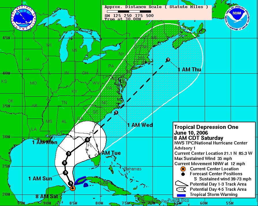
The first system of the 2006 season is slowly gaining strength this Saturday over the western Caribbean. Winds are near 35 mph with a forward motion to the north-northwest at 12 mph. We'll be following the development and motion of this system very closely. You can see from the first five day tracking chart issued from the TPC shows the Crystal Coast and the Outer Banks may be brushed Tuesday or Wednesday of this week.
Remember though that this is just a guide based on a possible path. There is a lot of time before now and then, so changes are anticipated.
Friday, June 09, 2006
Possible Tropical Development
 All eyes will be on the tropics this weekend as we could see the first tropical system of the 2006 Atlantic hurricane season develop. The above image is a satellite picture taken Friday evening. You'll notice the flare up of thunderstorms in the northwestern Caribbean. This is an infrared satellite image, so the darker reds indicate colder cloud tops. Those colder cloud tops typically equate to stronger storms.
The National Hurricane Center (NHC) reported late this afternoon that pressures are falling in this area of disturbed weather, and that is an indication that this system may be getting stronger. The NHC has scheduled a hurricane hunter aircraft to fly into the storm Saturday afternoon to obtain more data.
Several forecast models bring this system into the Gulf of Mexico over the weekend and toward the U.S. Gulf coast. It is too early to say exactly how strong this system could become. It's also too early to say exactly where it may be headed. However, there is the possibility that it could impact the Gulf coast by early next week. If that is the case, it could then move northeast bringing rain to parts of the southeast.
There are a lot of "what ifs" with this system. Stay tuned to News 14 Carolina and we'll keep you posted with the latest. You can catch the latest tropical update at :21 after the hour every hour.
Thursday's Storms

Thursday afternoon and evening brought another round of scattered strong thunderstorms across central and eastern North Carolina. The above picture is one of the storms photos sent to weather@news14.com by Lee Lee Dunaway, a News 14 Carolina viewer in Fayetteville. We received several reports of wind damage, hail, and fires caused by lightning from around the region. Here's a look at some of the storm damage reports in and around the News 14 Carolina viewing area --
- 4:02pm -- Pea to nickel size hail covered the ground on Old Whiteville Road southeast of Lumberton in Robeson County. Report from a trained storm spotter.
- 5:10pm -- Pea size hail reported near Raeford in Hoke County. Report from law enforcement.
- 5:30pm -- Trees down along Highway 20 southeast of Raeford in Hoke County. Report from law enforcement.
- 6:09pm -- Trees down from thunderstorm winds near exit 14 on I-95 in Robeson County. Reported by the National Weather Service.
- 6:15pm -- Numerous house fires from lightning strikes reported across Cumberland County by local law enforcement.
- 6:48pm -- Numerous trees down in the Coats area of Harnett County. Report from a county official.
- 7:13pm -- Tree snapped from a thunderstorm wind gust 10 miles north of Newton Grove in Johnston County. Reported by a trained storm spotter.
- 7:38pm -- Several trees reported down in the Princeton area of Johnston County. Report from a county official.
The only storms in the state this Friday afternoon are a couple of isolated thunderstorms near the Outer Banks. Quiet weather should continue into the first half of the weekend. However, a couple of disturbances moving through the state could bring more thunderstorms late Saturday night or early Sunday morning and another round for late Sunday.
We'll keep you posted on News 14 Carolina.
Tuesday, June 06, 2006
Tuesday's Storms
Tuesday afternoon brought another scattering of showers and thunderstorms across central and eastern North Carolina. Our weather was influenced by an area of low pressure in the mid and upper levels of the atmosphere. One way to think of this is an area of cool air in the mid to upper levels of the atmosphere. As the sun came out Tuesday morning and midday, it helped to heat the surface. The cooler air located above the warmer surface created instability and that aided in the formation of storms.
That cooler air aloft also created lower freezing levels, which means it's a little easier for hail to form in thunderstorms. We did hear several reports of hail across the region. Here's a look at some of the storm reports from around the News 14 Carolina viewing area --
That cooler air aloft also created lower freezing levels, which means it's a little easier for hail to form in thunderstorms. We did hear several reports of hail across the region. Here's a look at some of the storm reports from around the News 14 Carolina viewing area --
- 3;30pm -- Penny size hail reported by the public west-northwest of Youngsville in Franklin County
- 3:45pm -- Marble size hail reported by a trained spotter near the intersection of Garret and Old Chapel Hill Road in Durham
- 4:13pm -- Dime size hail reported by the Franklin County Police Department just west of Louisburg
- 4:17pm -- Golf ball size hail reported by law enforcement 2 miles northeast of Louisburg in Franklin County
- 4:25pm -- Penny size hail reported by a trained storm spotter near I-85 and US Highway 158 in Granville County
- 4:30pm -- Penny size hail reported by the public near New Hill in Wake County
- 4:50pm -- Pea size hail reported in Raven Rock State Park in Harnett County by a park employee
- 4:54pm -- Penny size hail reported by a trained storm spotter near the intersection of US 64 and Rolesville Road in Wake County near Wendell
- 5:00pm -- News 14 Carolina viewer reported near golf ball size hail in eastern Wake County. The viewer reported hail covering the ground
- 5:21pm -- Pea size hail reported by law enforcement near the junction of NC Highway 42 and US Highway 70 in Clayton in Johnston County
- 5:23pm -- Penny size hail reported by the public near Clayton in Johnston County
- 5:25pm -- Penny size hail reported by law enforcement near the I-85 and I-40 split in Orange County
If you have pictures of the Tuesday's hail storms, you can share them with us by e-mailing them to weather@news14.com
We should get a break from the afternoon showers and storms on Wednesday. However, scattered afternoon thunderstorms should return for Thursday. We'll keep you posted on Thursday's thunderstorm chance on News 14 Carolina.
Monday, June 05, 2006
A Few Storms on Monday, More Possible Tuesday
With afternoon heating this Monday, we saw a few thunderstorms pop-up over central and eastern North Carolina. A couple of those became strong at times. Here's a look at some of the severe weather reports in and around the News 14 Carolina viewing area --
- 3:35pm -- Penny size hail reported near Goldston in southern Chatham County
- 4:00pm -- Several reports of penny size hail just west of Sanford in Lee County
- 5:09pm -- Report of a person struck by lightning near the Olivia community in Harnett County. Extent of the injuries were unknown.
- 5:35pm -- Penny size hail reported just north of Spring Lake on North Bragg Blvd. near the Harnett/Cumberland County line.
In addition to these reports, there were other reports of severe weather east of the News 14 Carolina viewing area closer to coastal locations in North Carolina.
We expect to see more scattered showers and thunderstorms Tuesday afternoon. An area of low pressure in the mid to upper levels of the atmosphere should help to kick off some of these storms. You can think of a mid to upper level low as an area of cool air in the mid to upper levels of the atmosphere. During the daytime hours Tuesday, the sun will warm the surface. That cool air over the warming surface temperatures, will create instability over our region. That will create some fuel for a scattering of showers and thunderstorms.
If you have outdoor plans Tuesday afternoon, keep an eye to the sky. Remember a basic safety rule when it comes to thunderstorms -- if you hear thunder, you are close enough to the storm to be struck by lightning. If storms develop, we'll be in the Weather on the Ones forecast center with radar updates every 10 minutes.
Friday, June 02, 2006
Wet Start to the Weekend?
Some locations in the News 14 Carolina viewing area can expect a wet start to the weekend. Scattered showers and thunderstorms have developed this afternoon across the state. The atmosphere over the region is fairly moist and a bit unstable. That means some of the storms could produce localized heavy downpours. There is also the possibility that a few storms may become strong at times.
The showers and storms are developing ahead of an approaching cold front. That front will move through North Carolina slower that first anticipated. That will keep showers and even a few thunderstorms in the forecast through at least the first half of Saturday. The rain will end west to east across our area. Many of us should see some sunshine by the afternoon hours.
For the latest radar updates and more on your weekend outlook, tune to News 14 Carolina. We'll be hear with weather updates every 10 minutes!
Thursday, June 01, 2006
Thursday Afternoon Weather Update
If you read my blog post from yesterday, I mentioned that the Storm Prediction Center (SPC) had placed parts of central North Carolina under a "slight risk" for severe weather for Friday. This morning, the SPC dropped that slight risk for our state and pushed it a little to the north into parts of Virginia and the Mid-Atlantic states on Friday. That's where dynamics in the atmosphere may be a little more favorable for stronger storms. As of Friday morning, they placed coastal North Carolina under a slight risk for severe storms Saturday. You can find these forecasts including any updates by clicking the following link --
http://www.spc.noaa.gov/products
With that said, we are still looking for showers and thunderstorms late Friday. Even though the slight risk was dropped, we still may have one or two strong storms. A cold front will be moving through the state bringing that increased chance for showers and storms. The latest weather data coming in today suggests the front may be a little slower to move through than first thought. If that is the case, our best chance for rain will come late Friday afternoon, evening and Friday night. We may see some rain showers linger Saturday morning especially for locations east of I-95. If you are headed to the beach this weekend, the front is now expected to hang out along the coast Saturday afternoon keeping showers and storms in the forecast for coastal areas.
In other news, can you believe that it's already June? That, of course, means the start of hurricane season for the Atlantic basin. The tropics are fairly quiet on this first day of the 2006 season, which is not too surprising. The season typically starts with very little action. If we were to see any tropical development in June, it normally would come from the Gulf of Mexico. that changes later in the season. We have a while to go as hurricane season does not end until November 30. The season usually peaks in September.
Speaking of hurricane season, mark your calendar for Saturday, June 17. News 14 Carolina along with the American Red Cross will host a hurricane preparedness fair at Triangle Town Center in Raleigh. We'll have more on the event as we get closer to the date. You can also read more by clicking this link --
Before the Storms: 2006
Subscribe to:
Posts (Atom)