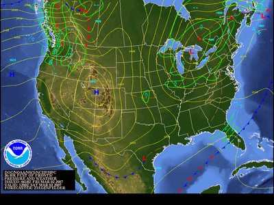
With the passage of a cold front the threat for stormy weather has ended in North Carolina. Cooler, drier air will begin to slide in to the Tar Heel State this afternoon and allow for windy conditions. This weekend is shaping up to be pleasant, but not a mild as recent days. A look at Saturday's surface map shows the upper level low which initiated all the severe weather over the Deep South hanging out over the Great Lakes. As it continues to spin it will spark snow showers through the Upper Midwest.
A little closer to North Carolina we'll see a shift to Northwesterly flow at the surface and aloft. This means cooler weather and a return to below average temperatures for the first full weekend of March. A gradual warm up is in the forecast this work week, but it appears after Saturday we won't return to the 60's until at least midweek. Overnight lows will be a little on the chilly side as most areas will experience nighttime temps below freezing. That means a couple of frosty mornings- so even though you may let your office or house plant soak up the sun be sure to bring it in at night.
Along those lines, I've already had a few people asking about early season planting and it's still a little early as our average last freeze is still more than a month away. According to the NWS Raleigh, the average last freeze for the viewing area normally occurs between April 1st-12th. So, if you've got a backyard garden hang tight for a couple more weeks.

No comments:
Post a Comment