
 Scattered strong thunderstorms developed up and down the east coast again Wednesday afternoon. The above image shows various severe weather reports received by the National Weather Service. The blue dot indicate reports of large hail and the green dots represent wind damage reports.
In the News 14 Carolina viewing area here's a look back at severe weather reports from Wednesday --
- 12:45pm -- News 14 Carolina viewer reported 0.25" to 0.5" size hail near the Cary/Apex line.
- 12:55pm -- Penny size hail reported at Knightsplay Gold Course in Apex.
- 12:55pm -- Half inch size hail reported in Harnett County near Lillington.
- 1:20pm -- Penny size hail reported near New Hope Church Road and Yates Store Road in eastern Chatham County.
- 1:58pm -- Nickel size hail reported near Lillington in Harnett County.
- 2:43pm -- Penny size hail reported just north-northeast of Eastover in Cumberland County.
- 3:01pm -- Penny size hail reported near Hope Mills Golf Course in Cumberland County.
- 3:17pm -- Penny to nickel size hail reported covering the ground in Lumberton.
- 3:20pm -- Hail to the size of "large pecans" reported on 5th street in Lumberton.
- 4:03pm -- Penny size hail reported near McCain on Highway 211 in Hoke County.
Scattered showers and thunderstorms are possible in parts of North Carolina again Thursday. Cloudy skies through the day will limit the chance for strong storms over the Triangle and Sandhills. We will likely just look for cloudy conditions with a few showers possible. The greatest risk of strong storms will come from near Charlotte to the west and south. The Storm Prediction Center (SPC) has placed that area under a slight risk for severe weather:

The unsettled weather pattern looks to continue into the weekend. That will keep skies cloudy for Friday with a few showers possible. It appears the risk for strong storms will again come south of the Triangle. As of Thursday afternoon, the SPC has parts of South Carolina outlined under a slight risk for severe weather.

More sun should return for Saturday but a few afternoon thunderstorms could pop up. As of Thursday afternoon, the SPC has central and eastern North Carolina outlined for a slight risk for severe weather.
The chances for showers and storms should diminish by Father's Day. Sunday will bring mostly sunny skies with highs back to the 90s. We'll continue to fine tune the forecast into the weekend over the next couple of days. For the latest on the severe weather risk, you can visit the Storm Prediction Center's website at http://www.spc.noaa.gov/, and stay tuned to Weather on the Ones on News 14 Carolina!


 Over the past few days, some computer models have been hinting at a disturbance developing in the eastern Gulf of Mexico by the weekend. With the official start of the 2007 hurricane season Friday, we'll have to watch this disturbance for signs of tropical development.


 Another significant storm that had a major impact on North Carolina was Hurricane Floyd in 1999.
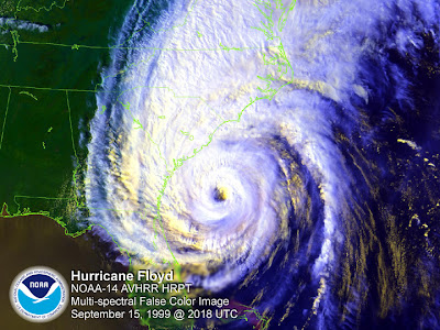 Hurricane Floyd was also a category 2 storm when it made landfall along the North Carolina coast. The biggest problem from Floyd was from the storm's heavy rains over eastern North Carolina. Rain totals as high as 15 to 20 inches were reported in some locations. The flooding from Floyd was so extensive it could be seen on satellite --


