Thursday, June 14, 2007

Wednesday's Storms

Scattered strong thunderstorms developed up and down the east coast again Wednesday afternoon. The above image shows various severe weather reports received by the National Weather Service. The blue dot indicate reports of large hail and the green dots represent wind damage reports.

In the News 14 Carolina viewing area here's a look back at severe weather reports from Wednesday --


  • 12:45pm -- News 14 Carolina viewer reported 0.25" to 0.5" size hail near the Cary/Apex line.
  • 12:55pm -- Penny size hail reported at Knightsplay Gold Course in Apex.
  • 12:55pm -- Half inch size hail reported in Harnett County near Lillington.
  • 1:20pm -- Penny size hail reported near New Hope Church Road and Yates Store Road in eastern Chatham County.
  • 1:58pm -- Nickel size hail reported near Lillington in Harnett County.
  • 2:43pm -- Penny size hail reported just north-northeast of Eastover in Cumberland County.
  • 3:01pm -- Penny size hail reported near Hope Mills Golf Course in Cumberland County.
  • 3:17pm -- Penny to nickel size hail reported covering the ground in Lumberton.
  • 3:20pm -- Hail to the size of "large pecans" reported on 5th street in Lumberton.
  • 4:03pm -- Penny size hail reported near McCain on Highway 211 in Hoke County.

Scattered showers and thunderstorms are possible in parts of North Carolina again Thursday. Cloudy skies through the day will limit the chance for strong storms over the Triangle and Sandhills. We will likely just look for cloudy conditions with a few showers possible. The greatest risk of strong storms will come from near Charlotte to the west and south. The Storm Prediction Center (SPC) has placed that area under a slight risk for severe weather:

The unsettled weather pattern looks to continue into the weekend. That will keep skies cloudy for Friday with a few showers possible. It appears the risk for strong storms will again come south of the Triangle. As of Thursday afternoon, the SPC has parts of South Carolina outlined under a slight risk for severe weather.

More sun should return for Saturday but a few afternoon thunderstorms could pop up. As of Thursday afternoon, the SPC has central and eastern North Carolina outlined for a slight risk for severe weather.

The chances for showers and storms should diminish by Father's Day. Sunday will bring mostly sunny skies with highs back to the 90s. We'll continue to fine tune the forecast into the weekend over the next couple of days. For the latest on the severe weather risk, you can visit the Storm Prediction Center's website at http://www.spc.noaa.gov/, and stay tuned to Weather on the Ones on News 14 Carolina!

Sunday, June 10, 2007

Saturday's Storms


Saturday was a stormy evening in parts of the Triangle as a few isolated severe storms pounded the area with rain, hail, gusty winds, and frequent lightning. The above pictures were taken by Chief Meteorologist Gary Stephenson as the storm clouds rolled into Wake County Saturday evening.

The storms did not produce widespread damage, but there were a few reports of downed trees and hail. Gary also took these photos of trees down along Carpenter Pond Road in eastern Durham County. The trees also brought down utility poles knocking out power in the area for around 12 hours.


Here's a rundown of severe weather reports passed along by the National Weather Service --

  • 8:10pm -- Quarter size hail reported in Berea in Granville County
  • 9:00pm -- Quarter size hail reported south of Butner in Granville County
  • 9:10pm -- Trees down across Kemp Road in eastern Durham County
  • 9:10pm -- Penny size hail reported near Norwood Road and Mount Vernon Road northwest of Raleigh in Wake County
  • 9:10pm -- Trees down in the Stony Hill area of Wake County
  • 9:15pm -- Tree down across Old Erwin Road in eastern Durham County
  • 9:20pm -- Tree down across Carpenter Road in eastern Durham County
  • 9:25pm -- Tree down across Cornwallis Road in eastern Durham County
  • 9:45pm -- Nickel size hail reported near I-40 west-northwest of Parkwood in Durham County

News 14 Carolina viewers also passed along reports of hail, gusty winds, and frequent lightning from the storms. If you ever see severe weather of have weather pictures, you can send us an e-mail anytime to weather@news14.com.

Saturday, June 09, 2007

Friday's Heat

Friday was the hottest day so far this year in most places around central North Carolina. Here's a look back at high temperatures for selected locations around our region --
  • Erwin/Dunn: 97
  • Lumberton: 97
  • Southern Pines: 97
  • Fayetteville: 96
  • Laurinburg-Maxton: 96
  • Raleigh-Durham: 96
  • Henderson-Oxford: 95
  • Chapel Hill: 94
  • Rocky Mount-Wilson: 94
  • Burlington: 93
  • Louisburg: 93
  • Winston-Salem: 92
  • Asheboro: 91
  • Greensboro: 91
  • Lexington: 90
  • Mount Airy: 90

Not only was Friday afternoon hot, the day started off on the warm side. Record high minimum temperatures were set in the Triangle and in the Triad. Friday's low of 73 at the Raleigh-Durham Airport broke the old record of 72 set in 1947. At the Piedmont Triad Airport in Greensboro, Friday's low of 72 broke the old record of 71 set in 1953 and 1952.

Friday, June 08, 2007

Summer Heat

The heat is on in North Carolina! Highs reached the low to mid 90s Thursday and the mid to upper 90s are possible Friday afternoon.

Here's a look back at highs around the region from Thursday --
  • Fayetteville: 96
  • Goldsboro: 95
  • Laurinburg-Maxton: 94
  • Lumberton: 94
  • Raleigh-Durham: 94
  • Erwin-Dunn: 93
  • Southern Pines: 93
  • Rocky Mount-Wilson: 92
  • Louisburg: 91
  • Chapel Hill: 90
  • Henderson-Oxford: 88

Thursday, June 07, 2007

Drought Update


An update on the drought status across North Carolina was released today, and the news is a little better for the Triangle. The moderate drought has been downgraded to "abnormally dry" conditions in the Triangle and much of eastern North Carolina. The moderate drought continues in the Sandhills and Piedmont. The mountains continue under a severe to extreme drought.
Soaking rains from the remnants of Tropical Storm Barry over the weekend helped some in the eastern part of the state. However, more rain is needed.
Here's a look at year to date rainfall deficits for select locations in the state as of Thursday:
  • Lumberton: -10.26"
  • Asheville: -9.39"
  • Elizabeth City: -8.21"
  • Wilmington: -7.74"
  • Cape Hatteras: -5.54"
  • Charlotte: -3.57"
  • New Bern: -3.45"
  • Greensboro: -3.26"
  • Raleigh-Durham: -3.20"

Unfortunately, our chances for a good soaking rain over the next several days do not look good. A few scattered late day thunderstorms are possible Saturday.

Hot Here Today; Strong Storms near the Great Lakes

Around here, the big weather story is the heat as highs climb into the 90s.

Nationwide, the big weather story today is the likelihood for severe storms in the western Great Lakes region this afternoon and evening. The Storm Prediction Center (www.spc.noaa.gov) has issued a "high risk" for severe weather in that part of the country today.

A "high risk" for severe storm is not issued often, and when it is we typically see it across the Plains in tornado alley. It is rare to see a high risk in Wisconsin, but thunderstorms producing damaging winds are likely in there this afternoon with a few tornadoes also a possibility. You can read more about the severe weather threat by visiting www.spc.noaa.gov.

Here in North Carolina, there's no threat for severe storms -- just high heat. If you're spending some time outdoors today, don't forget those simple summer safety rules. Dress for the hot weather and drink plenty of water. Our hot weather with highs in the 90s should continue through the first of the weekend. A cold front is expected to move through the state Saturday. That should drop our highs back to the 80s for Sunday and the first of next week.

Stay tuned to Weather on the Ones on News 14 Carolina for updates on the heat.

Wednesday, June 06, 2007

Heating Up....

The hottest weather of the year is on the way for the end of the week. So far this year, the warmest temperature we've recorded at the Raleigh-Durham Airport was 92 on May 1 and May 29. We should beat that both Thursday and Friday when afternoon temperatures are forecast to top out in the mid 90s. The upper 90s are possible Friday. It may even feel more like 100 or 105 when you factor in the humidity.

It is a little early to be talking about temperatures this warm. The average highs this time of year are in the mid 80s. We may come close to a record high Thursday, but should fall just short. Thursday's record is 96, and Friday's record of 100 should be safe.

Thankfully, slightly cooler temperatures will be on the way by the second half of the weekend. Highs in the 80s are expected for Sunday and the first of next week.

Monday, June 04, 2007

Weekend Rain

The remnants of Barry were a welcome sight in North Carolina bringing soaking rains to many spots over the weekend. Here's a look back at rain totals by county as reported by the National Weather Service --

Alamance County
  • Burlington: 1.02"
  • Graham: 1.08"

Chatham County

  • Wilsonville: 1.61"

Cumberland County

  • Fort Bragg: 1.34"
  • Pope Air Force Base: 1.26"
  • Fayetteville Regional Airport: 1.17"

Davidson County

  • Lexington: 0.80"

Edgecombe County

  • Tarboro: 1.99"

Forsyth County

  • Winston-Salem: 1.36"

Durham County

  • Durham: 1.33"

Franklin County

  • Louisburg: 1.30"
  • Pilot: 1.75"

Guilford County

  • Greensboro: 1.04"

Harnett County

  • Erwin/Dunn: 1.39"

Johnston County

  • Smithfield: 1.39"

Moore County

  • Southern Pines: 1.47"

Nash County

  • Rocky Mount: 2.24"

Orange County

  • Chapel Hill: 1.41"

Scotland County

  • Laurinburg: 1.57"

Vance County

  • Henderson: 1.89"

Wake County

  • Apex: 1.49"
  • Cary: 1.30"
  • Fuquay-Varina: 3.73"
  • Holly Springs: 2.05"
  • NCSU Centinnial Campus: 1.68"
  • North Raleigh: 1.05"
  • Northeast Raleigh: 3.07"
  • RDU Airport (Morrisville): 1.66"

Wayne County

  • Seymour Johnson Air Force Base: 2.25"
  • Goldboro Airport: 2.25"

Wilson County

  • Wilson: 2.11"

It does not appear that we have a chance for any more soaking rains over the next few days. Our only rain chances will come in the form of very isolated late day showers or storms Tuesday and Wednesday.

Even the chance for a late day pop-up storm will diminish toward the end of the week as temperatures warm into the mid 90s. Late day rain chances should return over the weekend.

Thursday, May 31, 2007

Drought Update


An update on the North Carolina Drought Monitor (http://www.ncdrought.org/) was released today, and it is really no surprise that the area of moderate drought has been extended to include the Triangle and the Triad. The rainfall deficit for Raleigh-Durham now stands at over 4 inches and almost 4 inches in the Triad. Other parts of the state have even higher rainfall deficits like Lumberton where the airport is over 10 inches below normal for the year.

Some relief may be on the way for late in the weekend and early next when at least scattered showers and thunderstorms are in the forecast. There is a chance the rainfall could be heavier and more widespread than just a few scattered showers and thunderstorms. That all depends in a disturbance in the Caribbean this Thursday that is forecast to move toward the Gulf of Mexico.

As we mentioned yesterday, there is still some uncertainty with this system including its track and whether or not it develops into a tropical system. Computer models are still not in agreement on how to handle the disturbance. The NAM model still shows a low developing in the eastern Gulf and then bringing it through the southeastern U.S.
This solution would bring welcomed soaking rains to the drought stricken southeast including Georgia and northern Florida. This path would eventually bring heavier rains into our area by Sunday.

Another model, the GFS model is not so optimistic for the heavier rains. That model takes the disturbance across Florida and into the Atlantic. This more easterly path would take the heavier rains away from the Carolinas, and we would only see scattered afternoon thunderstorms Sunday.
We'll continue to track the latest weather data and how this system may impact our area of North Carolina. Stay tuned to Weather on the Ones on News 14 Carolina for the very latest.

Wednesday, May 30, 2007

A Pattern Change Ahead?

Over the last few days, it seems we've become stuck in a hot and dry weather pattern. It was nice weather for the Memorial Day weekend, but this weather hasn't been so nice for our lawns and gardens. There are signs that our dry pattern may change by late in the weekend and early next week.

One system we are watching is a flare up of thunderstorms today in the Caribbean moving toward the Gulf of Mexico.

Over the past few days, some computer models have been hinting at a disturbance developing in the eastern Gulf of Mexico by the weekend. With the official start of the 2007 hurricane season Friday, we'll have to watch this disturbance for signs of tropical development.

At least one computer model (NAM) today shows an area of low pressure in the Gulf Saturday --


Another computer model (GFS) for the same time Saturday takes the disturbance across Florida and into the Atlantic --


With different computer model solutions, there is still uncertainty to exactly what this system will do. If it does develop into a tropical depression or tropical storm, it may not be bad news. Soaking rains from a weak tropical system would be welcome in much of the Southeast where drought conditions continue to build.

If this disturbance develops in the eastern Gulf, it should bring rain chances to the Carolinas by Sunday. Additional moisture should stick around into the first of next week. That should give us higher rain chances through at least Monday and Tuesday.

For the latest, stay tuned to Weather on the Ones on News 14 Carolina!

Sunday, May 27, 2007

Drought Update


Drought conditions expanded across parts of the state this week. The western most portion of North Carolina is now in an extreme drought. In our part of the state, the Sandhills are in a moderate drought while the Triangle remains abnormally dry.
As of Sunday evening, here's a look at year to date rainfall deficits across the state --
  • Lumberton: -9.83"
  • Wilmington: -8.13"
  • Asheville: -7.98"
  • Cape Hatteras: -6.26"
  • New Bern: -4.43"
  • Raleigh-Durham: -3.94"
  • Greensboro: -3.38"

We don't expect any relief from the drought conditions for the next several days. Our next chance for rain won't come until next weekend when there's a slight chance for scattered afternoon thunderstorms.

As we move into the summer months, most of our rainfall will come in the form of scattered afternoon thunderstorms. These produce a short burst of rain in one neighborhood while other communities miss out on the heavier rains. Because of this, the scattered showers and storms don't help much to alleviate drought conditions.

Our only hope for some help would come from a weak tropical system that would bring beneficial soaking rains. An active hurricane season wouldn't be so bad if all the storms remained just weak systems. We certainly don't wish for damaging winds and flooding, but soaking rains could benefit much of the southeast.

The Atlantic hurricane season begins June 1, so stay tuned...


For more information on drought in North Carolina, click to www.ncdrought.org.

Sunday, May 20, 2007

Hurricane Preparedness Week

We're less than a month away from the official start of the 2007 hurricane season in the Atlantic basin, and now is the time to make sure we are all prepared. This week (May 20-26) has been set aside as Hurricane Preparedness Week. Over the coming days, you'll hear a lot about hurricane forecasts for this year and what coastal residents need to do to be prepared. It has been a while since North Carolina has been impacted by a major hurricane, but we still need to prepare for whatever may come our way this year. Even though we aren't located directly on the coast, we could still feel the affects of a tropical system here in central North Carolina.

One of the most significant tropical systems to make landfall in North Carolina in recent years was Hurricane Isabel in 2003. Isabel at one point over the Atlantic reached category 5 strength but weakened to a category 2 hurricane when it made landfall near Drum Inlet along the Outer Banks.


The strongest winds from Isabel were felt along the Outer Banks , but wind gusts over 50mph were felt in the Triangle.
Another significant storm that had a major impact on North Carolina was Hurricane Floyd in 1999.
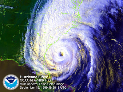
Hurricane Floyd was also a category 2 storm when it made landfall along the North Carolina coast. The biggest problem from Floyd was from the storm's heavy rains over eastern North Carolina. Rain totals as high as 15 to 20 inches were reported in some locations. The flooding from Floyd was so extensive it could be seen on satellite --


Residents of the Triangle in the 1990s will also remember Hurricane Fran that made landfall along the North Carolina coast in 1996.


Fran was strong enough to produce hurricane force wind gusts in Raleigh resulting in downed trees and powerlines across the Triangle.

Forecasts for the 2007 hurricane season are for this year to be an active one, but there is no way to know for certain if North Carolina will be impacted like we were in 2003, 1999, or 1996. The best advice is to know about hurricane dangers and stay tuned to the latest forecasts through the season, which runs through November.

Count on News 14 Carolina for the very latest information all season long. You can catch our tropical updates at :21 after the hour every hour. We'll also have more information on how you can prepare for the upcoming season this week in special reports that will air at :43 after the hour.

You can also find more information online through these links --

Thursday, May 17, 2007

Moderate Drought Extended into Sandhills


This week's drought monitor has extended the moderate drought into parts of the North Carolina Sandhills. A severe drought continues in the western most part of the state, while over parts of central and eastern North Carolina are considered to be "abnormally dry".
As of midday Thursday, here's a look at year to date rainfall deficits for selected locations in the state --
  • Lumberton: -8.63"
  • Wilmington: -7.05"
  • Asheville: -6.33"
  • Raleigh-Durham: -2.54"
  • Greensboro: -1.96"
  • Charlotte: -1.47"

It does not appear there will be much relief from the dry conditions across the state over the next several days. A few sprinkles of rain are possible Friday, but if we do see any rain, they rain totals will be very light. Dry weather is expected for the start of next week.

Wednesday, May 16, 2007

Hazy Wednesday

View from DOT camera in Durham midday Wednesday.

Does it appear hazy out your office window today? Fires several states are to blame for our hazy conditions today in North Carolina. Southwesterly winds today is spreading smoke from fires in southern Georgia and northern Florida into parts of the Carolinas.

Here's a statement issued by the National Weather Service in Raleigh this morning --

1018 AM EDT WED MAY 16 2007.

NOW...

STRONG SOUTHWESTERLY WINDS OF 35 TO 40 MPH JUST OFF THE SURFACE WILL SPREAD A SMOKE PLUME ACROSS PORTIONS OF CENTRAL NORTH CAROLINA THROUGH NOON TODAY. THE SMOKE PLUME ORIGINATES FROM WILDFIRES IN PARTS OF SOUTHEAST GEORGIA AND NORTHERN FLORIDA. AS THE AIR TEMPERATURES CONTINUES TO HEAT UP...THE SMOKE PLUME SHOULD GRADUALLY LIFT HIGHER IN THE ATMOSPHERE AND BECOME LESS CONCENTRATED. UNTIL THEN...THE SMOKE PLUME WILL CAUSE HAZY CONDITIONS... REDUCING VISIBILITY RESTRICTIONS TO 3 TO 5 MILES. PERSONS WHO SUFFER FROM ASTHMA OR OTHER BREATHING AILMENTS SHOULD LIMIT OUTDOOR EXPOSURE TODAY.

Sunday, May 13, 2007

Weekend Rain Update

Saturday brought a day of stormy weather to North Carolina. Some of the storms became severe producing gusty winds and hail. The largest hail in our area was reported in southern Granville County near Butner and Stem where 1.0" diameter hail was reported.

Saturday's storms were also slow movers dropping a lot of rain on some communities. Here's a look at rain totals from across this area this weekend --
  • NC State Centennial Campus (Raleigh): 2.06"
  • Lake Wheeler (Raleigh): 1.70"
  • Reedy Creek (Raleigh): 1.27"
  • Lumberton: 1.03"
  • Clayton: 0.96"
  • Raleigh-Durham Airport: 0.96"
  • Chapel Hill: 0.86"
  • Laurinburg-Maxton: 0.25"
  • Fayetteville: 0.19"
  • Rocky Mount-Wilson: 0.12"
  • Erwin: 0.08"

Thursday, May 10, 2007

Drought Update

There's an update on the North Carolina drought monitor this week --
The yellow shaded areas on the drought monitor map indicate "abnormally dry" conditions which encompasses much of the eastern third of North Carolina. Abnormally dry conditions can be the precursor of a drought. Drought conditions are reported in parts of western North Carolina. The darker shading in the western most corner of the state represents a severe drought.

There are rain chances in the forecast for the next few days that may help some of the dry conditions. However, the rain will be in the form of scattered afternoon thunderstorms meaning some communities see the rain while others miss out. For an idea on what locations in the state may see the scattered thunderstorms over the next few days, take a look at these computer model forecasts from the North Carolina State Climate Office --

For late Thursday afternoon/evening:

For late Friday afternoon/evening:

For late Saturday afternoon/evening:

For more information, visit these links:

Andrea Update -- Thursday

Andrea has weakened some today and is now officially a subtropical depression. The system will continue to drift to the south over the next day or so and will more than likely continue to weaken. Andrea may still bring some much needed rain to dry areas of southern Georgia and Florida.

Wednesday, May 09, 2007

Andrea update -- Wednesday evening

It's May 9th and we have the first named storm of the year. I'm sure I speak for everyone when I say that I hope this isn't a sign for a busy hurricane season ahead. The Atlantic season officially doesn't start until June 1. It's not unheard of to have a named storm in May, but it is a little unusual.

As I mentioned earlier, Andrea is a subtropical storm because it slowly gained some tropical characteristics over the next few days. The storm isn't packing much of a punch and shouldn't cause to many problems as it slowly moves toward the northern coast of Florida.

Andrea did bring additional moisture into North Carolina Wednesday afternoon. When that increase in humidity was combined with daytime heating, afternoon thunderstorms fired up. A few of those became strong prompting a few severe thunderstorm warnings in our area. We did have one report from a trained storm spotter of penny sized hail in Gorman just east of Durham. A News 14 Carolina viewer also reported pea sized hail in Fayetteville.

Those showers and storms are dying down Wednesday evening as we lose the daytime heating. We'll keep a close eye on Andrea, but don't expect too many problems with the exception of dangerous rip currents off the coast including off our coast in North Carolina.

The low pressure that eventually developed intro Andrea has battered our coast the last few days with those rip currents and high surf. Here are a few pictures News 14 Carolina viewers Thomas and Melissa Collins of Goldsboro e-mailed me from their trip earlier this week along the Outer Banks.


If you ever have any weather photos to share with us, feel free to e-mail us at weather@news14.com anytime!

First Named Storm of the Season

The low pressure system we've been tracking the past few days has now become Subtropical Storm Andrea. This makes it the first named storm of the 2007 Atlantic hurricane season forming a few weeks before the official start of the season on June 1.

The storm has slowly become a "warm core" low pressure system meaning that it has slowly gained some tropical characteristics. This is why it is referred to as a subtropical storm and not a tropical storm.

For more on Subtropical Storm Andrea, you can visit the National Hurricane Center's website at www.nhc.noaa.gov and stay tuned to News 14 Carolina for the latest.

Wednesday Morning Update -- Could it be Andrea?

Here's the latest on the low pressure off the southeast coast from the National Hurricane Center (www.nhc.noaa.gov):

SPECIAL TROPICAL DISTURBANCE STATEMENT
NWS TPC/NATIONAL HURRICANE CENTER
MIAMI FL
905 AM EDT WED MAY 9 2007

SATELLITE IMAGERY AND PRELIMINARY REPORTS FROM AN AIR FORCE RESERVERE CONNAISSANCE AIRCRAFT THIS MORNING INDICATE THAT THE AREA OF LOW PRESSURE CENTERED ABOUT 150 MILES EAST OF JACKSONVILLE IS ACQUIRING THE CHARACTERISTICS OF A SUBTROPICAL CYCLONE. THE SYSTEM CONTINUES MOVING GENERALLY WESTWARD AT ABOUT 5 MPH. IF PRESENT TRENDS CONTINUE... ADVISORIES ON SUBTROPICAL STORM ANDREA WOULD BEINITIATED LATER THIS MORNING.

DANGEROUS SURF CONDITIONS CONTINUE ALONG THE COASTS OF THE CAROLINAS... GEORGIA... AND NORTHEASTERN FLORIDA. INTERESTS IN THESE AREAS SHOULD CONTINUE TO MONITOR PRODUCTS ISSUED BY LOCAL NATIONAL WEATHER SERVICE FORECAST OFFICES. ADDITIONAL INFORMATIONON THIS SYSTEM CAN ALSO BE FOUND IN HIGH SEAS FORECASTS ISSUED BY THE NATIONAL WEATHER SERVICE... UNDER AWIPS HEADER NFDHSFAT1 AND WMO HEADER FZNT01 KWBC.

$$
FORECASTER FRANKLIN/KNABB

Tuesday, May 08, 2007

Update on Low Off the Coast


Here's the latest statement as of Tuesday afternoon from the National Hurricane Center --


SPECIAL TROPICAL DISTURBANCE STATEMENT
NWS TPC/NATIONAL HURRICANE CENTER MIAMI FL
400 PM EDT TUE MAY 8 2007

A NON-TROPICAL LOW PRESSURE SYSTEM...CENTERED ABOUT 200 MILES
SOUTHEAST OF THE GEORGIA AND SOUTH CAROLINA COASTS...HAS BEEN
MOVING SLOWLY WESTWARD AT 5 TO 10 MPH. THE LOW IS PRODUCING
GALE-FORCE WINDS NEAR THE COASTS OF NORTH CAROLINA...SOUTH
CAROLINA...AND GEORGIA. THIS SYSTEM HAS CHANGED LITTLE SINCE THIS
MORNING...AND NO SIGNIFICANT STRENGTHENING IS EXPECTED. THE LOW IS
BEING MONITORED FOR SIGNS OF TROPICAL OR SUBTROPICAL CYCLONE
DEVELOPMENT...AND AN AIR FORCE RESERVE RECONNAISSANCE AIRCRAFT WILL
BE AVAILABLE TO INVESTIGATE THE SYSTEM TOMORROW MORNING...IF
NECESSARY.

INTERESTS ALONG THE COAST OF THE SOUTHEASTERN UNITED STATES SHOULD
MONITOR PRODUCTS ISSUED BY LOCAL NATIONAL WEATHER SERVICE FORECAST
OFFICES. ADDITIONAL INFORMATION ON THIS SYSTEM CAN ALSO BE FOUND
IN HIGH SEAS FORECASTS ISSUED BY THE NATIONAL WEATHER SERVICE...
UNDER AWIPS HEADER NFDHSFAT1 AND WMO HEADER FZNT01 KWBC.


$$
FORECASTER KNABB

Stay tuned to News 14 Carolina for the latest on this storm system and how it could affect our weather.

Monday, May 07, 2007

Coastal Storm

Today's not the best day to be visiting the Outer Banks of North Carolina. Take a look at a webcam on the Avalon Pier taken from around noon Monday --

and the view from Duck, North Carolina around noon Monday --

You'll notice the high surf created by the high winds. In fact, the National Weather Service in Morehead City passed along a report that part of Highway 12 along the Outer Banks was impassable due to high surf. This was reported due to ocean overwash between the north end of Oregon Inlet Bridge and Rodanthe. Water levels of 2 to 3 feet were reported there and higher levels were expected with high tide.

As of noon Monday, wind gusts as high as 51mph have been reported at Cape Hatteras today. The windy weather is being caused by low pressure intensifying off the Carolina coast. That pesky area of low pressure will slowly move closer to the coast of South Carolina over the next day or two. That will keep breezy conditions in our part of North Carolina along with increasing cloudiness Tuesday. We may even see a few showers by late Tuesday and Wednesday.

You can find the latest weather conditions from this coastal low at the following links:

And, stay tuned to News 14 Carolinas for Weather on the Ones updates and the latest ou your forecast.

Sunday, May 06, 2007

Tornado Videos

Here's a look at videos of this weekend's tornadoes in Kansas and Oklahoma posted on YouTube. The videos were taken by storm chaser Reed Timmer, who blogs about his storm chaasing and has more videos on www.tornadovideos.net.


The above tornadovideos.net video is of a wedge tornado in Stafford County, Kansas on Saturday, May 5.


This tornadovideos.net video is from Ellis County, Oklahoma on May 4.

Violent Weekend Weather in the Plains

By now, you've heard the news of the devastating tornadoes in the Great Plains this weekend. One of the hardest hit towns was Greensburg, Kansas where an EF-5, the strongest of all tornadoes, almost wiped out the entire town Friday night. There were numerous other reports of severe weather across that same region Friday night.

The above map from the Storm Prediction Center (www.spc.noaa.gov) displays Friday's reports of severe weather. The red dots represent tornado reports, the green dots stand for hail reports, and the blue dots are reports of wind damage.

There were even more reports Saturday across parts of Kansas, Oklahoma, and Nebraska --

The Red Cross reports on their website that they are housing over 400 people in shelters in the Greensburg, Kansas area along with helping other victims of severe weather in the Plains this weekend. For more information on how you can donate to the Red Cross, please visit their website at www.redcross.org.

Saturday, May 05, 2007

Interesting Weather Feature for Early Next Week

A disturbance moving across North Carolina bringing spotty showers to our area Saturday night will aid in the development of an interesting weather feature that could impact our weather next week. Several computer models now show low pressure forming off the Carolina coast Sunday and then forecast that low to "deepen", or intensify.

As the low intensifies, some of the models now bring the storm back toward the Carolina coast. That would keep rainy and windy weather in the forecast for the coast through the first half of the week.

Here's a look at some of the models. The first is from the NAM model forecast for Monday afternoon, and the second is a closer view to the Carolinas on Tuesday morning from a model run by the North Carolina State Climate office (www.nc-climate-ncsu.edu).


For our area of North Carolina, this low will bring windy weather for at least Sunday, Monday, and Tuesday when we expect northeast winds at about 15-25mph. Higher gusts can be expected closer to the coast. If the storm comes even closer, we'll have to add rain to our forecast. This is certainly something we'll be watching as updated weather data comes into the forecast center through the rest of the weekend and early next week.

Stay with News 14 Carolina for the latest Weather on the Ones updates!

Thursday, May 03, 2007

Goodbye to the Hot Temperatures, For Now....

Wednesday was another record day when it came to the heat in the Triangle. The high of 90 at the Raleigh-Durham Airport tied the record high for May 2. A high of 90 had also been reached in 1951.

Here's a look at other highs around the region from Wednesday --
  • Fayetteville: 92
  • Fort Bragg: 91
  • Goldsboro: 91
  • Laurinburg-Maxton: 91
  • Southern Pines: 91
  • Clayton: 90
  • Lumberton: 89
  • NC State Centinneal Campus (Raleigh): 89
  • Rocky Mount-Wilson: 89
  • Chapel Hill: 88
  • Louisburg: 88
  • Henderson-Oxford: 86
We won't see highs quite that warm at least for the next few days thanks to a cold front that is pushing toward South Carolina today.

Cooler air will wedge its way into central North Carolina through Friday. That will keep us cloudy with a few light rain showers. Temperatures only reach the 60s during the day. However, some locations around the Triad may stay in the upper 50s all day.

The cool air won't stick around for too long. Near normal highs (mid 70s) should return early next week with highs well above normal returning by midweek.

Wednesday, May 02, 2007

Tuesday's Record Heat

Tuesday's temperatures set a new record at the Raleigh-Durham Airport. The high of 92 broke the old record of 90 that was set in 1951.

Here's a look at other highs from around the region Tuesday --
  • Fayetteville: 94
  • Goldsboro: 94
  • Southern Pines: 93
  • Laurinburg-Maxton: 92
  • Louisburg: 91
  • Rocky Mount-Wilson: 91
  • Chapel Hill: 90
  • Lumberton: 90
  • Henderson-Oxford: 88

Sunday, April 29, 2007

Air Quality Forecasts

As we head toward the warmer months of the year, it's ozone forecast season again. The North Carolina Division of Air Quality set Monday, April 30 as the first day for their air quality forecasts this year. In the Triangle and the Sandhills, air quality forecasts are issued for ground-level ozone.

Ozone is not always a bad thing. In the highest levels of the atmosphere, stratospheric ozone protects us from the sun's harmful ultraviolet rays. Ozone near the ground level is not so helpful. Ground-level ozone is produced by pollution from cars and industrial sources. This pollution in high levels can affect those with respiratory problems.

The North Carolina Division of Air Quality issues their forecasts based on a color code -- green, yellow, orange, red, and purple. In order, those colors represent good, moderate, unhealthy for sensitive groups, unhealthy for everyone, and very unhealthy levels of ozone.

Ozone levels are typically higher on hot summer afternoons when the air becomes stagnant and locks in pollution. With warmer weather in the forecast for this week, the first forecast for Monday calls for a code yellow day, or moderate levels of ozone for both the Triangle and the Sandhills. In their forecast discussion Sunday afternoon, the Division of Air Quality indicated that a code orange forecast made be needed for Tuesday for some metropolitan areas in the state.

You can find the latest air quality forecasts by tuning to News 14 Carolina. We'll have the latest ozone forecasts in our Weather on the Ones reports airing at :11 and :41 after the hour.

Follow these links to find out more about ozone and air quality forecasts --

Spring Heat Wave

It has been an almost perfect weekend when it comes to the weather -- plenty of sunshine with highs in the mid 70s Saturday and near 80 on Sunday. The quiet weather will continue for the first couple days of the work week, but it will be much warmer. Afternoon temperatures should soar into the upper 80s Monday afternoon and near 90 on Tuesday. Late April and early April typically brings afternoon temperatures in the mid 70s, so the next couple of days will certainly feel more like summer.

Tuesday looks to be the warmest day we have had all season. In fact, the last time the high temperature reached 90 or higher was August 30, 2006 when the high was 94. Tuesday may also come close to setting a record. The record high for May 1 at the Raleigh-Durham is 90.

A front will slide into the state Wednesday, and that should bring an end to the early week heat wave by the end of the week. We'll be ahead of the front during the day Wednesday, so it will be warm again with highs in the mid 80s. Temperatures will return closer to normal levels for this time of year for Thursday and Friday. That front should also bring our next chance for rain in the form of afternoon showers and thunderstorms on Wednesday.

Stay with News 14 Carolina this week for the latest forecasts. You can count on our Weather on the Ones updates every 10 minutes!

Saturday, April 28, 2007

Coming to NC: Hurricane Awareness Tour


The National Oceanic and Atmospheric Administration (NOAA) is bringing their Hurricane Awareness Tour to Elizabeth City, North Carolina this Thursday, May 3. A p3 Hurricane Hunter aircraft will be one of the features on display on Thursday. That is one of the planes that is flown into hurricane to obtain crucial data for forecasting.
The event is free and open to the public. The new director of the National Hurricane Center along with meteorologists from the National Weather Service will be on hand to answer your questions about the upcoming hurricane season.
For more information on the Hurricane Awareness Tour in Elizabeth City, check out this link (.pdf file): http://www.erh.noaa.gov/er/mhx/P3Web.pdf

Friday, April 27, 2007

Slightly Cooler, But Still Warm This Weekend

Thursday was another summer-like day with highs back in the mid 80s --
  • Fayetteville: 87
  • Goldsboro: 87
  • Laurinburg-Maxton: 87
  • Rocky Mount-Wilson: 87
  • Lumberton: 86
  • Southern Pines: 86
  • Raleigh-Durham: 85
  • Louisburg: 84
  • Chapel Hill: 83

Temperatures won't be quite as warm this weekend as we look for highs in the mid to upper 70s. That's still near to just above normal for this time of year. Highs in the 80s return for next week. By Tuesday, afternoon temperatures may climb as high as the upper 80s to even near 90 in some spots.

Thursday, April 26, 2007

Summer in April?

Air conditioning was in order Wednesday has highs soared to the mid to upper 80s in some spots. Here's a look back at Wednesday's high temperatures --
  • Erwin: 88
  • Fayetteville: 88
  • Goldsboro : 88
  • Southern Pines: 88
  • Laurinburg: 87
  • Raleigh-Durham: 87
  • Rocky Mount-Wilson: 87
  • Louisburg: 86
  • Lumberton: 86
  • Chapel Hill: 85
  • Henderson-Oxford: 84

Wednesday, April 25, 2007

Quiet and Warm

Lots of folks are breaking out the t-shirts, shorts, and flip-flops with our summer-like temperatures here in April. In deed, temperatures so far this week have been near summer levels. Highs in the mid 80s are the average highs for early and mid-June in central North Carolina. Our normal highs in mid to late April are in the mid 70s.

Afternoon highs will briefly drop to the upper 70s for the weekend, but the 80s should return for next week.

In addition to staying warm, our forecast remains fairly dry. The chances for a good soaking rainfall are slim to none over the next several days. There is at least a slight chance for a few scattered showers and thunderstorms late Thursday and Friday, but we do not anticipate any widespread rains.

Wednesday, April 18, 2007

NC State Forecasters Predict an Active Hurricane Season for 2007

There is an 86% chance a tropical storm or hurricane will strike somewhere along the southeast coast from Florida to North Carolina. That's the forecast for 2007 from the North Carolina State University Tropical Cyclone Prediction Team released to News 14 Carolina Wednesday evening. The forecast team led by Lian Xie and Elinor Keith predicts a 74% probablility of at least one hurricane striking the southeast coast and a 10% chance that a major hurricane (category 3 or stronger) will strike the southeast coast.

The news is even worse for the Gulf coast. The NC State forecast says a landfalling tropical cyclone is "virtually guranteed" along the Gulf coast with a 99.8% probability. The team predicts a 75% chance for a hurricane to strike the Gulf coast and a 56% the a major hurricane will strike the area.

The forecast is better for the northeast coastline defined as the area from Virginia to Maine. Only a 24% chance for a landfalling tropical system is predicted for that region.

Here's a breakdown of the full NC State forecast --

Atlantic Basin (Atlantic Ocean, Gulf of Mexico, and Caribbean)
  • 12-13 tropical storms
  • 8-9 hurricanes
  • 4-5 major hurricanes

Southeast Coast (Southern tip of Florida to North Carolina)

  • 1-3 landfalling tropical cyclones (86% probability for at least one tropical cyclone to make landfall)
  • 1-2 landfalling hurricanes (74% probability for at least one hurricane to make landfall)

Gulf of Mexico Coast (All U.S. Gulf Coast including west coast of Florida)

  • 5-7 tropical cyclones in the Gulf basin with 4-6 tropical cyclones to make landfall (99.8% probability for at least one tropical cyclone making landfall)
  • 2-3 hurricanes in the Gulf basin with 1-2 hurricanes to make landfall (75% probability for at least one hurricane making landfall)
  • 0-1 major hurricanes in the Gulf basin (56% probability for at least one major hurricane making landfall)

Northeast Coast (Virginia to Maine)

  • most likely no landfalling tropical systems along this stretch of coast with only a 24% probability for a landfalling tropical cyclone and a 5% chance for a landfalling hurricane

The NC State hurricane forecast teams points out that their forecast is only experimental and urges users to use caution using the forecast and that forecast users should take full responsibility for any potential risks from using the forecast. The team also states, "Hurricane prediction is not an exact science and large errors are known in such forecasts."

Peak Wind Gusts from Monday

Thanks to the big Nor'Easter earlier this week, tropical storm force wind gusts were reported across our region on Monday. Many folks lost power as the strong winds toppled trees and power lines. Here's a look back at peak wind gusts from Monday from around central North Carolina --

  • Greensboro: 62mph
  • Winston-Salem: 56mph
  • Lexington: 54mph
  • Burlington: 54mph
  • Duke Forest: 53mph
  • Fort Bragg: 51mph
  • Franklinton: 50mph
  • Goldsboro: 50mph
  • Fayetteville: 48mph
  • Raleigh-Durham: 48mph
  • Chapel Hill: 46mph
  • Asheboro: 45mph
  • Pope Air Force Base: 44mph
  • Southern Pines: 43mph
  • Louisburg: 36mph

You can see viewer photos from Monday's windy weather in the previous blog post. If you ever have weather photos to share with us, you can email them to weather@news14.com.