
Away from the fun we did experience the coldest air of the season over the Carolinas. Sunday morning was a clear and crisp 33 at the RDU International Airport which broke a 27 year old record!
Right now skies are beginning to fill in with clouds and early Tuesday morning showers will breakout throughout the state and last pretty much all day long. This is all in concert with a milder air mass that's going to make for a nice Wednesday and Thursday, but to get there we have to experience some wet weather on Tuesday.
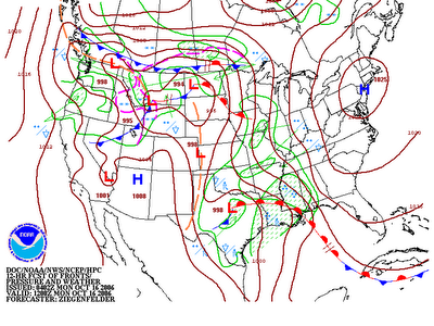
 Above is a weather map forecasting how this air mass will move within the next day and a half. Pay close attention to the red line with half-circles near the Gulf Coast. This is what is known as a warm front on all weather maps. This notation helps us determine where the warmer air is sitting. Keep in mind, the half-circles are in the direction that the warmer air is heading.
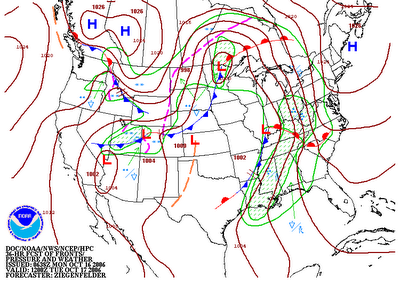
Along with a warm front comes the chance for some good soaking rains. This is certainly going to be the case with this system. By the time we see the sunshine on Wednesday rainfall totals could exceed an inch in many spots through Central and Eastern North Carolina and the Western part of our state may see closer to 2 inches of total rain.
No comments:
Post a Comment