
As I type this post, a snow advisory is in effect along the North Carolina-Tennessee border. The Smokey Mountains could see their first snowfall of the season. One to three inches of snow are possible late Sunday night and Monday morning in the higher elevations.
Elsewhere the big weather story this week in the state will be a coastal storm that could cause some problems as we get ready for the Thanksgiving holiday. This low pressure will develop off the South Carolina and Georgia coast Monday. The latest model data coming in this evening suggests this low may form closer to the coast than first indicated. This means more of an impact on our weather in the Triangle, the Sandhills, and possibly the Triad.
Here's a look at one computer model run by the State Climate Office of North Carolina for Tuesday night --
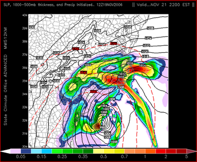
At this time, it appears rain will start spreading into our part of the state during the day Tuesday. With the low off our coast, our winds will come from the northeast keeping us cool and breezy. Afternoon temperatures will likely not make it out of the 40s on Tuesday.
The low will be slow to move away from the coast, so for now, rain is also in our forecast for Wednesday into early Thanksgiving. Wednesday will not be the best day for travel especially across the eastern half of the state. Rain, cool, and breezy conditions will not make for ideal travel conditions. Again on Wednesday, temperatures will likely only warm to the 40s.
The worst of the weather from this storm will come along our coastline, particularly along the Outer Banks where winds of 40mph or greater will be possible. Coastal flooding and erosion could be a problem.
Stay with News 14 Carolina this week for the latest developments on this coastal low. As always, we're the only place to turn for local weather updates every 10 minutes with Weather on the Ones.
No comments:
Post a Comment