
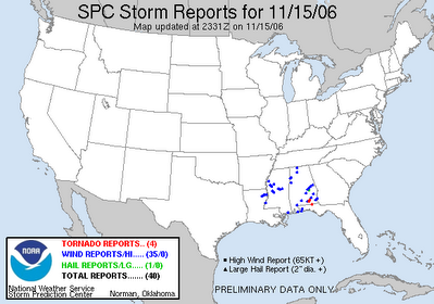
The above image is a map of storm reports from the Storms Prediction Center (www.spc.noaa.gov) as of Wednesday evening. the blue dots represent damaging wind reports and the red dots represent tornado reports.
We could see more reports of severe weather late tonight through tomorrow as this storm system moves toward the Carolinas.
Here in central North Carolina, strong to severe thunderstorms are a possibility Thursday morning into the midday hours. It appears the greatest threat will come from 4am through 3pm. Damaging winds and even a few isolated tornadoes will be a threat in the strongest storms.
At this point, we cannot say for certain that severe weather will happen Thursday. However, it is a possibility and now is the time to make sure you are prepared in the event that severe weather sweeps through the region.
We'll be here in the Weather on the Ones forecast center with the latest updates through the morning. Be sure to tune in for up to the minute weather information. If you experience severe weather in your neighborhood Thursday, let us know by e-mailing weather@news14.com
No comments:
Post a Comment