Friday, October 27, 2006

Fall Back This Weekend


Everyone gets an extra hour to enjoy the weekend! We fall back to standard time this weekend, so don't forget to set your clocks back an hour before going to bed Saturday night. Standard time officially begins at 2am Sunday morning. Enjoy that extra hour of sleep!

Rainy Friday

It is a rainy end to this work week across North Carolina. This was the scene along the beltline in Raleigh around midday --


And this was the scene around the Triad about the same time --

A well developed storm system, part of which produced blizzard conditions in Colorado, is making its move across the southeast. Doppler radar from midday showed widespread rain across the Carolinas, Georgia, and Alabama.

This will keep rain around central North Carolina tonight. In fact, the rain may pick up through the evening as the area of low pressure tracks closer to the state.

Most computer models agree that between one and two inches of rain are likely for our region from this storm. Some spots from the Triad to the west may see as much as three inches.

You can see the latest radar images by tuning into Weather on the Ones every 10 minutes on News 14 Carolina.

While we are starting the weekend on the soggy side, most of the weekend should be pleasant. The rain will finally come to an end early Saturday morning. With clearing through the day Saturday, we'll see a lot of sun in the afternoon.

Thursday, October 26, 2006

Rainy Weather for Friday

We are watching a developing storm system over parts of the country this Thursday. That system will eventually lead to a very wet Friday afternoon and night in central North Carolina.

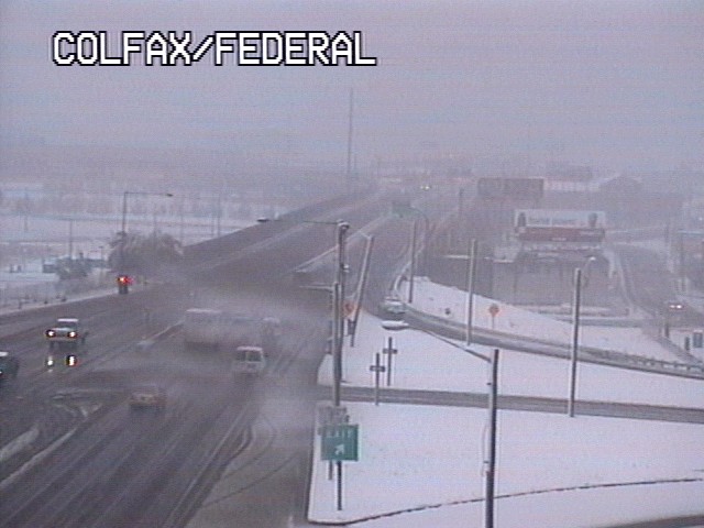
While we are enjoying cool temperatures and some sun today, part of that developing storm is producing heavy snow in Colorado where blizzard warnings are in effect for some locations.

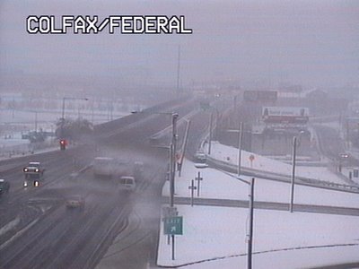
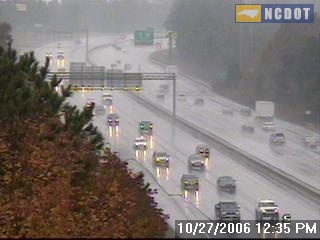
Take a look at a traffic camera today from Denver...

and another from Colorado Springs ...


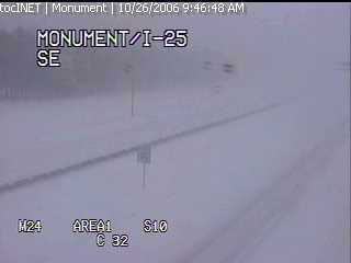
As of midday Thursday, the Denver airport had recorded about 4 inches of snow, but some spots in Colorado have reported well over a foot.

As the storm moves east late this afternoon, stormy weather is possible over the south central U.S. The Storms Prediction Center is watching an area from east Texas to Oklahoma to Louisiana for the possibility of severe storms today --

The storm system will continue to track to the east into the day Friday bringing us more clouds tonight and eventually a few showers in the morning. While we don't expect severe weather in our viewing area at this time, the rain could really pick up Friday afternoon and Friday night.


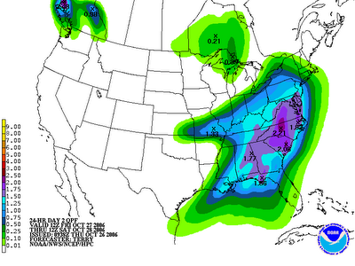
How much rain could we pick up from this storm? Many of us will likely see between one and two inches of rain. However, some spots especially around the Triad may see closer to three inches!

The bright spot in the forecast will come by midday Saturday through Sunday. The rain may continue into early Saturday morning, but it will move to our east bringing more sunshine our way by Saturday afternoon.

Wednesday, October 25, 2006

Another Cold Start

No doubt, many heaters across central North Caroline have gotten their first work out of the season the past couple of mornings. Many locations got at least close to the freezing mark this morning. A few early morning clouds prevented some spots from getting all the way to freezing. Here's a look at lows from around the region this Wednesday:
  • Southern Pines: 28
  • Lumberton: 30
  • Chapel Hill: 31
  • Asheboro: 32
  • Burlington: 32
  • Lexington: 32
  • Smithfield: 32
  • Greensboro: 33
  • Raleigh-Durham: 33
  • Mount Airy: 34
  • Goldsboro: 34
  • Fayetteville: 35
  • Louisburg: 36
  • Oxford-Henderson: 36
  • Winston-Salem: 36

While we were certainly cold this morning, it wasn't record cold. The records for this date are 27 for Raleigh and 28 for Greensboro, both set in 1962.

One other cold weather fact to note -- the earliest snowfall for Raleigh occurred on yesterday's date in 1887, 1903, and 1910. A trace of snow was reported each of those years.

Snow is not in our forecast anytime soon. However, Friday will likely be a cool and rainy day for the region. Stay tuned to Weather on the Ones for the latest!

Monday, October 23, 2006

Brighter, but Cooler...

Our local weather has changed significantly the last 24 hours. The up's and down's of Autumn are in full swing in North Carolina. In fact, yesterday and today are a perfect example of the changing seasons.

High temperatures throughout the area were held in-check to the upper 50's to near 60 on Sunday. The clouds and rain put a lid on allowing the thermometer to move upward. Now, if we'd had full sunshine, afternoon readings would have been at least ten degrees warmer!

While Sunday's airmass was relatively warm and moist- Monday's airmass is much cooler and drier. More a reminder that winter is on the way as a sunny sky has allowed for a beautiful day, but once you make your way outside it feels much different. Afternoon Monday has regional temperatures ranging from the mid to upper 50's. That's with more sunshine! Now, expect tonight and tomorrow night to be pretty chilly as widespread lower 30's will be common to Central and Eastern North Carolina.

On a side note, I wanted to mention a trip this past weekend to Atlanta for a close friends wedding. I drove this time around instead of taking to the air and found the fall colors shaping up not only in North Carolina, but all the way down to North Georgia! Beautiful reds, oranges, and golds are slowly reaching their peak in many spots along I-85. Sometimes it takes a nice long drive to make you appreciate the season. Seeing the color change certainly made the drive different, but somewhat splendid.

Sunday, October 22, 2006

Dreary Sunday

It was a dreary Sunday for the last day of the North Carolina State Fair, and it wasn't much different across most of central North Carolina. Light showers moved through during the day, but rain totals did not add up to much in most locations. The heaviest rains fell across the Sandhills.

Here's a look at rain totals from around the region:
  • Fayetteville: 0.42"
  • Goldsboro: 0.27"
  • Lumberton: 0.19"
  • Burlington: 0.17"
  • Chapel Hill: 0.17"
  • Oxford-Henderson: 0.17"
  • Raleigh-Durham: 0.16"
  • Greensboro: 0.12"
  • Erwin: 0.11"
  • Clayton: 0.10"
  • Rocky Mount-Wilson: 0.05"
  • Winston-Salem: 0.03"

The rain is moving out of the state this Sunday evening, we can look for clearing skies overnight. That will allow for a brighter start to the new week, but it will be cool for much of the week ahead. Highs will struggle to reach 60 on Monday, and we will likely stay in the mid 50s in most spots Tuesday.

The really cold temperatures will come during the early morning when lows will drop to the 30s for Tuesday and Wednesday morning. Patchy frost will be possible from the Triangle to the Triad both mornings.

Stay tuned to News 14 Carolina for your latest weather updates this week. We'll be along every 10 minutes with your Weather on the Ones forecast.

Saturday, October 21, 2006

Fall Colors

Driving around central North Carolina, we're beginning to see more and more of those fall colors showing up. One of my favorite places to see the fall colors is the mountains of North Carolina. Here's a picture taken Saturday afternoon from a web cam looking toward Cold Mountain in the Pisgah National Forest --
While there's nothing like seeing the splendid colors in person, if you're like me and can't make the trip to the mountains this year, you can see live views of the fall colors from your computer desktop. Check out www.highcountrywebcams.com for live views from around western North Carolina.

If you've visited the mountains this year and have some pictures of the fall foliage you'd like to share, e-mail them to us at weather@news14.com. We'll share some of them right here in our Weather on the Ones Blog.

For more pictures and information on the fall foliage around North Carolina, check out these links --

Friday, October 20, 2006

Last Weekend for the Fair

Thousands and thousands of folks have visited west Raleigh for the North Carolina State Fair this year. If you haven't been one of the thousands, there's still time to ride the rides and check out some of those deep fried goodies like fried Coca-Cola. While I tried to stay away from the deep fried foods this year, I have to recommend one of my favorite fair treats and that's the ice cream from North Carolina State's food science club. Even though it will be somewhat cool especially during the evenings, it won't be too cold to try out this treat!

So whether you like the ice cream, the turkey legs, the rides, or the exhibits at the fair, most of this weekend will feature great weather for the fair. Friday night will bring jacket weather with temperatures dropping into the 50s in the evening. Overnight lows will drop to mid 40s for early Saturday morning. Saturday afternoon will bring perfect weather for the fair -- sunny with highs in the upper 60s. Unfortunately, Sunday may not bring great fair weather as showers return to the forecast.

If you're visiting the fair this weekend, be sure to stop by the Time Warner Cable and News 14 Carolina booth just outside Dorton Arena. Chief Meteorologist Gary Stephenson will be there from noon until 3pm on Saturday, and you'll have the chance to meet our new weekend morning anchor Cassie Safrit from 5 until 8pm Sunday.

Thursday, October 19, 2006

Saharan Dust Could Affect Hurricanes


Think about this... tiny dust particles could have an effect on monster hurricanes. That's the latest word from researchers with the National Oceanic and Atmospheric Administration. Saharan dust clouds may limit hurricane activity in the Atlantic. Read more about how Saharan dust may impact our hurricane season through this link --

http://www.noaanews.noaa.gov/stories2006/s2719.htm

Wednesday, October 18, 2006

State Fair Fun...

I've had a blast meeting all the News 14 Carolina viewers that stopped by to see The Weather on the Ones team at the Time Warner Cable tent near Dorton Arena. I'm encouraged to learn that you tune to our channel to stay up to date on our always changing North Carolina weather. It's also good to know you trust us during severe weather situations. We're on every ten minutes each and every day and when the weather gets nasty we're not afraid to take control of the situation and go 'wall to wall'.

Okay, I'll step off the soap box now and get back to the subject. I've managed to get to the fair three times this year and I have not been let down! Why I even had my first giant turkey leg Wednesday. That was a sight to see, let me tell you. Here I am, all 5' 6" of me, carrying a turkey leg the size of a baseball bat along the Midway. Where else can you do that?!

So far my most memorable moment came last Friday when Jess Torpey and I stopped by the Agriculture tent to see the Stanley Cup. I've been waiting paitently for months to see the pride and joy of the NHL and the 2006 Champion Carolina Hurricanes. This amazing piece of history is just as breath taking in person as it is to see on television during the playoffs. Seeing it made me realize Lord Stanley's Cup has been more places on Earth than I have, or will ever see for that matter. What a moment, and one I won't soon forget.

Soggy Tuesday

We're getting a chance to dry out today after Tuesday's steady rainfall. Many locations from the Triad to the Triangle measured between 1 and 2 inches of rain. Here's a look at rain totals from around the region --

  • Chapel Hill: 1.67"
  • Asheboro: 1.67"
  • Goldsboro: 1.28"
  • Lexington: 1.16"
  • Greensboro: 1.11"
  • Burlington: 1.10"
  • Fayetteville: 1.06"
  • Raleigh-Durham: 0.99"
  • Winston-Salem: 0.98"
  • Rocky Mount-Wilson: 0.90"
  • Reidsville: 0.75"
  • Southern Pines: 0.65"
  • Lumberton: 0.19"

We'll see dry weather for the rest of this afternoon and for Thursday, but the rain may soon return. A cold front will cross the state Friday and that will likely bring a few showers and possibly a thunderstorm our way during the first half of the day Friday.

Tuesday, October 17, 2006

Carolina Quake...

Some residents near Winston-Salem had a small quake early this morning. The National Earthquake Information Center in Golden Colorado registered the shaker as a 2.6 on the Richter Scale. When compared to the 6.6 magnitue quake that jolted the big island of Hawaii over the weekend; this one was like a drop in the bucket. Most of the aftershocks in Hawaii have been larger than what rattled residents in Forsyth County.

If you are interested in seeing some info about this small quake feel free to check out the USGS site. A brief write up and more details can be found here.

Monday, October 16, 2006

A Look Back and Ahead

The opening weekend of the 2006 North Carolina State Fair was a major winner in the weather department as all the clouds and rain stayed away! I was out for the last public appearance of the Stanley Cup as were many Carolina Hurricane fans. We were not dissapointed as the cup was well worth the trip. However, I think many would argue that the food is the real reason for going to the State Fair. I mean where else can you tempt your taste buds with a fried oreo, fried twinkie, fried dough, fired coke, and fried whatever you can think of.

Away from the fun we did experience the coldest air of the season over the Carolinas. Sunday morning was a clear and crisp 33 at the RDU International Airport which broke a 27 year old record!

Right now skies are beginning to fill in with clouds and early Tuesday morning showers will breakout throughout the state and last pretty much all day long. This is all in concert with a milder air mass that's going to make for a nice Wednesday and Thursday, but to get there we have to experience some wet weather on Tuesday.

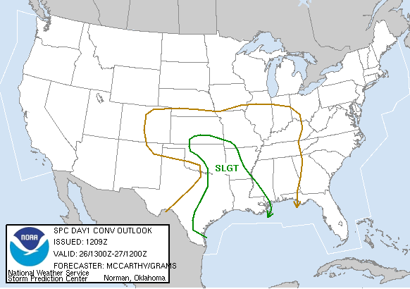
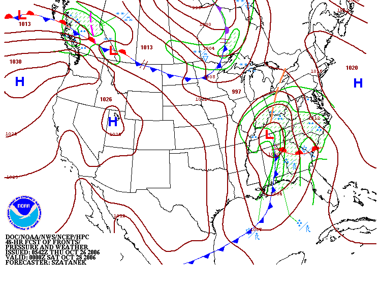
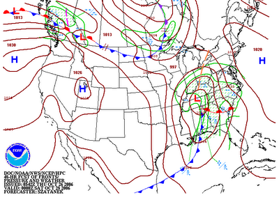
Above is a weather map forecasting how this air mass will move within the next day and a half. Pay close attention to the red line with half-circles near the Gulf Coast. This is what is known as a warm front on all weather maps. This notation helps us determine where the warmer air is sitting. Keep in mind, the half-circles are in the direction that the warmer air is heading.

Along with a warm front comes the chance for some good soaking rains. This is certainly going to be the case with this system. By the time we see the sunshine on Wednesday rainfall totals could exceed an inch in many spots through Central and Eastern North Carolina and the Western part of our state may see closer to 2 inches of total rain.

Sunday, October 15, 2006

Hawaii Earthquake

The big news from Sunday was a 6.6 magnitude earthquake reported just off the "Big Island" of Hawaii. Several aftershocks were felt after the initial quake. The above map from the U.S. Geological Survey shows the quakes measured Sunday around Hawaii.

Here are some links with more information on Sunday's quakes --

With news of the Hawaii earthquake, some may wonder about the possibility of an earthquake in North Carolina. While they are rare here, earthquakes can happen in our state. According to information from the USGS website, the strongest quake recorded in North Carolina took place near Waynesville on February 21, 1916. It was a magnitude 5.2 earthquake. There were reports of chimneys toppled and broken windows from the 1916 earthquake.

For more information on North Carolina earthquakes, check out these links --

Friday, October 13, 2006

October Snow!

Hey snow lovers... check this out --


No, it's not snow in North Carolina but record breaking snow has been falling over the Great Lakes region of the United States. The above picture was taken by the National Weather Service Office in Grand Rapids, Michigan.

Record breaking lake effect snow for October fell across portions of Michigan toward Buffalo, New York. In Buffalo, the National Weather Service says its the earliest lake effect snow recorded for the city.

No snow for us in North Carolina, but cold weather has arrived. Lows Friday night and Saturday morning will likely drop to the mid to upper 30s. It may be cold enough for some patchy frost in outlying areas around the Triad.

Read more about lake effect snow at these links --

Thursday, October 12, 2006

State Fair Time!


When the weather starts to turn cooler in North Carolina, it must be time for the State Fair! This year the fair starts on the exact day the cooler weather arrives. Friday's high temperature in Raleigh is expected to reach the low 60s for opening day at the fair. If you're headed to the fair Friday night, a jacket will definitely be in order as temperatures drop into the 40s. By early Saturday morning, lows should reach the mid to upper 30s!

As we mentioned a few days ago in our blog, News 14 Carolina will be at the fair each day. Visit us at the Time Warner Cable booth just outside the Dorton Arena. If you're planning on visiting the fair this year, you may find these links handy --

See you at the fair!

Wednesday, October 11, 2006

Winter Outlook


This week NOAA issued their outlook for the upcoming winter. It appears the winter will be influenced by El Nino. This would make for a milder than normal weather for much of the United States.

Based on the outlook, we can expect near normal winter temperatures and slightly above average precipitation in central North Carolina.

Keep in mind there is always an "uncertainty factor" when it comes to making long range forecasts. Just because the forecast calls for near normal temperatures, there could be a period of very cold weather and there could be a period of warmer than normal weather.

As for what many folks ask us.... any snow chances this winter? We'll just have to wait and see. On average, the Raleigh-Durham area records about 7 inches a year. Last winter no measurable snow was reported in the region.

You can read more about NOAA's winter outlook at this link --
http://www.noaanews.noaa.gov/stories2006/s2716.htm

Saturday, October 07, 2006

Fall Weather

Fall often brings changing weather to central North Carolina. We all know this fall is no different. This past Wednesday and Thursday temperatures reached the mid 80s. Today's temperatures in the Triangle struggled to reach 60.

There are more ups and downs to come over the next week. While the cool weather will continue for the rest of the weekend, look for a warm up early next week. Afternoon temperatures could be back to near 80 by Tuesday. Then a cold front will bring another big change by late week.

Of course there is more to fall in North Carolina than the changing weather. This is the time of the year for changing colors in our trees. The mountains of western North Carolina are always a popular destination in October to see these colors, and some of the fall colors are already being seen in the higher elevations of our mountains.

Here's a photo taken this week at Grandfather Mountain...

If you're planning a trip to see the fall colors, you may find these links helpful:
If you're traveling around the state and catch some of the vivid fall colors on your digital camera, we'd like to see them! We may even share a few here in our weather blog. Send us an e-mail anytime to weather@news14.com

And speaking of fall events, it's almost time for the....

The State Fair starts Friday! When you visit the fair this year, be sure to stop by the Time Warner Cable tent. You may just run into someone you know from News 14 Carolina.

Friday, October 06, 2006

Weather and a Chemical Fire

Earlier in the week, it appeared Friday would be somewhat of a quiet day in the Weather on the Ones Forecast Center. We would watch showers move through the area along with falling temperatures. However, explosions and a chemical fire at a facility in Apex changed that.

Through the early morning hours, our main focus attention became wind direction and speed along with the rain moving into the area. Would the rain help put out the fire or could it combine with the chemicals to create even more problems?

Through the day, we have been in close contact with the North Carolina Division of Air Quality and other emergency management officials. Air quality experts tell us that the rain seems to have helped in the situation. The rain diluted any chemicals that may have been emitted into the atmosphere. It also "washed away" particulate matter that could have been released by the explosions and fire.

Our news team continues to follow the latest developments from Apex. Stay with News 14 Carolina for the latest updates.

Wednesday, October 04, 2006

Big Changes Ahead

It certainly does not feel like fall this Wednesday in central North Carolina. Afternoon temperatures are running in the mid 80s in many spots. Some locations may even seen the upper 80s.

It is fall though, and these warm temperatures can't last forever. A cold front will bring big changes to the state over the next couple of days. As the front approaches Thursday, we will still be on the warm side of things with highs in the low to mid 80s. Look for showers and storms to move in with the front late Thursday afternoon and evening.

An area of low pressure along the front will be to our east Friday. That will bring northeasterly winds to our region, which will keep us very cool. Along with cloudy skies and a few showers, temperatures may struggle to reach the low 60s for Friday. The cool weather looks to last through at least Saturday with highs still in the low to mid 60s.

Afternoon highs in the 70s should return next week.

Sunday, October 01, 2006

Warm for the First of October

North Carolina had a warm start to October this Sunday. Here's a look at highs from around central North Carolina --
  • Fayetteville: 83
  • Smithfield: 82
  • Lumberton: 82
  • Goldsboro: 81
  • Asheboro: 81
  • Charlotte: 80
  • Raleigh: 79
  • Mount Airy: 79
  • Greensboro: 78
  • Winston-Salem: 78
  • Burlington: 78
  • Chapel Hill: 77

The next several afternoons may be even warmer than Sunday. Highs could climb as warm as the mid to upper 80s in the Triad and Triangle by Wednesday. Some locations in the Sandhills may even get close to 90.

Here are a few interesting stats to keep in mind through mid week.

Raleigh-Durham Airport

Monday --

  • Normal High: 76
  • Record High: 91

Tuesday --

  • Normal High: 76
  • Record High: 91

Wednesday --

  • Normal High: 75
  • Record High: 96

Piedmont Triad Airport (Greensboro)

Monday --

  • Normal High: 74
  • Record High: 91

Tuesday --

  • Normal High: 73
  • Record High: 91

Wednesday --

  • Normal High: 73
  • Record High: 94

A cold front should move across the state Thursday, bringing afternoon temperatures back to the 70s by the end of the week. Stay tuned to Weather on the Ones from News 14 Carolina for updates to the forecast.