
Most of our computer models suggest the Bermuda high will hold on strong through the weekend and next week. That means you want see many changes to our ongoing forecast. Afternoon highs will range from the low to mid 90s. With the humidity, the heat index, or "feels like" temperature will reach near 100 each afternoon.
Something else to note when talking about a Bermuda high is its influence on the path of tropical systems. A strong Bermuda high like the one impacting our weather this week can help to steer a tropical system toward the U.S. coastline. On the other hand, a weak Bermuda high can actually steer a tropical system out to sea keeping the east coast safe.
With that said, anytime we have a stronger Bermuda high, we have to keep a close on the tropics to see if there is any system developing for that high to steer our way. The National Hurricane Center said in its midday tropical update today that no tropical development is expected over the next couple of days, but there area couple of things to watch.
First, here's a satellite image from midday Thursday of the Caribbean --
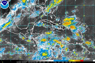
You'll notice a tropical wave has caused showers and storms to fire up just north of Puerto Rico and Hispanola. Conditions in the upper levels of the atmosphere over this wave are not favorable for tropical development at this time. However, a strong Bermuda high would tend to steer this feature closer to the U.S. coast, so it is something to watch over the coming days.
Something else to note is today's satellite image farther to the east, just off the African coast --
 You'll see another tropical wave that has recently moved off the cost of Africa. Now, there are no signs of development here either. However, these are signs that the tropics may be heating up. We've only had two named storms so far this hurricane season.
As we have mentioned here before, the peak of hurricane season does not arrive until late August and September. This Atlantic hurricane season still looks like it could be an active one. Perhaps, it will not be as active as last year, but it could become busy in the coming weeks. Stay tuned....
No comments:
Post a Comment