
Those same storms created some problems along the North Carolina coast this Sunday evening as well. The National Weather Service passed along several reports of funnel clouds and a tornado in Onslow County. I have not seen any confirmed damage reports at this point.
Saturday also proved to be an active weather night outside of our area as I mentioned in the previous blog post. Charlotte took a direct hit from a powerful thunderstorm around 9 to 11pm. Our colleague Matthew East was on the air in News 14 Carolina's Charlotte weather office keeping Charlotte viewers informed of the severe weather. While Matthew was on the air, our Charlotte offices took a direct lightning hit. For a period of time, some folks in the station thought the strike may have caused a fire. Luckily, the lightning strike had only tripped a fire alarm and there was no fire. I was watching some of the coverage from the Raleigh weather center at the time. Matthew stayed calm on the air still relaying critical information to Charlotte viewers. That's quite a task to do when there's severe weather outside and you're not sure if your building is on fire or not! Check out Matthew East's weather blog for his description of what happened. You'll find his blog at http://mattheweast.blogspot.com
Looking ahead to the new week, we should be in a typical summer weather pattern for North Carolina. It will be warm and humid with highs climbing toward the mid 90s by midweek. Each afternoon could bring a few isolated thunderstorms.
In the tropics, we'll be watching a disturbance in the western Gulf of Mexico. Here's a satellite image from the Gulf taken Sunday evening --
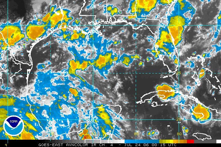 There is a disorganized area of showers and storms in the western Gulf of Mexico that have been drifting to the north. The National Hurricane Center (www.nhc.noaa.gov) says conditions could become favorable for the slow development of this system over the next day or so. They have scheduled a hurricane hunter aircraft to check this area out if needed Monday. We'll keep you posted on what happens. Check out our tropical update every hour at :21 after the hour.
In the meantime, enjoy your week!
No comments:
Post a Comment