
Raleigh: 95
Fayetteville: 95
Charlotte: 91
Greeneville: 97
Goldsboro: 95
Lumberton: 94
The tropics have started to gather steam as Tropical Depression Two formed Tuesday morning. The system itself formed along an old bounrdary that came through the Carolinas last weekend. T.D. #2 sits more than 200 miles to the south-southeast of Cape Hatteras with winds near the center of the storms at 35 mph. The National Hurricane Center has issued it's first forecast track on the depression.
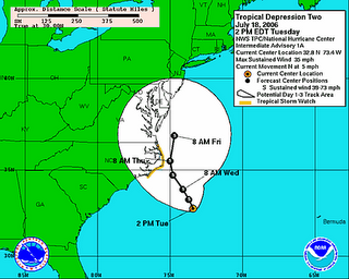
Keep in mind this is just a forecast track. The actual storm will not follow this path, but wobble around as it slowly moves northward and gradually gains strength. Some computer models want to move the system up then back it into the area of the North Carolina-Virginia border. Another one wants to push the storm back into Central North Carolina by late Thursday and Friday. Both of these are highly unlikely to pan out, but certainly something to follow.
No comments:
Post a Comment