
The trough that aided in the development of thunderstorms on Saturday is now a front located across the Atlantic off the Carolina coast. Two areas of low pressure have formed along the front. Here's a look at the satellite picture off the Atlantic from Sunday evening --
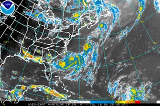
On occasion, when a low develops along a front over the Atlantic this time of year, a tropical system can form. Because of that, the National Hurricane Center is watching both lows for any signs that they may develop into a tropical depression. On Sunday evening, the first low was located about 290 miles south-southeast of Cape Cod, Massachusetts. This low was moving into cooler ocean waters, so tropical development is not anticipated. The second low pressure was located about 200 miles south of Cape Hatteras. In their tropical weather outlook this afternoon, the National Hurricane Center stated that slow development of this low is a possibility. At this point, that system should stay off shore, so even if it did develop into a tropical depression or storm, it would likely not cause many problems. When it comes to the tropics, things can change, so stay tuned....
Now our attention turns to a very hot week ahead for North Carolina. We will likely feel some of the hottest temperatures so far this season over the next couple of days. So far, the hottest afternoon highs have reached 95 in Raleigh-Durham on July 3 and June 22. In Fayetteville, the warmest high temperature of the year reached 98 on July 15. Highs in the mid to upper 90s are in our forecast for Monday. Afternoon temperatures may reach the upper 90s to near 100 on Tuesday and Wednesday. It will feel even hotter than that because of the humidity. Heat index values, or the "feels like" temperatures may reach near 105 the next several afternoons.
Find a cool place to stay this week! If you have any unique ideas on how to stay cool this summer, pass them along to me at lee.ringer@news14.com and I'll post some of them right here on our Weather on the Ones blog.
Have a great week!
No comments:
Post a Comment