
If you like hot weather, you are going to like the weather this week in central North Carolina. A ridge of high pressure in the upper levels of the atmoshpere will build into our region and that will really heat things up.
So far this summer, the warmest temperatures we have seen are 96 at the Raleigh-Durham Airport and 98 in Fayetteville. We may beat those readings by a couple of degrees or so on Tuesday and Wednesday. It will feel hotter than that all thanks to the humidity. The heat index, or the "feels like" temperatures could range between 105 and 110 Tuesday and Wednesday afternoons.
The National Weather Service office in Raleigh did an excellent job outlining the dangerous heat conditions we could experience this week. Here's a look at what they said in a special weather statement this afternoon --
235 PM EDT SUN JUL 30 2006
...NEAR RECORD HEAT EXPECTED THROUGH MUCH OF THIS WEEK...
A STRONG UPPER RIDGE OF HIGH PRESSURE WILL MOVE EAST... BRINGING HOT TEMPERATURES FROM THE MIDWEST INTO THE MID ATLANTIC. THIS HEAT WILL COMBINE WITH HIGH HUMIDITIES TO CREATE HEAT INDEX VALUES BETWEEN 100 TO 105 DEGREES MONDAY AND TUESDAY ACROSS CENTRAL NORTH CAROLINA. BY WEDNESDAY AFTERNOON HEAT INDEX VALUES OF 105 TO 110 ARE POSSIBLE... AND THIS HEAT WILL LIKELY CONTINUE INTO THURSDAY.
THIS PROLONGED HOT SPELL WITH INCREASING HEAT INDEX VALUES EVERYDAY THIS WEEK WILL POSE A SIGNIFICANT HEALTH RISK TO THOSE WORKING OR PLAYING OUTDOORS FOR EXTENDED PERIODS OF TIME. THOSE PLANNING ON WORKING OR PLAYING OUTDOORS THIS WEEK SHOULD PLAN ACCORDINGLY TO MINIMIZE HEAT EFFECTS FROM HEAT EXHAUSTION AND EVEN HEAT STROKE. THE MOST DANGEROUS DAYS FOR POSSIBLE EXTREME HEAT APPEAR TO BE LATE TUESDAY...WEDNESDAY AND THURSDAY. HEAT ADVISORIES AND EXCESSIVE HEAT WARNINGS MAY BE ISSUED LATER THIS WEEK.
HEAT INDEX VALUES FROM 105 TO 110 DEGREES DEGREES POSE HEALTH RISKS TO ANYONE WORKING OR PLAYING OUTDOORS AS WELL AS THE ELDERLY AND CHILDREN. HEAT CRAMPS...HEAT EXHAUSTION...AND DEHYDRATION ARE ALL POSSIBLE AT THESE HEAT INDEX VALUES...IF PROPER PRECAUTIONS ARE NOT TAKEN. HEAT INDEX VALUES OF 105 TO 110 POSE A THREAT TO ANYONE WORKING OR PLAYING OUTDOORS.
IN ADDITION TO THE HEAT...THE HIGH PRESSURE WILL RESULT IN A RATHER STAGNANT AIRMASS OVER THE REGION WHICH WILL LIKELY RESULT IN DETERIORATING AIR QUALITY. AIR QUALITY SHOULD DECLINE AS THE WEEK PROGRESSES AND THOSE SENSITIVE TO POOR AIR QUALITY WITH HEALTH CONCERNS ARE URGED TO MONITOR AIR QUALITY FORECASTS THROUGH THE WEEK.
HEAT SAFETY INFORMATION INCLUDING SAFETY PLANNING AND HEAT INDEXFORECASTS CAN BE FOUND ONLINE AT HTTP://WWW.ERH.NOAA.GOV/RAH/HEAT.
$$
JO
Sunday, July 30, 2006
Saturday, July 29, 2006
Weekend Weather Update
The weather stayed dry Saturday afternoon and evening in downtown Raleigh for the reopening of Fayetteville Street, but a few thunderstorms did pop up in other areas. At least one of those storms was on the strong side prompting several severe thunderstorm warnings. One storm downed a few small trees south of Garner near I-40 and the Wake County line. That same storm moved into Johnston County where it intensified. The National Weather Service passed on several reports of wind damage around Princeton in east central Johnston County.
As I write this blog post around 9pm Saturday evening, those storms are moving out of the News 14 Carolina viewing area. Most of us should stay partly cloudy and muggy for the overnight. A few isolated storms may fire up again Sunday afternoon.
Looking ahead to the new week, everyone will be talking about the heat and humidity. Afternoon highs will likely climb toward the mid to upper 90s on Monday and Tuesday. I wouldn't be too surpised if some neighborhoods especially in the Sandhills hit 100. It will certainly feel that way because of the humidity. Heat index values should range between 100 and 105 during the hottest part of the afternoon.
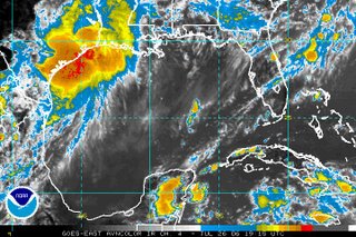
In the tropics this weekend, we've been keeping a close eye on two tropical waves, but neither are showings signs of development Saturday night.
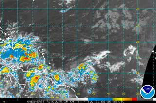 The first satellite pictures shows one of the tropical waves over the eastern Caribbean. Showers and thunderstorms seemed to pick up with this wave during the day Saturday. It does not appear that conditions are favorable for any further development of this system at this time. At least one computer model shows this disturbance drifting closer to the Gulf of Mexico by early next week, so it will still need to be watched.
As I write this blog post around 9pm Saturday evening, those storms are moving out of the News 14 Carolina viewing area. Most of us should stay partly cloudy and muggy for the overnight. A few isolated storms may fire up again Sunday afternoon.
Looking ahead to the new week, everyone will be talking about the heat and humidity. Afternoon highs will likely climb toward the mid to upper 90s on Monday and Tuesday. I wouldn't be too surpised if some neighborhoods especially in the Sandhills hit 100. It will certainly feel that way because of the humidity. Heat index values should range between 100 and 105 during the hottest part of the afternoon.
In the tropics this weekend, we've been keeping a close eye on two tropical waves, but neither are showings signs of development Saturday night.

 The first satellite pictures shows one of the tropical waves over the eastern Caribbean. Showers and thunderstorms seemed to pick up with this wave during the day Saturday. It does not appear that conditions are favorable for any further development of this system at this time. At least one computer model shows this disturbance drifting closer to the Gulf of Mexico by early next week, so it will still need to be watched.
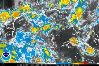
 The second satellite image shows the other tropical wave that we are keeping an eye on this weekend. This one does not appear as organized as it did Friday. Some slow development is still not out of the question for this system but does not appear likely at this time.
Friday, July 28, 2006
Watching the Tropics this Weekend
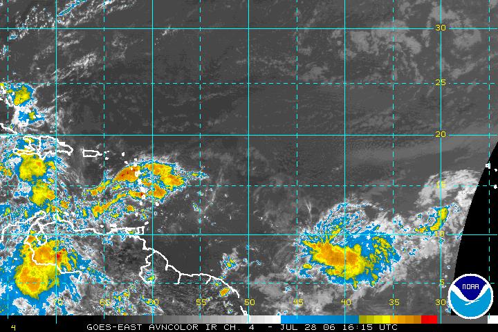
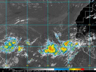
We are watching two tropical waves in the Atlantic basin as we head into the weekend. The satellite image above captured both of these waves from early Friday afternoon. The first wave on the left side of that satellite picture is making its way through the Caribbean. At this time, conditions are not favorable in the upper atmosphere for this tropical wave to develop into a tropical storm. There is just too much wind shear for this to develop.
That may be a different story for the other tropical wave we are watching. This one toward bottom right of the satellite image was located about 1000 miles west-southwest of the Cape Verde Islands. The disturbance appears to be fairly healthy today. Conditions in this area of the Atlantic may be favorable for slow development over the weekend. This one has the potential to become our next tropical depression within the next couple of days as it moves to the west or to the west-northwest. If it does develop into a tropical cyclone, it is a long ways from land, so there will be plenty of time to watch it. We'll keep you posted in our tropical updates at :21 past the hour on News 14 Carolina.
Thursday's Strong Storms
Thursday shaped up to be a very busy afternoon in the Weather on the Ones Forecast Center as strong to severe storms developed just after 1pm and moved across the region through around 7pm. Damaging winds and frequent lightning proved to be the biggest threat from the storms.
Here's a look at Thursday's severe weather reports from around the country provided by the Storm Prediction Center (www.spc.noaa.gov) --
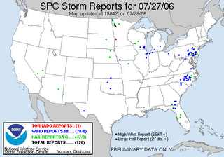 You'll notice the cluster of blue dots over central and eastern North Carolina. Those blue dots represent individual damaging wind reports. Here's a look at some of the local storm reports passed along by the National Weather Service:
- 1:55pm -- Trees down and house fires caused by lightning reported near Rolesville in Wake County.
- 2:30pm -- A trained spotter reported 60mph winds and pea size hail near Whispering Pines in Moore County
- 2:45pm -- Penny size hail reported by a Parks and Recreation Department employee near Louisburg in Franklin County
- 3:00pm -- Trees down reported near Fearrington in Chatham County
- 3:08pm -- Tree down reported near Warrenton in Warren County
- 3:30pm -- Trees down reported near Goldston in Chatham County
- 4:00pm -- Report of a tree down blocking traffic near Lake Boone Shopping Center in Raleigh. Other reports of large limbs down at Western Blvd. and Blue Ridge Rd.
- 4:10pm -- Reports of large tree limbs down near Kipling in Harnett County
- 4:15pm -- Reports of trees down along Hilltop-Needmore Road near Fuquay-Varina in Wake County
- 4:30pm -- Trees down reported near Coats in Harnett County
- 4:35pm -- Reports of trees down near Dunn in Harnett County
- 4:40pm -- Trees down near Vander in Cumberland County
- 5:15pm -- Trees reported down 8 miles east of Goldsboro in Wayne County near the Lenoir County line.
- 6:16pm -- 59mph wind gust recorded at Seymour Johnson Air Force Base near Goldsboro
- 6:25pm -- Tree reported on a house near Fremont in Wayne County
Friday is bringing us another hot and humid afternoon with highs in the mid 90s and heat index values reaching near 105. With the heat and humidity, a few storms may pop-up toward the late afternoon and evening hours. If they do, the storms could again be strong with gusty winds and frequent lightning. We'll keep you posted on News 14 Carolina.
Thursday, July 27, 2006
Bermuda High
There's one major weather feature that will be influencing our weather for the rest of the week and much of next week -- the Bermuda high. A high pressure often sets up shop this time of year in the northern Atlantic centered near the island of Bermuda, so we call it the "Bermuda high." Winds flow clockwise around a high pressure system, so a strong Bermuda high that ridges it way toward the U.S. east cost brings winds from the south and southeast into North Carolina. That keeps warm and humid air pumping into our region, and gives us that hot and humid weather that we are accustomed to in late July and early August. With the additional moisture around, we can't rule out a few pop-up thunderstorms with daytime heating.
Most of our computer models suggest the Bermuda high will hold on strong through the weekend and next week. That means you want see many changes to our ongoing forecast. Afternoon highs will range from the low to mid 90s. With the humidity, the heat index, or "feels like" temperature will reach near 100 each afternoon.
Something else to note when talking about a Bermuda high is its influence on the path of tropical systems. A strong Bermuda high like the one impacting our weather this week can help to steer a tropical system toward the U.S. coastline. On the other hand, a weak Bermuda high can actually steer a tropical system out to sea keeping the east coast safe.
With that said, anytime we have a stronger Bermuda high, we have to keep a close on the tropics to see if there is any system developing for that high to steer our way. The National Hurricane Center said in its midday tropical update today that no tropical development is expected over the next couple of days, but there area couple of things to watch.
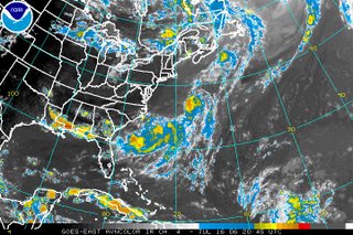
First, here's a satellite image from midday Thursday of the Caribbean --
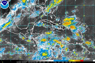
You'll notice a tropical wave has caused showers and storms to fire up just north of Puerto Rico and Hispanola. Conditions in the upper levels of the atmosphere over this wave are not favorable for tropical development at this time. However, a strong Bermuda high would tend to steer this feature closer to the U.S. coast, so it is something to watch over the coming days.
Something else to note is today's satellite image farther to the east, just off the African coast --
 You'll see another tropical wave that has recently moved off the cost of Africa. Now, there are no signs of development here either. However, these are signs that the tropics may be heating up. We've only had two named storms so far this hurricane season.
As we have mentioned here before, the peak of hurricane season does not arrive until late August and September. This Atlantic hurricane season still looks like it could be an active one. Perhaps, it will not be as active as last year, but it could become busy in the coming weeks. Stay tuned....
Most of our computer models suggest the Bermuda high will hold on strong through the weekend and next week. That means you want see many changes to our ongoing forecast. Afternoon highs will range from the low to mid 90s. With the humidity, the heat index, or "feels like" temperature will reach near 100 each afternoon.
Something else to note when talking about a Bermuda high is its influence on the path of tropical systems. A strong Bermuda high like the one impacting our weather this week can help to steer a tropical system toward the U.S. coastline. On the other hand, a weak Bermuda high can actually steer a tropical system out to sea keeping the east coast safe.
With that said, anytime we have a stronger Bermuda high, we have to keep a close on the tropics to see if there is any system developing for that high to steer our way. The National Hurricane Center said in its midday tropical update today that no tropical development is expected over the next couple of days, but there area couple of things to watch.
First, here's a satellite image from midday Thursday of the Caribbean --
You'll notice a tropical wave has caused showers and storms to fire up just north of Puerto Rico and Hispanola. Conditions in the upper levels of the atmosphere over this wave are not favorable for tropical development at this time. However, a strong Bermuda high would tend to steer this feature closer to the U.S. coast, so it is something to watch over the coming days.
Something else to note is today's satellite image farther to the east, just off the African coast --
 You'll see another tropical wave that has recently moved off the cost of Africa. Now, there are no signs of development here either. However, these are signs that the tropics may be heating up. We've only had two named storms so far this hurricane season.
As we have mentioned here before, the peak of hurricane season does not arrive until late August and September. This Atlantic hurricane season still looks like it could be an active one. Perhaps, it will not be as active as last year, but it could become busy in the coming weeks. Stay tuned....
Wednesday, July 26, 2006
Tropical Update
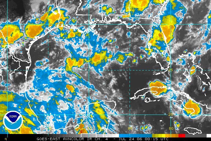
All is fairly quiet in the tropics this Wednesday. Over the last several days, we had been watching a disturbance in the western Gulf of Mexico. That system has moved inland as you see from this satellite image taken Wednesday afternoon.
The disturbance never became a tropical system, and since it is now inland it will not become a tropical system. However, it is spreading heavy rains across portions of Texas and Louisiana. This system will move toward the Tennesse Valley over the next day or so. Eventually, some of the moisture associated with the system will work its way into North Carolina and that could enhance our chances for afternoon showers and storms by the weekend.
Elsewhere, there is not much happening in the tropics. That is likely to change in the coming weeks. Tropical activity typically begins to pick up in the Atlantic toward August and September. We'll keep you posted.
Sunday, July 23, 2006
Weekend Recap; Looking Ahead to the New Week
Luckily, most of our viewing area missed out on any widespread severe weather this weekend. However, there were a few strong storms at times especially Sunday afternoon and evening. A severe thunderstorm warning was issued for Johnston County for a while as strong storms pounded areas from Smithfield to Selma to Princeton. There were a few reports of minor flooding. While that storm weakened somewhat, it still produced very heavy rain near Goldsboro where there were also some reports of minor flooding.
Those same storms created some problems along the North Carolina coast this Sunday evening as well. The National Weather Service passed along several reports of funnel clouds and a tornado in Onslow County. I have not seen any confirmed damage reports at this point.
Saturday also proved to be an active weather night outside of our area as I mentioned in the previous blog post. Charlotte took a direct hit from a powerful thunderstorm around 9 to 11pm. Our colleague Matthew East was on the air in News 14 Carolina's Charlotte weather office keeping Charlotte viewers informed of the severe weather. While Matthew was on the air, our Charlotte offices took a direct lightning hit. For a period of time, some folks in the station thought the strike may have caused a fire. Luckily, the lightning strike had only tripped a fire alarm and there was no fire. I was watching some of the coverage from the Raleigh weather center at the time. Matthew stayed calm on the air still relaying critical information to Charlotte viewers. That's quite a task to do when there's severe weather outside and you're not sure if your building is on fire or not! Check out Matthew East's weather blog for his description of what happened. You'll find his blog at http://mattheweast.blogspot.com
Looking ahead to the new week, we should be in a typical summer weather pattern for North Carolina. It will be warm and humid with highs climbing toward the mid 90s by midweek. Each afternoon could bring a few isolated thunderstorms.
In the tropics, we'll be watching a disturbance in the western Gulf of Mexico. Here's a satellite image from the Gulf taken Sunday evening --
 There is a disorganized area of showers and storms in the western Gulf of Mexico that have been drifting to the north. The National Hurricane Center (www.nhc.noaa.gov) says conditions could become favorable for the slow development of this system over the next day or so. They have scheduled a hurricane hunter aircraft to check this area out if needed Monday. We'll keep you posted on what happens. Check out our tropical update every hour at :21 after the hour.
In the meantime, enjoy your week!
Weekend Weather Update
Scattered strong thunderstorms developed Saturday evening across parts of North Carolina, but most of the Triangle and Sandhills missed out on the stronger storms. In fact, some parts of our area missed out on the rain all together. The strongest storms affected Charlotte and the Triad. The National Weather Service reported some minor flooding and trees down around Winston-Salem. Wind damage, hail, and intense lightning was also reported around Charlotte.
Some of the showers with a few embedded thunderstorms will continue across the News 14 Carolina viewing area through the early morning hours Sunday.
The showers and storms from Saturday formed ahead of a cold front moving toward the state. That front will be slow to move through North Carolina, so it is likely to be hanging around Sunday afternoon. That could be the focus for more storms from midday through the afternoon Sunday. Stay with News 14 Carolina for the latest on your weekend forecast.
Saturday, July 22, 2006
Will the Storms Develop?
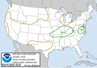
After scattered strong thunderstorms across the News 14 Carolina on Wednesday and Thursday afternoons, Friday was much quieter. As I write this blog post around 5pm Saturday, this have been quiet today so far... However, scattered thunderstorms could still develop across our region later this evening. The Storm Prediction Center (www.spc.noaa.gov) still has most of North Carolina under a "slight risk" for severe weather this evening.
 After mostly cloudy conditions for much of the day, skies have cleared some this afternoon. All that sunshine is heating things up and making the atmosphere over our area fairly unstable. Any storms that develop have the potential to become strong with gusty winds and frequent lightning.
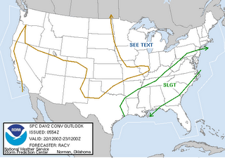
You'll notice that slight risk covers a large area from New England to the Gulf Coast. This region is the area just ahead of a cold front slowly pushes its way toward the east. At this point, there are numerous strong to severe storms rumbling across South Carolina. Those are mainly moving to the east. Again, there is still some potential for storms to fire up here in North Carolina. We're keeping a close eye on Doppler radar, and we'll have updates every 10 minutes on News 14 Carolina.
 After mostly cloudy conditions for much of the day, skies have cleared some this afternoon. All that sunshine is heating things up and making the atmosphere over our area fairly unstable. Any storms that develop have the potential to become strong with gusty winds and frequent lightning.
You'll notice that slight risk covers a large area from New England to the Gulf Coast. This region is the area just ahead of a cold front slowly pushes its way toward the east. At this point, there are numerous strong to severe storms rumbling across South Carolina. Those are mainly moving to the east. Again, there is still some potential for storms to fire up here in North Carolina. We're keeping a close eye on Doppler radar, and we'll have updates every 10 minutes on News 14 Carolina.
Friday, July 21, 2006
Storms for Friday Afternoon and the Weekend
Scattered strong to severe storms popped up across central North Carolina Wednesday and Thursday afternoons, and it appears more are on the way. As I write this blog during the noon hour Friday, our Stormtracker Doppler radar shows a quiet picture but that can change very quickly. The thunderstorms that formed the last two afternoons developed rapidly during the early afternoon and that is likely to be the case today.
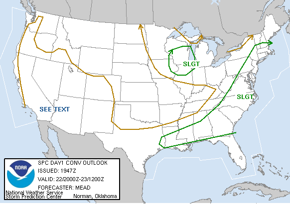
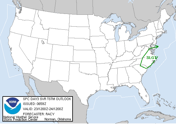
The Severe Storms Prediction Center (www.spc.noaa.gov) has placed portions of our state under a slight risk for severe weather for today.
The slight risk areas outlined for Friday on the map above are areas that the Storm Prediction Center are watching across the country for severe storms to pop-up. With our warm and humid atmosphere today, our biggest threat from thunderstorms will again be gusty winds, heavy rain, and frequent lightning.
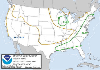
There are really no big changes coming up for the weekend, except the storms may be more numerous. A cold front will move toward North Carolina and that will serve as the focus for storms. We should start Saturday morning with some sun, which will warm temperatures into the upper 80s to near 90. That daytime heating will add instability to the atmosphere meaning storms that develop during the midday and afternoon hours will have plenty of energy to work with. Because of that, the Severe Storms Prediction Center again has our area under the slight risk for severe weather on Saturday --
And, the front that will bring showers and storms our way on Saturday will be slow to move through the state. As it hangs around for Sunday, we could again see more showers and storms. With a little sun possible Sunday morning, we may once again be looking at some showers and storms. Here's the severe weather risk map for Sunday --
The Severe Storms Prediction Center (www.spc.noaa.gov) has placed portions of our state under a slight risk for severe weather for today.
The slight risk areas outlined for Friday on the map above are areas that the Storm Prediction Center are watching across the country for severe storms to pop-up. With our warm and humid atmosphere today, our biggest threat from thunderstorms will again be gusty winds, heavy rain, and frequent lightning.
There are really no big changes coming up for the weekend, except the storms may be more numerous. A cold front will move toward North Carolina and that will serve as the focus for storms. We should start Saturday morning with some sun, which will warm temperatures into the upper 80s to near 90. That daytime heating will add instability to the atmosphere meaning storms that develop during the midday and afternoon hours will have plenty of energy to work with. Because of that, the Severe Storms Prediction Center again has our area under the slight risk for severe weather on Saturday --

And, the front that will bring showers and storms our way on Saturday will be slow to move through the state. As it hangs around for Sunday, we could again see more showers and storms. With a little sun possible Sunday morning, we may once again be looking at some showers and storms. Here's the severe weather risk map for Sunday --
It could be quite the active weekend in the Weather on the Ones Forecast Center. When you need an update on the latest conditions and the chance for storms, just switch over to News 14 Carolina. We're always here with weather updates every 10 minutes. In the event the storms get rough, we'll interrupt our regular programming and provide you with continuous severe weather coverage.
For you weather enthusiasts that often snap photos of developing storms or storm damage with your digital photos, we'd like to see your pictures! You can e-mail your weather photos and storm reports when its safe to do so to weather@news14.com. If you have questions about this weekend's forecast for stormy weather, feel free to ask them in the comment section below.
Thursday, July 20, 2006
Another Day with More Storms
It has been another fairly active weather day across parts of central North Carolina this Thursday. The strongest storms this afternoon were located over the Sandhills. We received a few reports of downed trees and some minor flooding around Fayetteville. Doppler radar estimates showed as much as 1 to 3 inches of rain fell over portions of Cumberland County.
We may see a repeat of Wednesday and Thursday for Friday. Quiet weather conditions are in the forecast through Friday morning. As afternoon highs soar toward the mid 90s, scattered thunderstorms could again develop. Some of those storms will have the potential to produce gusty winds, heavy rains, and frequent lightning.
The showers and storms will likely be more numerous for Saturday and Sunday as a cold front drops toward North Carolina for the weekend. Stay tuned to News 14 Carolina. We'll be here with updates every 10 minutes.
Wednesday, July 19, 2006
Strong Storms on Wednesday
 There's a look at Doppler radar from around 5pm Wednesday afternoon. Scattered strong storms have affected parts of the News 14 Carolina viewing area through much of the day. Here's a look at some of the storm damage reports passed along by the National Weather Service--
- 2:00pm -- Department of Highways reported trees down blocking roads in Stem and Cornwall in Granville County.
- 2:30pm -- Trees down on SR 56 near Butner in Granville County. Report from Granville County.
- 2:35pm -- Law enforcement reported a tree down blocking a roadway 4 miles northeast of Durham near the Durham-Wake County line.
- 3:00pm -- Law enforcement reported at New Hill Holleman Rd and Old US 1 near Apex in Wake County.
- 3:00pm -- Law enforcement reported trees down near Robbins in Moore County.
- 4:00pm -- Numerous trees down along US Highway 158 in Vance County. Report from law enforcement.
- 4:00pm -- Penny size hail reported by the public near Dabney in Vance County.
- 4:19pm -- The National Weather Service first relayed a report from fire and rescue officials of a roof possibly blown off a bank building near Anderson Creek in southern Harnett County. News 14 Carolina later spoke with Harnett County officials who said the roof had not been blown off, but damage was done to the roof. No injuries were reported.
- 4:28pm -- Nickel size hail reported by the general public near Littleton in Warren County.
- 4:30pm -- Law enforcement reported trees down near Spring Lake in Cumberland County.
If you have pictures of the storms or of storm damage, you can share them with us by e-mailing weather@news14.com On occasion, we post selected weather photos on our blog.
Beryl Bypass of NC
The second named storm of the season gathered enough steam yesterday morning at 11am for the National Hurricane Center to start formal monitoring. When the maximum sustained winds exceeded 36mph yesterday afternoon it was bestowed with the name "Beryl."
This is really a perfect storm for North Carolina... close but no cigar. Lurking roughly 100 miles east of Cape Hatteras this morning, this storm looks to continue moving to the north, then northeast, skirting coastal New England and potentially having a more significant impact on Nova Scotia and Newfoundland in Canada.
For now, we'll be watching for "Chris" in the Atlantic, hoping it is as harmless as "Beryl!"
Tuesday, July 18, 2006
From Hot Temps to Hot Trops...
Tuesday afternoon should be the hottest day of July and with the outside chance of a few stray days in August getting hot this should be the hottest day of 2006. Temperatures around the state from 3pm this afternoon:
Raleigh: 95
Fayetteville: 95
Charlotte: 91
Greeneville: 97
Goldsboro: 95
Lumberton: 94
The tropics have started to gather steam as Tropical Depression Two formed Tuesday morning. The system itself formed along an old bounrdary that came through the Carolinas last weekend. T.D. #2 sits more than 200 miles to the south-southeast of Cape Hatteras with winds near the center of the storms at 35 mph. The National Hurricane Center has issued it's first forecast track on the depression.
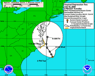
Keep in mind this is just a forecast track. The actual storm will not follow this path, but wobble around as it slowly moves northward and gradually gains strength. Some computer models want to move the system up then back it into the area of the North Carolina-Virginia border. Another one wants to push the storm back into Central North Carolina by late Thursday and Friday. Both of these are highly unlikely to pan out, but certainly something to follow.
Raleigh: 95
Fayetteville: 95
Charlotte: 91
Greeneville: 97
Goldsboro: 95
Lumberton: 94
The tropics have started to gather steam as Tropical Depression Two formed Tuesday morning. The system itself formed along an old bounrdary that came through the Carolinas last weekend. T.D. #2 sits more than 200 miles to the south-southeast of Cape Hatteras with winds near the center of the storms at 35 mph. The National Hurricane Center has issued it's first forecast track on the depression.
Keep in mind this is just a forecast track. The actual storm will not follow this path, but wobble around as it slowly moves northward and gradually gains strength. Some computer models want to move the system up then back it into the area of the North Carolina-Virginia border. Another one wants to push the storm back into Central North Carolina by late Thursday and Friday. Both of these are highly unlikely to pan out, but certainly something to follow.
Monday, July 17, 2006
Ice Cream and A/C
Both of which are going to help you beat the heat for the next week. Tuesday and Wednesday should be the hottest days we'll feel this year. A great deal of sunshine will send the thermometer soaring to at least the upper 90's with some isolated spots touching 100. We'll have to factor in the humidity as well and that'll push the heat index to at least 103-106.
All of the hot weather is well above average for July, but Mother Nature is right on cue as the third week in July is typically the hottest period of time in the United States. What's setting this year apart is the huge area of the country that's having temps at-or-above 100. One example is Pierre, South Dakota when 117 was recorded on Saturday, July 15.
Some things to watch this week will be the record high temps and how close we come to breaking them... Here are the RDU records for the next three days.
Tuesday, July 18: 99 (1986)
Wednesday, July 19: 99 (1986)
Thuesday, July 20: 100 (1977)
Sunday, July 16, 2006
Saturday's Storms, an Update on the Tropics, and Looking Ahead to a Hot Week
Saturday was a fairly busy day in the Weather on the Ones Forecast Center. We did not have any widespread severe weather, but a few isolated storms became rather strong at times. There were some spotty reports of wind damage from some of the strongest storms. A News 14 Carolina viewer in southern Cumberland County reported several large trees down in his yard along Matt Hair Road in the Cedar Creek community. The National Weather Service also passed along reports of trees down in this same area of Cumberland County. Outside of Cumberland County, we had reports of pea size hail near Dunn in Harnett County and trees down in the Anderson Creek area of Harnett County.
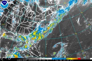
The trough that aided in the development of thunderstorms on Saturday is now a front located across the Atlantic off the Carolina coast. Two areas of low pressure have formed along the front. Here's a look at the satellite picture off the Atlantic from Sunday evening --
The trough that aided in the development of thunderstorms on Saturday is now a front located across the Atlantic off the Carolina coast. Two areas of low pressure have formed along the front. Here's a look at the satellite picture off the Atlantic from Sunday evening --
On occasion, when a low develops along a front over the Atlantic this time of year, a tropical system can form. Because of that, the National Hurricane Center is watching both lows for any signs that they may develop into a tropical depression. On Sunday evening, the first low was located about 290 miles south-southeast of Cape Cod, Massachusetts. This low was moving into cooler ocean waters, so tropical development is not anticipated. The second low pressure was located about 200 miles south of Cape Hatteras. In their tropical weather outlook this afternoon, the National Hurricane Center stated that slow development of this low is a possibility. At this point, that system should stay off shore, so even if it did develop into a tropical depression or storm, it would likely not cause many problems. When it comes to the tropics, things can change, so stay tuned....
Now our attention turns to a very hot week ahead for North Carolina. We will likely feel some of the hottest temperatures so far this season over the next couple of days. So far, the hottest afternoon highs have reached 95 in Raleigh-Durham on July 3 and June 22. In Fayetteville, the warmest high temperature of the year reached 98 on July 15. Highs in the mid to upper 90s are in our forecast for Monday. Afternoon temperatures may reach the upper 90s to near 100 on Tuesday and Wednesday. It will feel even hotter than that because of the humidity. Heat index values, or the "feels like" temperatures may reach near 105 the next several afternoons.
Find a cool place to stay this week! If you have any unique ideas on how to stay cool this summer, pass them along to me at lee.ringer@news14.com and I'll post some of them right here on our Weather on the Ones blog.
Have a great week!
Friday, July 14, 2006
Afternoon/Evening Thunderstorms
A few strong thunderstorms rumbled across parts of our region Thursday evening. The strongest storms affected areas mainly north of Raleigh. The National Weather Service passed along reports of downed trees in Warren and Franklin Counties in the News 14 Carolina viewing area. Flooding was even reported along Duke Street and Durham.
We could see another round of thunderstorms this Friday afternoon and evening. The storms should be scattered, so not everyone will see the rain. However, the strongest storms could again produce heavy downpours, frequent lightning, and gusty winds. We'll be keeping a close eye on Doppler radar through the afternoon and evening. As always, you can find the latest weather updates on News 14 Carolina every 10 minutes. No need to wait until the evening news at 5, 6, 10, or 11 tonight!
If storms move through your area and it's safe do so, we'd like to see any storm photos you may have to share. Send your weather photos to weather@news14.com anytime. We'll share some of them right here on our weather blog.
Thursday, July 13, 2006
Tropical Action in the Pacific
 The Atlantic hurricane season has been fairly quiet with only one named storm so far. There are no signs of tropical development in the Atlantic basin over the next few days, but that is a different story in the Pacific. The above satellite image from midday Thursday shows two hurricanes -- Hurricane Bud and Hurricane Carlotta.
As I write this blog midday Thursday along the east coast, Bud is the strongest of the two storms with maximum sustained winds around 115mph. That makes Bud a category 3 hurricane. Fortunately, both storms are located over the open waters of the Pacific and are not forecasted to affect land over the next 3 to 5 days.
You can find more on these storms including the latest forecast tracks by clicking to the National Hurricane Center's website at http://www.nhc.noaa.gov/
By the way, even though the Atlantic hurricane season seems to have been quiet so far, don't let that fool you. We typically do not see many storms in June and July, and the season will likely begin to pick up through August and September. Stay tuned...
Wednesday, July 12, 2006
Hot and Humid
Looking for relief from the heat and humidity? You'll have to travel far away from North Carolina this week. It looks like the summer weather will continue for the next several days with highs in the low to mid 90s. When you factor in the humidity it feels closer to 100 in the heat of the afternoon.
Of course, it's not hot everywhere. If you're looking to really cool off, check out the current conditions at the South Pole by clicking the following link --
http://weather.noaa.gov/weather/current/NZSP.html
Of course, it's not hot everywhere. If you're looking to really cool off, check out the current conditions at the South Pole by clicking the following link --
http://weather.noaa.gov/weather/current/NZSP.html
Saturday, July 08, 2006
World Champs in the Triangle
 Since the weather is tranquil this weekend, I thought I would take a break from talking about the weather to tell you about a group of world champions that live right here in the Triangle. No, I'm not talking about the Carolina Hurricanes. I'm actually talking about a small group of computer engineering students from North Carolina State University in Raleigh. The image you see on the left is a screen capture from a program this group of students designed to model UV ray exposure to 3-D objects including the human body. Their program placed first in the IEEE Computer Society International Design Competition topping other universities from around the country and around the world.
You probably hear us talk about the UV index each day in our Weather on the Ones forecast. When the UV index is high, you have a greater chance to get a sunburn when spending time outdoors without a sunblock lotion. This is important information because studies have shown sunburns could lead to skin cancer later in life. This computer program designed by NC State students called SunRay can model what parts of the body could be especially susceptible to UV rays during different times of the day and at different locations around the world.
Before the students presented their program at the competition in Washington, DC, I had the opportunity to meet a couple of the team members to discuss how meteorologists and the general public may be able to use information provided by their program. It was a pleasure meeting the team and their professors. I can tell you this team certainly deserved this honor. Isn't it great to hear about world class students doing great things right here at home in North Carolina?
You can meet the team and read more about their program through this link --
http://www.csc.ncsu.edu/news/news_item.php?id=378
Friday, July 07, 2006
Great Weekend Weather!
I hope you are able to spend at least a little time outdoors this Friday afternoon. Humidity levels are lower than what we typically experience this time of year in North Carolina. Combine that with cooler than normal temperatures, and it makes for almost perfect weather conditions for a July afternoon. Dewpoints, a measure of the humidity, are in the upper 50s to low 60s today. When dewpoints reach the upper 60s to near 70, the humidity makes it feel sticky outside, so this is welcomed relief.
It is also a much brighter day today. If you are reading this from your cubicle at work with no window in sight, here's a view for comparison --
It is also a much brighter day today. If you are reading this from your cubicle at work with no window in sight, here's a view for comparison --

If you are thinking this is July and these comfortable summer conditions can't last forever, you are correct. We do expect nice weather through the weekend, but the heat and humidity will begin to increase by late in the weekend and early next week. Highs on Saturday in the News 14 Carolina viewing area should reach the mid 80s. We'll see the upper 80s Sunday, and we'll be back in the low 90s by Monday.
When making a forecast, a meteorologist always has to think -- is there anything that could happen that could make my forecast incorrect? Right now, it appears unlikely that something could change this weekend, but we will be watching the front that moved through the state on Thursday. That front would not move back toward North Carolina, but there have been occasions when a tropical system spins up along a frontal boundary across warm ocean waters. Here's a look at the satellite picture from midday Friday --
There are no signs of a tropical system developing along that front. However, at least one of the computer models I looked at while forecasting this morning hinted at a low developing along the front and spreading rain into North Carolina late in the weekend. Latest runs of that model this midday have backed off on that solution. Other models do not show the low developing. Because of that, we will stay with our forecast for pleasant weekend weather and just keep a close eye on that front for any changes. As you enjoy the nice weekend weather, check back with Weather on the Ones on News 14 Carolina in the event there are any changes to the current forecast. We always have our latest tropical outlook at :21 after the hour.
Thursday, July 06, 2006
Improving Weather on the Way
It has been a soggy and sometimes dreary day across central North Carolina. Here's a look from one of the DOT cameras in Durham from the lunch hour Thursday --
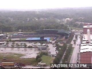

That picture of the Durham Bulls Athletic Park should look much better for Friday and the weekend!
Today's showers and thunderstorms are the result of a cold front passing through the state. As the front passes to the south and southeast, the rain should come to an end through the late afternoon and evening. Behind the cold front, slightly cooler and drier air will filter into the state. That means the heat and humidity from early this week will take a break, for at least a few days. Friday's highs are forecasted to reach the mid 80s, but with the lower humidity it will feel very comfortable.
The lower heat and humidity won't last forever though. It is July after all! Computer models are suggesting a return to typical summer weather conditions in North Carolina, and I don't see any reason why that forecast will not hold. Highs will climb back to the low to mid 90s next week with that chance for a few pop-up storms in the afternoons. So, enjoy the comfortable weather while it lasts!
Monday, July 03, 2006
The Three H's Have Returned!
Hazy, Hot and Humid- All three go hand in hand, in hand with summer time. Now that the calendar has flipped to July, Mother Nature is right on cue and packing heat. Monday and Tuesday are shaping up to be the hottest days so far in 2006 for Central and Eastern North Carolina.
Let's put things in perspective: At 1pm, Monday afternoon some area temperatures were as follows...
Raleigh: 92
Fayetteville: 91
Wilson: 91
Charlotte: 90
It gets worse. We also have to take into account the thick, humid airmass over the Carolinas to come up with the heat index! So to our skin the afternoon heat feels more like...
Raleigh: 97
Fayetteville: 97
Wilson: 97
Charlotte: 92
Just remember to take it easy today and the 4th. Water is the best thing to fight the summer heat, but you can also use these tips to stay cool.
* Drink plenty of water to stay hydrated. Avoid alcohol as mixed drinks and beer will cause you to dehydrate faster.
* Wear light colored, light weight clothing. I prefer a soccer jersey, athletic shirt or something that'll allow air flow and rapid drying of moisture. The lighter colors help to reflect the intense heat- thus keeping you cool.
* Try to avoid outdoor work until the early morning or evening hours. The direct rays of the sun cause our temperatures to reach their peak from 2-5pm. If you can wait it out you'll feel much more comfortable and probably get more work done.
Sunday, July 02, 2006
Space Shuttle and Weather
 NASA delayed the launch of Space Shuttle Discovery again today due to the weather. Scattered thunderstorms played havoc on the planned launch. As you may expect, NASA has strict guidelines concerning what kind of weather conditions under which a shuttle can launch. I searched around on NASA's website and found detailed guidelines from 1995. Here's the link --
http://www-pao.ksc.nasa.gov/kscpao/release/1995/122-95.htm
Discovery's launch is now scheduled for Tuesday, July 4 at 2:38pm. Let's hope the weather cooperates. Wouldn't it be cool for the U.S. to launch back into space on Independence Day? As of Sunday evening, the National Weather Service forecast calls for 40% chance for thunderstorms for Tuesday. Let's keep our fingers crossed...
If you are interested in reading more about the shuttle launch, you may find these links interesting --
- Full Discovery Coverage from nasa.gov
- Cape Canaveral, FL Forecast
- Current Weather Conditions at Launch Facility
While astronauts will be keeping watch on the chance for afternoon storms in Florida, we could see a few pop-up storms here in central North Carolina the next several afternoons. There were a couple of these isolated storms over Hoke and Cumberland Counties this Sunday afternoon, while the rest of the News 14 Carolina viewing area stayed hot and dry. We will likely see a similar scenario Monday and Tuesday afternoons when any storms that develop will be isolated. Afternoon storms may be more numerous by Wednesday and Thursday.
As we get closer to the 4th of July, it certainly feels like summer. Temperatures topped out around 94 today in the Triangle today. Monday afternoon highs may be a couple of degrees warmer. It will feel warmer with the humidity. Heat index values will soar to near 100 during the hottest part of the afternoon.
In other weather news, the tropics are fairly quiet for this second day of July. However, we are watching a trough of low pressure over the Gulf of Mexico. Take a look at this satellite picture from Sunday evening --

Showers and storms have developed from that trough of low pressure over the Gulf off the Texas coast. Conditions are not favorable for tropical development tonight, but we'll have to keep a close eye on this area. Even if it does not become a tropical system, this disturbance will likely bring heavy rains to the Texas coast over the next couple of days.
Saturday, July 01, 2006
Hot Weekend Weather
Hot weather is in the forecast through the 4th of July. Afternoon highs the next few days will likely be slightly warmer than what we saw this Saturday. Today's high reached 88 at the Raleigh-Durham Airport, which is right at the "normal" reading for this time of the year. Luckily, it wasn't as hot as it was just one year ago when we tied the record high of 99 for July 1. Other afternoon highs from around the region include 90 in Fayetteville and in Lumberton.
We are forecasting highs in the mid 90s for Sunday through Tuesday. At least one of the computer models we use to forecast weather is suggesting highs as hot as 98 by Monday, which should be the warmest day of the next week.
The chance for even an isolated shower looks slim for Sunday, but we could see one or two isolated showers or thunderstorms Monday and Tuesday afternoons. We do anticipate more widespread shower and thunderstorms for Wednesday and Thursday afternoons.
In the tropics, all is quiet. The National Hurricane Center does not anticpate in any tropical development over the next day or two.
Enjoy the rest of your weekend and prepare for the hot weather and plenty of sunshine! When you need an update on your 4th of July forecast, remember you don't have to wait for an evening newscast at 5, 6, or 11. Your forecast is never more than 10 minutes away with Weather on the Ones only on News 14 Carolina!
Subscribe to:
Posts (Atom)