
To judge the "comfort factor," we rely on dewpoint. When dewpoints are in the upper 60s to low 70s, it becomes very uncomfortable outside. These are the levels we think of on a hot and humid summer day. Dewpoints were in this range from Fayetteville to Goldsboro this afternoon. However, in the Raleigh-Durham area, dewpoints were in the upper 50s to near 60 for a good part of the day. Those lower readings are somewhat unusual for this time of year, and they won't last much longer. The humidity will begin to increase over the next couple of days.
You can read more about dewpoint here --
On to another topic now -- the tropics. We continue to monitor a disturbance off the southeast coast.
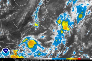
The system drifted to the southwest today and is located off the Georgia coast as of this blog post. There is still a very small chance this could become a tropical depression, but time is running out for the disturbance. Upper level winds will not be favorable for development Friday. We'll have more on the tropics at :21 after the hour and you can also find the latest online at www.nhc.noaa.gov
No comments:
Post a Comment