
 Ernesto had strengthened into a hurricane Sunday morning but then weakened back to a tropical storm Sunday afternoon. The storm brushed past the south and southwestern coast of Haiti.
The country of Haiti is fairly mountainous, and the frictional effects of a hurricane interacting with a mountainous land area often weakens a hurricane. As the storm pulls away from Haiti Sunday night, there is some potential for it to strengthen back to a hurricane, but it may not stay that way long. It will likely move across Cuba Monday and weaken some. Once it hits the warm ocean waters again, a strengthening phase could begin again. The bottom line -- look for changes in the intensity over the coming days.
The next question is where does the storm go once it moves past Cuba. The Florida Keys could be the next target. There are reports that tourists were asked to leave the Keys Sunday afternoon. That's not such a bad idea since there is only one way out of the Keys, and that part of Florida is often evacuated well ahead of a storm.
The Gulf coast of Florida could be Ernesto's next stop, but it is important to note that the storm could be anywhere in the shaded area on the above forecast track. That means even the east coast of Florida is not totally out of danger just yet.
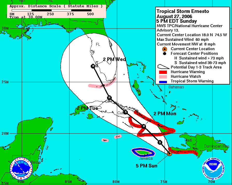
The uncertainty in a tropical cyclone forecast grows after 3 days, but since it can take several days to make preparations for a hurricane, the National Hurricane Season has issued 5 day forecasts for the past few seasons. Take a look at the 5-day forecast from the 5pm NHC advisory --

You will note the forecast track takes Ernesto along the east coast including the Carolinas after it crosses Florida. If Ernesto does follow this path, it could have a big impact on our weather by late in the week or the weekend. However, the storm could be anywhere in the shaded area. If the storm takes a more easterly track out to sea, we would feel very little impact here in central North Carolina.
Some computer models are indicating a very interesting weather pattern for us by late in the week. It appears cooler air could settle into North Carolina and dam up against the mountains. This is a weather pattern that we see more often in the winter, but it does occur on occasion in the summer. If this does set up, it would keep us cloudy with some rain and daytime temperatures only in the 70s. This coupled with Ernesto could bring a lot of rain to the region.
Rainfall may not be such a bad thing for North Carolina though. As we mentioned late last week, moderate drought conditions have returned from the Triangle to the north. We just don't need the flooding rains that we experienced when the remnants of Tropical Storm Alberto moved through.
At this point, we cannot say for certain if Ernesto will impact North Carolina, but it is a possibility. It will be a busy week in the Weather on the Ones forecast center as we closely monitor the storm. We'll be sure to pass along the very latest information as we get it in our Weather on the Ones forecasts, so stay tuned...
If you'd like to track Ernesto and find out more information about the storm early this week, you may find these links helpful --
No comments:
Post a Comment