
Ernesto could bring problems our way late Thursday into Friday. Here's the forecast track from the 5pm Wednesday evening advisory --
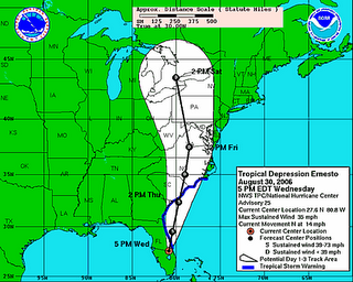
Ahead of Ernesto look for heavy rains to spread into central North Carolina Thursday afternoon and evening. Those heavy rains will likely continue through Friday morning. Three to five inches of rain can be expected, but higher amounts are possible especially since Ernesto will be interacting with a stalled front. Isolated tornadoes could pose another threat just along the storm's track and to the right of the track.
For the very latest on Ernesto, tune to News 14 Carolina. We're your only local source for weather updates every 10 minutes.
No comments:
Post a Comment