
 I was surfing around the internet today and found an interesting article from NOAA on the hurricane season. It touches on a lot of points I made in my hurricane season post yesterday. The article also points out hurricane preparedness information and a few hurricane misconceptions. You can check it out at this link -- http://www.magazine.noaa.gov/stories/mag205.htm
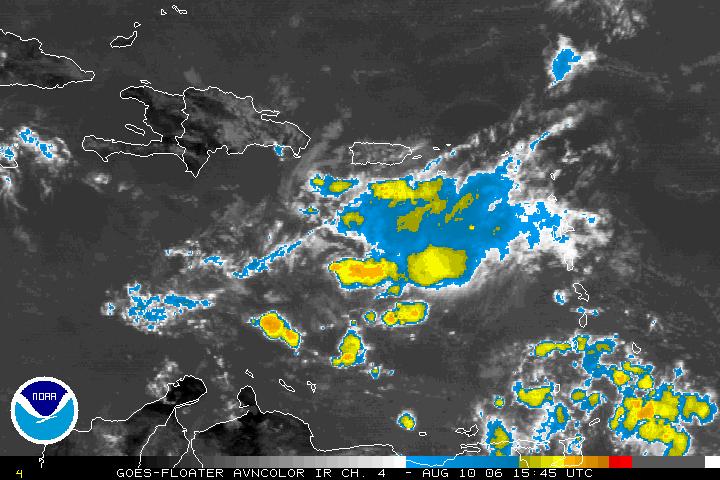 In the tropics this Thursday, we are still watching the tropical wave that was just east of the Windward Islands yesterday. Today that wave is in the eastern Caribbean but does not look as organized as it did around this time yesterday. The National Hurricane Center did send a hurricane hunter airplane into the system yesterday, but they did not find a closed center of circulation. Another plane was scheduled for today, but they have cancelled that mission as the system is not very well organized. The NHC said in its midday update that conditions are not favorable for development of this wave over the next couple of days. Elsewhere, the tropics are quiet for now.
Now our attention turns to the forecast for the rest of the week and the weekend. Scattered thunderstorms should develop this afternoon and tomorrow afternoon. With daytime heating today, one or two of those storms may get a little strong with heavy downpours and gusty winds. However, not everyone will see the rain today.
The forecast for Saturday is looking a little more uncertain. A couple of the computer models that we use to forecast weather are suggesting Saturday could shape up to be a cloudy, cooler, and wet day. Here's a look at the output from the NAM model for around midday on Saturday.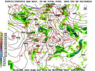
This model almost suggests something that we call a "wedge" setting up in North Carolina. You may recall meteorologists talking about this pattern more in the winter months. High pressure in the northeast brings winds from the northeast into the area. That brings in cooler air into the state that wedges up against the mountains. That would also keep cloudy skies and at least light rain showers in the area through the day. If this pattern does pan out, temperatures on Saturday may not get much warmer than the 70s! One of the latest models out around midday today is forecasting a high of 67 for Raleigh on Saturday. Not bad for August in North Carolina when our highs are typically in the upper 80s. If the clouds don't hang on and we see some sun, temperatures would warm into the 80s.
As I mentioned, there is still some uncertainty in the forecast for Saturday, so you'll probably notice some changes in the forecast over the next day. We'll keep you posted with the latest forecast on news14.com and every 10 minutes with Weather on the Ones on News 14 Carolina.
No comments:
Post a Comment