
An area of low pressure is forming east of the Florida coast near the Bahamas. This is located along an old cold front that moved through North Carolina this past weekend. The disturbance is encountering some dry air as I write this blog post Monday night, but conditions may become favorable for tropical development over the next day or two. The National Hurricane Center has scheduled an aircraft to check out this area Tuesday if necessary. The disturbance is nearly stationary right now but may slowly drift to the north over the next couple of days. There is uncertainty to whether this system will develop or not and to what direction it may move. We'll keep you posted...
The other system we are watching is much farther away...
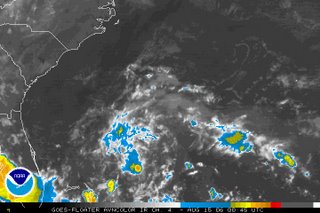
 That is the satellite picture from Monday night off the African coast. An area of thunderstorms moved off the coast today moving toward the Cape Verde Islands. There is some potential this could also slowly develop over the next couple of days.
For the very latest on the tropics, you can always tune in to our tropical update at :21 after the hour on News 14 Carolina or visit the National Hurricane Center's website at www.nhc.noaa.gov
No comments:
Post a Comment