
Let's start with the heat... Today's afternoon temperatures topped out at 97 at the Raleigh-Durham Airport and 99 at the Fayetteville Regional Airport. I saw our thermometer at News 14 Carolina reach 102 this afternoon before a small isolated thunderstorm briefly cooled things down in north Raleigh. Our high here off of Atlantic Avenue was higher than the high at the airport likely due to the fact that we are in the city surrounded by buildings, asphalt, and concrete.
A ridge of high pressure will still be our main weather maker for Thursday. That will keep us hot with highs back in the upper 90s to near 100. With the humidity, the heat index could reach 110. Because of that, the National Weather Service has placed much of central and eastern North Carolina under an Excessive Heat Warning for the afternoon hours. To find out more about excessive heat warnings and heat safety you can visit this link -- http://www.erh.noaa.gov/rah/heat/
The intense summer heat typically leads to stagnant air over the Triangle. That traps pollutants from cars and industry close to the surface and that can make for bad air quality. Thursday will be another code orange ozone action day in the Triangle. News 14 Carolina reporter Grethchen Bartelt filed an informative report today about ozone levels in North Carolina, how they are measured, and how they can affect those with respiratory problems. You can check out that report at this link -- http://rdu.news14.com/content/top_stories/default.asp?ArID=88610
Now on to the other big weather story of the day -- Tropical Storm Chris...
 That is the latest satellite image of Chris as of Wednesday evening. The storm remains fairly organized, although it did weaken slightly late in the afternoon. As of the 5pm advisory from the National Hurricane Center, Chris has maximum sustained winds around 60mph. The NHC is forecasting the storm to become a hurricane by Friday and pass very close to south Florida and northern Cuba late in the weekend. The storm may then move into the Gulf of Mexico early next week. Here's a look at the forecast track from the NHC as of Wednesday evening --
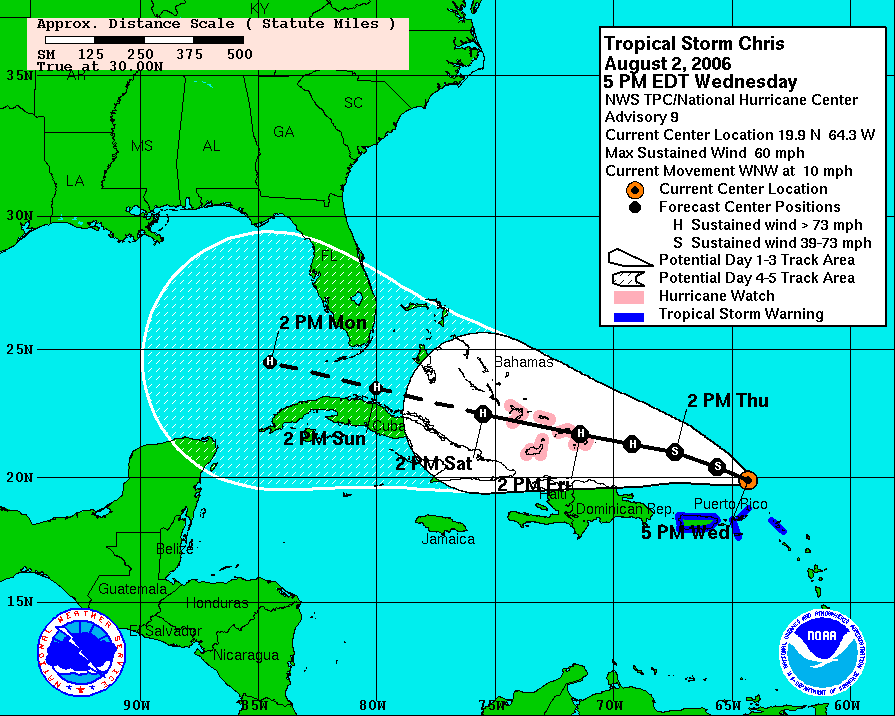 It is important to note that the storm can be anywhere in that shaded area within the next 5 days. The margin of error with tropical storm and hurricane track forecasting increases as the forecast goes out in time. In other words, a lot could change between now and the weekend, but residents of south Florida and the US Gulf Coast should start watching this one.
It is too early to say exactly where Chris may go, but it does have room to intensify over the coming days. We'll keep you posted. Catch our tropical update at :21 after the hour every hour on News 14 Carolina. You can also find the latest online from the National Hurricane Center at http://www.nhc.noaa.gov
No comments:
Post a Comment